- AM1594-: MAP 836
- Item
- 1795 [photocopied between 1973 and 1975]
Part of City of Vancouver Archives technical and cartographic drawing collection
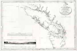
Map shows the discoveries made in 1792 on the north-west coast of North American by examining Juan de Fuca Strait and the corresponding navigable channels, prepared for Dionisio Galiano and Captain Valdes, naval captains of the Royal (Spanish) Fleet in the year 1795.


![New Westminster and Yale [districts]](/uploads/r/null/6/a/f/6af222cb96f4a11f05414783d2a53fe8b7ae9bc99fe2919b35111fb34ec8ef04/8a474785-2c59-42e3-9626-48d0f6f45c3a-MAP82_142.jpg)
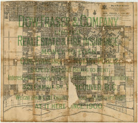

![Map of Vancouver [Districts]](/uploads/r/null/9/6/d/96dab4e0caebc33cf894cb3b406f2b90e6ef7cc76fc6560d5b1f90aa9d7daa81/897a0e6b-e64d-4dba-9551-a094959363c1-MAP808_142.jpg)

![McRoberts Island [Sea Island]](/uploads/r/null/6/9/6981a571c6d3102ee36ac270cce0eca9727531a3a9b4dd09f46f6f61adbbadbe/b8c696f2-5181-4f84-9e76-6420f9b2e916-Map800_142.jpg)


![Plan shewing [showing] division of property belonging to Major C.W. Hill](/uploads/r/null/0/f/0f72067c788c91a520f5055e8b1241e0ee99f2c20c434b03eca0174baea425dc/d22e8a25-814f-4266-99a4-24c639764600-MAP787_142.jpg)


![[Map of Pioneer Place showing the area deeded to the City of Vancouver by the C.P.R.]](/uploads/r/null/4/1/41ba387b96586eb8554abcbf013c0e5cfbb116a42c8d1d1d2311fb1856694b2a/e3bd79d3-cd72-42e4-aa51-bc080514c205-MAP780_142.jpg)


