
- AM1594-MAP 352-: 1972-496.01
- Item
- [1946?]
Part of City of Vancouver Archives technical and cartographic drawing collection
Item is the cover for the brochure of maps of the British Properties development.
1440 results with digital objects Show results with digital objects
Part of City of Vancouver Archives technical and cartographic drawing collection
Item is the cover for the brochure of maps of the British Properties development.

Part of City of Vancouver Archives technical and cartographic drawing collection
Item is an index map for the other maps in the file, showing the British Properties development.

Part of City of Vancouver Archives technical and cartographic drawing collection
Item is a map depicting the area of the British Properties development bordered by Stevens Drive and Rabbit Lane.

Part of City of Vancouver Archives technical and cartographic drawing collection
Item is a map depicting the area of the British Properties development bordered by Stevens Drive and the golf course.
Part of City of Vancouver Archives technical and cartographic drawing collection
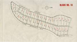
Item is a map depicting the area of the British Properties development bordered by Eyremount Drive, King George's Way and Robin Hood Road.

Part of City of Vancouver Archives technical and cartographic drawing collection
Item is a map depicting the area of the British Properties development bordered by King George's Way and Southborough Drive.

Part of City of Vancouver Archives technical and cartographic drawing collection
Item is a map depicting the area of the British Properties development bordered by Eyremount Drive, King George's Way and Fairmile Road.

Part of City of Vancouver Archives technical and cartographic drawing collection
Item is a map depicting the area of the British Properties development bordered by Fairmile Road, Eyremount Drive and Southborough Drive.

Part of City of Vancouver Archives technical and cartographic drawing collection
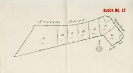
Item is a map depicting the area of the British Properties development bordered by Stevens Drive and Hadden Drive.
Part of City of Vancouver Archives technical and cartographic drawing collection
Item is a map depicting the area of the British Properties development bordered by Stevens Drive and Hadden Drive near Eastcot Road.

Part of City of Vancouver Archives technical and cartographic drawing collection
Part is the front sheet of the unfolded pamphlet includes text on attractions, as well as photographs of the park, petting zoo, monuments, trails and gardens, and Malkin Bowl.

Part of City of Vancouver Archives technical and cartographic drawing collection
Part is the back sheet of the unfolded pamphlet, which is a map showing roads, trails, geographical features and attractions.

Vancouver, B.C., Pacific terminus of the C.P.R.
Part of City of Vancouver Archives technical and cartographic drawing collection
Part is the front page of an unfoldedd brochure. The text describes Vancouver's growth and prospects for the future. Illustrations of different buildings in Vancouver and some parks are also shown.
Ross and Ceperley (Vancouver, B.C.)
City of Vancouver. Canadian Pacific town site
Part of City of Vancouver Archives technical and cartographic drawing collection
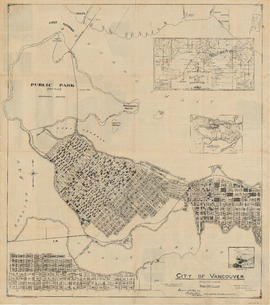
Part is a map sheet with one principal map, three inset maps and one illustration. The main map is a copy of a L.A. Hamilton map of downtown Vancouver and the land surrounding False Creek. Textual information is provided about the history and layout of Stanley Park. Inset maps show the Canadian Pacific mail steamships lines around the world and an index plan of Vancouver, B.C.

Bird's eye view of Vancouver, B.C.
Part of City of Vancouver Archives technical and cartographic drawing collection
Part is an aerial rendering of Vancouver looking westward from a viewpoint east of Hastings Township. The Broadview area is highlighted.
Part of City of Vancouver Archives technical and cartographic drawing collection
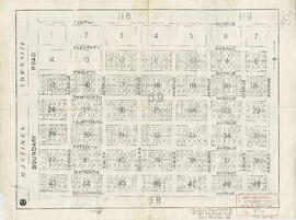
Part is a map of District Lot 69, showing blocks and lots in blocks 12 to 49.

Vancouver airport. Design for Spanish Banks
Part of City of Vancouver Archives technical and cartographic drawing collection
Part is the front page of a brochure, showing cost estimates for various elements of the development.
Part of City of Vancouver Archives technical and cartographic drawing collection
Part is a map shows a proposed plan for the design of Vancouver Airport at Spanish Banks, along with surrounding gardens, a stadium, parks and beaches.

Part of City of Vancouver Archives technical and cartographic drawing collection
![Section 1 [Coal Harbour to Jervis Street]](/uploads/r/null/9/e/9/9e9001a91f4548dd7acb5cf68e9748a8fa0f3d8a10ad9a1235983466dfcc5e1f/d062ae77-a147-4ff8-8a2f-805b659ba7b3-1972-581_142.jpg)
Section 1 [Coal Harbour to Jervis Street]
Part of City of Vancouver Archives technical and cartographic drawing collection
![Section 2 [Jervis Street to Granville Street]](/uploads/r/null/c/f/5/cf5684518fb1cdac0f2d643c89acc078a47fe51a6a1896caf8fcfaf23999a562/c5097ebd-7d02-4ddb-be5e-d0f2658f2849-1972-581_142.jpg)
Section 2 [Jervis Street to Granville Street]
Part of City of Vancouver Archives technical and cartographic drawing collection
![Section 3 [Granville Street to Abbott Street]](/uploads/r/null/f/7/c/f7c18e536d617ec84d3c777f7d3bc02b98868d606842132c28166caaaa2dac3d/7e715850-e92f-48ba-bbc7-3678c5a832df-1972-581_142.jpg)
Section 3 [Granville Street to Abbott Street]
Part of City of Vancouver Archives technical and cartographic drawing collection
![Section 4 [Abbott Street to Gore Avenue]](/uploads/r/null/d/0/b/d0bdb5bfbb8ea9ebfe40ab12d3166035d9041c0874b44ccbcf0feaf7d343e90d/3d33023b-e416-4a39-b51c-f201b58c1e2c-1972-581_142.jpg)
Section 4 [Abbott Street to Gore Avenue]
Part of City of Vancouver Archives technical and cartographic drawing collection
![Section 5 [Gore Avenue to Heatley Avenue]](/uploads/r/null/c/a/9/ca9447df558507296e13d910ed22dcef00b730757d8104a6fdbd5d4e2955a8e1/f669a13d-c71c-4b3a-904d-555f84e054a3-1972-581_142.jpg)
Section 5 [Gore Avenue to Heatley Avenue]
Part of City of Vancouver Archives technical and cartographic drawing collection
![Section 6 [Heatley Avenue to Raymur Avenue]](/uploads/r/null/3/a/0/3a00a7d7ff2433b00b59b0d575006a89ff1e36eea4ecb961d585d3702308874e/61c58478-fbdc-4b03-b27d-4c69089913cd-1972-581_142.jpg)
Section 6 [Heatley Avenue to Raymur Avenue]
Part of City of Vancouver Archives technical and cartographic drawing collection
Item is a sheet of a fire insurance plan. The sheet includes undated revisions to include designs for a new pier west of the Great Northern Railway warehouse and pier.
![Section 7 [Raymur Avenue to McLean Drive]](/uploads/r/null/6/6/9/669640404bae29e74b38e879b94454a054f0417ed40580a028e0db5b976a2e80/614de88a-1a33-4127-8bdf-f328f3cd4e22-1972-581_142.jpg)
Section 7 [Raymur Avenue to McLean Drive]
Part of City of Vancouver Archives technical and cartographic drawing collection
![Section 8 [McLean Drive to Salisbury Drive]](/uploads/r/null/9/1/c/91cb699e74dcee955f380f79208650cd638e651fcce20dbaf91e0f6fd7309854/2dcab9c8-db56-41e3-934c-91dbdfccf6f8-1972-581_142.jpg)
Section 8 [McLean Drive to Salisbury Drive]
Part of City of Vancouver Archives technical and cartographic drawing collection
![Section 9 [Salisbury Drive to McGill and Wall Streets]](/uploads/r/null/2/c/a/2ca00124652bd05f6e2ba7a38be0913c343f9df3ba7b70bb934ceb836de2fa89/dd14b8fd-0710-4ff6-9a02-2a79e289941f-1972-581_142.jpg)
Section 9 [Salisbury Drive to McGill and Wall Streets]
Part of City of Vancouver Archives technical and cartographic drawing collection
![Plate 2 [Hornby Street to Burrard Inlet to Thurlow Street to Pender Street]](/uploads/r/null/8/6/e/86edaec51670e0342c610b1530e723e6bb9890d9ef2f3b0db31ad30f0b559c61/adee6b6a-0b86-4884-b86a-cbcb2773c325-1972-582_142.jpg)
Plate 2 [Hornby Street to Burrard Inlet to Thurlow Street to Pender Street]
Part of City of Vancouver Archives technical and cartographic drawing collection
![Plate 3 [Seymour Street to Burrard Inlet to Hornby Street to Pender Street]](/uploads/r/null/b/6/e/b6e52f14a0b98be97e608633aaf0e2cdd8d5a51d8772a2b1ef80d1b748c7ebdc/eecaa1fa-a58b-4079-bf99-7f62b81de43f-1972-582_142.jpg)
Plate 3 [Seymour Street to Burrard Inlet to Hornby Street to Pender Street]
Part of City of Vancouver Archives technical and cartographic drawing collection
![Plate 4 [Hamilton & Cambie Streets to CP Railway yards to Seymour Street to Pender Street]](/uploads/r/null/7/e/9/7e931c45a666b558ca27b156ef8b243f5244a2820199fe50e04a7aaed21eeb20/06bd9672-ba7d-4013-aaac-2d7c9d8c5188-1972-582_142.jpg)
Plate 4 [Hamilton & Cambie Streets to CP Railway yards to Seymour Street to Pender Street]
Part of City of Vancouver Archives technical and cartographic drawing collection
![Plate 5 [Abbott Street to CP Rail right-of-way to Cambie Street to Pender Street]](/uploads/r/null/6/b/0/6b0b7025ad796cf3c24bd82d3128128aeb9437211623e8b002f3aa257584f3d8/b2e8d0db-d7d6-463d-9eed-a04b68cd2033-1972-582_142.jpg)
Plate 5 [Abbott Street to CP Rail right-of-way to Cambie Street to Pender Street]
Part of City of Vancouver Archives technical and cartographic drawing collection
![Plate 6 [Carrall Street to Water Street to Abbott Street to Pender Street]](/uploads/r/null/2/9/d/29d9b87c8a0b2ec0ebe43b7a1b209cf540943a17fcdf02f7fbf229b97c9beb06/65cae868-4124-4b7f-bb47-c6364f18c039-1972-582_142.jpg)
Plate 6 [Carrall Street to Water Street to Abbott Street to Pender Street]
Part of City of Vancouver Archives technical and cartographic drawing collection
![Plate 7 [Main Street to Powell Street to Columbia Street to Pender Street]](/uploads/r/null/d/f/b/dfb6afa705be957fb1edcc4db4eebed9e70de2f7da4428a558a100303c04c15c/49c15b71-8829-4feb-b5c6-1643c02b3907-1972-582_142.jpg)
Plate 7 [Main Street to Powell Street to Columbia Street to Pender Street]
Part of City of Vancouver Archives technical and cartographic drawing collection
![Plate 10 [CPR yards between Pender Street and Georgia viaduct]](/uploads/r/null/4/d/f/4df4324d57fa032950845b1be5ae2e04c2707c20e598bf307101a36ba7929130/176fae2d-a49c-4f75-99db-5ec876a739ce-1972-582_142.jpg)
Plate 10 [CPR yards between Pender Street and Georgia viaduct]
Part of City of Vancouver Archives technical and cartographic drawing collection
![Plate 11 [Great Northern, Canadian Pacific and BC Electric rail wards south of Pender Street]](/uploads/r/null/e/3/8/e3845e99a86b7c63562774d7ac49596466047a1ef5d4daf1ede5be765cc5f434/7338b83f-7dd7-4768-832b-57a4c33a7cc2-1972-582_142.jpg)
Plate 11 [Great Northern, Canadian Pacific and BC Electric rail wards south of Pender Street]
Part of City of Vancouver Archives technical and cartographic drawing collection
![Plate 16 [Seymour Street to Pender Street to Hornby Street to Georgia Street]](/uploads/r/null/5/b/3/5b3e6b9c6b363ebf8647de3c6cbd08be134849a51c2afb6ae2d8270992423224/1bbec413-4808-4972-ba42-96d87508f044-1972-582_142.jpg)
Plate 16 [Seymour Street to Pender Street to Hornby Street to Georgia Street]
Part of City of Vancouver Archives technical and cartographic drawing collection
![Plate 17 [Hamilton Street to Pender Street to Seymour Street to Georgia Street]](/uploads/r/null/d/b/0/db02a6582e4c80b48f4280307b3a1bf96e118648e3076fd16fe61c9a33d078a4/9e87cf0f-995c-4324-92af-170d1a2248d5-1972-582_142.jpg)
Plate 17 [Hamilton Street to Pender Street to Seymour Street to Georgia Street]
Part of City of Vancouver Archives technical and cartographic drawing collection
![Plate 18 [Seymour Street to Georgia Street to Hornby Street to Smithe Street]](/uploads/r/null/1/a/4/1a4187cb3019a9f0a84f3d7a4ffed7e4cb88181cbd49481d7904d57b9dfd1cc6/bd298293-e0af-4e5a-b89c-faab9207fc67-1972-582_142.jpg)
Plate 18 [Seymour Street to Georgia Street to Hornby Street to Smithe Street]
Part of City of Vancouver Archives technical and cartographic drawing collection
![Plate 19 [Hamilton Street to Georgia Stret to Seymour Street to Smithe Street]](/uploads/r/null/0/e/c/0ecea3ead6474f95320d3370c410bde1bef129fc8bcb8e54709f6f4aae7e3461/561bca07-f000-4835-ad8e-9e2bda093863-1972-582_142.jpg)
Plate 19 [Hamilton Street to Georgia Stret to Seymour Street to Smithe Street]
Part of City of Vancouver Archives technical and cartographic drawing collection
![Plate 20 [Canadian Pacific yards from Carrall to Cambie Streets]](/uploads/r/null/f/3/b/f3b975362fee829daa72ab5af0d232c1f708ace37eb7810d8d2b208654cc09de/6a8c2b21-697c-42dd-9a82-583843792237-1972-582_142.jpg)
Plate 20 [Canadian Pacific yards from Carrall to Cambie Streets]
Part of City of Vancouver Archives technical and cartographic drawing collection
![Plate 21 [Main Street to Burrard Inlet to Carrall Street to Powell Street]](/uploads/r/null/3/3/9/33932f79e18327df8668330a3339de71cd31ff138df12adfc181b243ef196a83/e82c7b04-8b9c-481e-b633-e2125e5cdcda-1972-582_142.jpg)
Plate 21 [Main Street to Burrard Inlet to Carrall Street to Powell Street]
Part of City of Vancouver Archives technical and cartographic drawing collection
![Plate 28 [Rogers Street to Burrard Inlet to Raymur Avenue to Powell Street]](/uploads/r/null/a/d/4/ad448e6434aca51e0c80d95d998867b723fddcca85b2c25a6ac6630b3eceff50/5bfa1e47-4599-430a-9aba-d4d40a02d674-1972-582_142.jpg)
Plate 28 [Rogers Street to Burrard Inlet to Raymur Avenue to Powell Street]
Part of City of Vancouver Archives technical and cartographic drawing collection
![Plate 29 [Hastings Shingle site south to Canadian Pacific right-of-way]](/uploads/r/null/f/e/9/fe9794e3d85879cdcfd458dbc35d2a43d9909ddf1d80b18977f257753e20caa4/83063196-bd17-4e9f-b4a0-77d37d226d87-1972-582_142.jpg)
Plate 29 [Hastings Shingle site south to Canadian Pacific right-of-way]
Part of City of Vancouver Archives technical and cartographic drawing collection
![Plate 42 [Denman Street to Burrard Inlet to Chilco Street to Georgia Street]](/uploads/r/null/2/b/0/2b0746ea5672c134a873ff4b093d2b9354e08e820114151c3174f746ae4765da/75916d07-7c70-452c-8df0-fef3c04b128e-1972-582_142.jpg)
Plate 42 [Denman Street to Burrard Inlet to Chilco Street to Georgia Street]
Part of City of Vancouver Archives technical and cartographic drawing collection
![Plate 43 Cardero Street to Burrard Inlet to Denman Street to Georgia Street]](/uploads/r/null/2/3/a/23abbc83a718d4fe100dd94c7dd0ba4eb96bbf4e316288ebe90a5dc49bbb699b/0b843b5a-9b76-4d60-88dd-3031b79cfa17-1972-582_142.jpg)
Plate 43 Cardero Street to Burrard Inlet to Denman Street to Georgia Street]
Part of City of Vancouver Archives technical and cartographic drawing collection
![Plate 44 [Broughton Street to Burrard Inlet to Cardero Street to Georgia Street]](/uploads/r/null/9/7/f/97fe393ffef9573e51010bcf888bf28e80a2af453e3bc4eea7e18d5da8cbf5ba/e7313e27-ba16-47e7-8484-f929feac471e-1972-582_142.jpg)
Plate 44 [Broughton Street to Burrard Inlet to Cardero Street to Georgia Street]
Part of City of Vancouver Archives technical and cartographic drawing collection
![Plate 45 [Bute Street to Burrard Inlet to Broughton Street to Georgia Street]](/uploads/r/null/6/b/2/6b2bd68ef43ef508e6b5e73ccc11be2e4c6eba69186ef83b384696ef0cf030ed/1debecf1-3785-4682-8575-a9474149bc36-1972-582_142.jpg)
Plate 45 [Bute Street to Burrard Inlet to Broughton Street to Georgia Street]
Part of City of Vancouver Archives technical and cartographic drawing collection
![Plate 46 [Thurlow Street to Canadian Pacific right-of-way to Bute Street to Georgia Street]](/uploads/r/null/5/9/f/59fddbd648aac61a1c6c56b0121fac2a9f07bd91756ebdf08cd47779553b2c7d/c80bf37d-14f8-4766-8e8c-2542a5ce2b71-1972-582_142.jpg)
Plate 46 [Thurlow Street to Canadian Pacific right-of-way to Bute Street to Georgia Street]
Part of City of Vancouver Archives technical and cartographic drawing collection
![Plate 47 [Hornby Street to Pender Street to Thurlow Street to Georgia Street]](/uploads/r/null/0/6/8/0682899a1add7d3f6ef14e4aa250437377cc525aeea8cd8d3a1d64f81636b222/413a1cd4-4fee-46b5-b49c-96b3cd30f8ce-1972-582_142.jpg)
Plate 47 [Hornby Street to Pender Street to Thurlow Street to Georgia Street]
Part of City of Vancouver Archives technical and cartographic drawing collection