
- AM54-S4-: St Pk N150.01
- Item
- 9 Apr 1956
Part of Major Matthews collection
144 results with digital objects Show results with digital objects
Part of Major Matthews collection
![[View of Chaythoos, the site where Lord Stanley dedicated Stanley Park]](/uploads/r/null/0/5/055a931f850a66bbc18985aff5e519ff7a5296c6f7517e31cd933fdb48f667e4/31496bb5-7ba9-4767-9c4f-3681f4b8a1d0-A10266_142.jpg)
[View of Chaythoos, the site where Lord Stanley dedicated Stanley Park]
Part of Major Matthews collection
![[People at Chaythoos, the site where Lord Stanley dedicated Stanley Park]](/uploads/r/null/2/f/2f75190184dba224d2afaa121e3f70a2d7300cbb712816d0caea730dd3bf31a1/b34cfa0b-5b7a-4ab3-bd1a-48bdf2b35f3e-A10267_142.jpg)
[People at Chaythoos, the site where Lord Stanley dedicated Stanley Park]
Part of Major Matthews collection
![[View of Stanley Park causeway]](/uploads/r/null/1/4/1400cb0870559e653058060d461a4c40f2d71d31f5a272b7b5cc27f422df06ba/1012a3da-487c-41b2-97a3-2acab239d2bb-A71130_142.jpg)
[View of Stanley Park causeway]
Part of Major Matthews collection
Photograph shows street level view of Stanley Park causeway. Major Matthews used this photograph in deciding the location of the Lord Stanley statue.
![[View of Chaythoos, the site where Lord Stanley dedicated Stanley Park]](/uploads/r/null/5/3/5393c8c83d02446914542c1c7bb3f3fcd6462fe1187f255161491c213bc343f1/116c398d-2a4a-46ea-b00a-b528cc7e6ae1-A10265_142.jpg)
[View of Chaythoos, the site where Lord Stanley dedicated Stanley Park]
Part of Major Matthews collection
Part of City of Vancouver Archives technical and cartographic drawing collection
Item is a brochure for tourists on Stanley park. The front sheet of the unfolded pamphlet includes text on attractions, as well as photographs of the park, petting zoo, monuments, trails and gardens, and Malkin Bowl. The reverse of the sheet contains a map of the park, showing roads, trails, geographical features and attractions.

Stanley Park, four totem poles
Item is a photograph of four totem poles near Lumberman's Arch in Stanley park. The poles are (L-R): the Sisa-Kaulas Pole, the two Thunderbird House Posts pole and the Chief Wakas Pole (second from the right).

Stanley Park, entrance and roadway

Stanley Park, visitors and rows of flowers in garden

Stanley Park, painter on bench
Item is a photograph of a man with a pochade box sitting on a bench in Stanley Park, with paint brushes in his hands. Other park visitors and park scenery may be seen in the background.

Item is a photograph of park visitors boating in Lost Lagoon, Stanley Park.

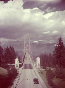
Stanley Park, Lions Gate Bridge southern approach
Item is a photograph of the southern approach to the Lion's Gate Bridge from Stanley Park. Looking north across the bridge, the road, decorative lions and pylons, and cables and piers are visible.

Item is a photograph of a rough carved wooden sign saying "Stanley Park" resting on two logs.
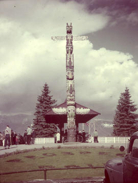
Item is a photograph of the totem pole, buildings, landscaping, and visitors at Prospect Point in Stanley Park.

Stanley Park, Shakespeare Memorial
![Wilson [Harding] memorial, Stanley Park](/uploads/r/null/6/8/e/68e3a71452408ba9791fc140e1befcb53d79722b0251cbd86632949a37835c0c/77c422b7-125a-44e2-8a8b-9850a21f7699-CVA72-53_142.jpg)
Wilson [Harding] memorial, Stanley Park
Item is a photograph of the Warren G. Harding Memorial in Stanley Park.

Item is a photograph of the Chief Skedans Mortuary Pole (replaced with a replica in 1965) near Lumberman's Arch in Stanley Park.


Stanley Park, fountain in duck pond
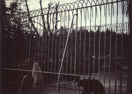
Stanley Park, bear cage with two polar bears and two grizzly bears
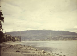
Stanley Park, Lions Gate Bridge from seawall beach

Item is a photograph of five totem poles near Lumberman's Arch in Stanley park. Two identified poles are the Thunderbird House Post pole at the far left, and the Chief Wakas totem pole second from the left.

Item is a photograph of a view of a rock garden in Stanley Park.

Japanese cherry trees, Stanley Park; 1950
Item is a photograph of Japanese cherry trees in bloom around the Japanese Memorial in Stanley Park.

Part of City of Vancouver Archives technical and cartographic drawing collection
Map shows trails, bridle trails, and main driveways in Stanley Park.
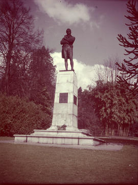
Robbie Burns statue, Stanley Park; Vancouver, Mar 18/50
Item is a photograph of the Robert Burns Memorial in Stanley Park.

Swans and ducks on Stanley Park duck pond
Part of City of Vancouver fonds

Marine Drive, Stanley Park, Totem pole : Scenics Vancouver

Brockton Point - Stanley Park - Vancouver, B.C.
Part of George Thompson fonds

Stanley Park - Vancouver - B.C.
Part of George Thompson fonds

Entrance to Stanley Park - Vancouver, B.C.
Part of George Thompson fonds
Rededication, Stanley Park, 1943
Part of Major Matthews collection
Album contains photographs of the rededication ceremony in 1943, copy photographs of the original dedication of the park in 1889 and early scenes of Stanley Park. Album was dedicated to Lord Derby, son of Lord Stanley, and includes Lord Derby's invitation to the ceremony as well as Major Matthews' notes with the photographs.

![Stanley Park [Golden Jubilee]](/uploads/r/null/2/4/24135e2d726e60ffbc74f0d81c3a53d51a38fe9ea1e86ecda92708249adac23b/1b46df5d-6871-41b2-b1dd-91a0c1d5ad02-MAP624_142.jpg)
Part of City of Vancouver Archives technical and cartographic drawing collection
Item is a copy of a map of Stanley Park which has been extensively annotated to depict plans for addressing traffic, parking and pedestrian regulations for events held in the park during the City's Golden Jubilee celebrations July-Sept. 1936.
Vancouver (B.C.). Board of Park Commissioners

Part of City of Vancouver Archives technical and cartographic drawing collection
Map shows main roads, trails, bridle trails and landmarks in Stanley Park.
![The main driveway [in Stanley Park]](/uploads/r/null/a/e/7/ae7d26040eb047445ac6e3f86f099f48e40cd4dc631b1ad6c5e0706b324b67c6/a2d2a295-e2ea-4172-a86d-60b5592a2057-CVA294-097_142.jpg)
The main driveway [in Stanley Park]
Part of Bertram Emery fonds
![The Harding Memorial [in Stanley Park]](/uploads/r/null/2/1/b/21b3b4ca1fe0fc0ab88242480cd4693328a9d15b3888cf647323f49605262bca/9b3f676a-4728-4025-8594-6d8d32a9599e-CVA294-102_142.jpg)
The Harding Memorial [in Stanley Park]
Part of Bertram Emery fonds
![The big hollow tree [in Stanley Park]](/uploads/r/null/7/1/d/71dd471bb3e489e87440f39fce86dc0cbee97d7491e4a96fc75dc541671cb1e8/755a7513-4fbc-4472-b196-1378e65ee367-CVA294-104_142.jpg)
The big hollow tree [in Stanley Park]
Part of Bertram Emery fonds
![The Causeway, Main Entrance to [Stanley] Park](/uploads/r/null/6/2/1/62107c1dcecc90f3fac8d2465a6501bdcbb40108a405245178bf05af632be2cb/e7086039-3a16-4026-8500-baff2ce19f14-CVA294-105_142.jpg)
The Causeway, Main Entrance to [Stanley] Park
Part of Bertram Emery fonds
![Entrance to Stanley Park [from above]](/uploads/r/null/f/4/e/f4e909af0fe287a6195b2388036e4f016ab747391c3ae98e26642465908f5975/66ed01b0-0e9f-4951-a59e-eea2b423033c-CVA294-087_142.jpg)
Entrance to Stanley Park [from above]
Part of Bertram Emery fonds
![Prospect Point [Stanley Park]](/uploads/r/null/4/6/0/460d311a6eaa7786807e839976da63f9a70af27a5a8a2ef1131359bc93f52f64/bd734f26-7476-46e1-97d1-20e2e2cb4944-CVA294-101_142.jpg)
Part of Bertram Emery fonds
![[The] Grave of Pauline Johnson](/uploads/r/null/e/7/e/e7e1d1ecc114a542834a819c67f9c7f8ce369dc05a3e294ee38854ed4eda8202/3e203a8c-1755-4b43-9a7e-af6391d17255-CVA294-103_142.jpg)
[The] Grave of Pauline Johnson
Part of Bertram Emery fonds
Part of L.D. Taylor family fonds
File consists of images of early Vancouver, including Gastown, Hastings Mill, Granville Street, Burrard Inlet, Prospect Point, the first City Council, arrival of the first C.P.R. train, Cordova Street, and Mount Pleasant.
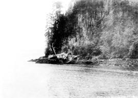
Wreck of the Beaver, Prospect Point
Part of L.D. Taylor family fonds

Part of William Orson Banfield fonds

Some of the birds in Stanley Park
Part of William Orson Banfield fonds

Standard tourists' guide to Stanley Park, Vancouver, B.C.
Part of City of Vancouver Archives technical and cartographic drawing collection
Item is a tourist guidebook to Stanley Park, including a brief history, instructions for vehicle access, and a map with associated index to points of interest. The back of the cover lists "A Few Facts About Vancouver. The map notes driving routes in the park, trails and walking routes.

Plan showing lands occupied in Stanley Park near Brockton Point, City of Vancouver, B.C.
Part of City of Vancouver Archives technical and cartographic drawing collection
Map shows parcels of land (1-8) in Stanley Park and indicates what kind of structures are located on the land. The area for each parcel of land is given in acres.
Part of City of Vancouver Archives technical and cartographic drawing collection
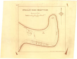
Item is a copy of a map showing a portion of Stanley Park and parcels of land labelled with surnames of identified squatters.