Add to clipboard
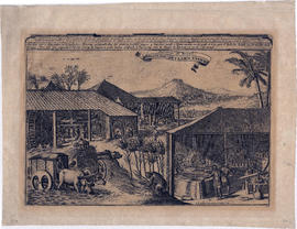
Sucreries du Bresil. Brasilise suyker werken
Add to clipboard
Water powered cane mill, West Indies
Map of the world, western continent undiscovered
Add to clipboard
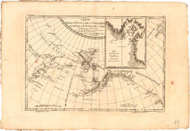
Map of the world, western continent undiscovered
Map of the world, west coast of Canada still unknown
Add to clipboard
Map of the world, west coast of Canada still unknown
Add to clipboard
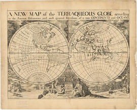
A new map of the terraqueous globe
Add to clipboard
A new map of the terraqueous globe
Add to clipboard
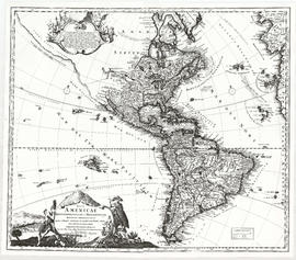
Totius Americae
Add to clipboard
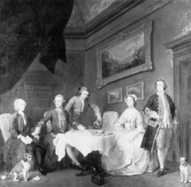
The Strode Family
New England Colonies, 1754, from Gentleman's Magazine
Add to clipboard
New England Colonies, 1754, from Gentleman's Magazine
North West Passage, 1592, 1603 Strait of Juan De Fuca
Add to clipboard
North West Passage, 1592, 1603 Strait of Juan De Fuca
Add to clipboard
Carte reduite des parties septentrionales du globe, situees, entre l'Ansie et l' Amerique, pour fervir a l'histoire generale des voyages
Wolfe, James, photostat of letter written in 1758, Carleton & Vancouver specimens
Add to clipboard
Wolfe, James, photostat of letter written in 1758, Carleton & Vancouver specimens
Add to clipboard
Engraving of cane mill
Photostat letters Gen[eral] James Wolfe & Sir Guy Carleton Jan. 1858 and July 1759 in 1 glassine envelope
Add to clipboard
Photostat letters Gen[eral] James Wolfe & Sir Guy Carleton Jan. 1858 and July 1759 in 1 glassine envelope
North West Passage, early map of, 1760, route to Europe
Add to clipboard
North West Passage, early map of, 1760, route to Europe
Endeavour - bark
Add to clipboard
Endeavour - bark
Endeavour - bark
Add to clipboard
Endeavour - bark
Death of General Wolfe (copy)
Add to clipboard
Death of General Wolfe (copy)
Raleigh - sloop
Add to clipboard
Raleigh - sloop
Marquis of Granby (Endeavour) - bark
Add to clipboard
Marquis of Granby (Endeavour) - bark
Add to clipboard
The asiatic part of the Russian empire
Add to clipboard
A map of the whole continent of America divided into North and South and West Indies
Add to clipboard
Sugar refining engravings from Diderot. Pl. II, [plate 2] OEconomie Rustique, Sucrerie
Add to clipboard
Sugar refining engravings from Diderot. Pl. I, [plate 1] OEconomie Rustique, Sucrerie
Add to clipboard
Sugar refining engravings from Diderot. Pl. IV, [plate 4] OEconomie Rustique, Sucrerie
Add to clipboard
Sugar refining engravings from Diderot. Pl. VI, [plate 6] OEconomie Rustique, Affinerie des Sucres
Adventure - sloop
Add to clipboard
Adventure - sloop
Add to clipboard
The Russian discoveries from the map published by the Imperial Academy of St. Petersburg
Adventure - sloop
Add to clipboard
Adventure - sloop
Indenture of Apprenticeship of David Beach, Morris County, Province of New Jersey, son of Abner Beach, to Benjamin Beach to learn the trade of Bloomer.
Add to clipboard
Indenture of Apprenticeship of David Beach, Morris County, Province of New Jersey, son of Abner Beach, to Benjamin Beach to learn the trade of Bloomer.
Add to clipboard
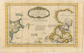
Carte de la cote N.O. de l' Amerique et de la cote N.E. de l'Asie
Scientia terrarum et coelorum
Add to clipboard
Scientia terrarum et coelorum
George Vancouver, 1757-1798, collection
Add to clipboard
George Vancouver, 1757-1798, collection
Add to clipboard
Chart of the n.w. coast of America and n.e. coast of Asia explored in the years 1778 and1779
North America
Add to clipboard
North America
Add to clipboard
A general chart: exhibiting the discoveries made by Capt. James Cook
Add to clipboard
North America
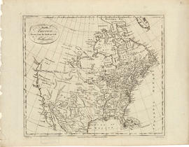
Map of North America, 1787
Add to clipboard
Map of North America, 1787
Indenture of sale, Benjamin Beach to David Beach, of certain lands in Township of Pequanack, Morris County, New-Jersey.
Add to clipboard
Indenture of sale, Benjamin Beach to David Beach, of certain lands in Township of Pequanack, Morris County, New-Jersey.
Add to clipboard
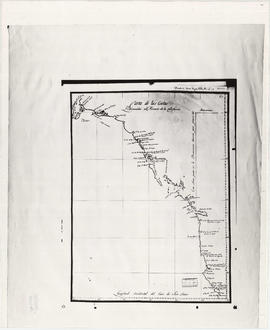
Carte de la riviere de Cook dans la partie N.O. de l'Amerique
Add to clipboard
Carta de las costas reconocidas al Norueste de la California
Add to clipboard
Kaart van de noord-west kust van Amerika en de noord-oost kust van Asia
Add to clipboard
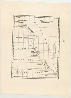
North part of the great sea, Pacific Ocean
Add to clipboard
Algemeene kaart : van de ontdekkingen van Kapit. J. Cook
Discovery - sloop
Add to clipboard
Discovery - sloop
British Columbia, 1790, unknown coast of North America, Gentleman's Magazine, 1790
Add to clipboard
British Columbia, 1790, unknown coast of North America, Gentleman's Magazine, 1790
Jose Maria Narvaez, 1791, map Burrard Inlet, Strait of Georgia, Spanish names
Add to clipboard
Jose Maria Narvaez, 1791, map Burrard Inlet, Strait of Georgia, Spanish names
Portion of a map of the Straits of Juan de Fuca
Add to clipboard
Portion of a map of the Straits of Juan de Fuca
Mackenzie, Alexander, 1793, a map of Mackenzie's track from Fort Chipewyan to the Pacific Ocean
Add to clipboard
Mackenzie, Alexander, 1793, a map of Mackenzie's track from Fort Chipewyan to the Pacific Ocean
Add to clipboard
Chart of the N.W. coast of America and the N.E. coast of Asia


![Sugar refining engravings from Diderot. Pl. II, [plate 2] OEconomie Rustique, Sucrerie](/uploads/r/null/8/5/f/85fc735737a5be5447e16d7f61a2fe47745d184eba53b20ddc3bbb391fe2507c/099f1aaf-049e-49bc-880c-c90888f465e3-2011-092_142.jpg)
![Sugar refining engravings from Diderot. Pl. I, [plate 1] OEconomie Rustique, Sucrerie](/uploads/r/null/1/7/1/1719fc7dc9ea204d8831ec96bec12051803be7f92ef672eec2d3e26e3c85a5c7/f8b9c246-ea0d-4c9b-b020-11bc479dcb6b-2011-092_142.jpg)
![Sugar refining engravings from Diderot. Pl. IV, [plate 4] OEconomie Rustique, Sucrerie](/uploads/r/null/6/e/5/6e5e78cf81f72a0bd1aa2b38415f43019455b1bb8d50dec329c562121905db12/ed9193e4-7ef4-4394-b8f8-a97f9bf684cc-2011-092_142.jpg)
![Sugar refining engravings from Diderot. Pl. VI, [plate 6] OEconomie Rustique, Affinerie des Sucres](/uploads/r/null/6/d/d/6ddfbb426ea603f8333a8f65bed9422d353c1920a2bdadc48b05996b161ad9b4/b358e166-ced5-4060-967f-728c70a6eda0-2011-092_142.jpg)