[View of rock formation in Avalon Harbor at Santa Catalina Island]
[View of Pender Street between Burrard and Thurlow Streets, showing ships in harbour]
[View of Pender Street between Burrard and Thurlow Streets, showing houses and ships in harbour]
[View of] Parliament Building , illuminated [at night, Victoria, B.C.]
[View of] Ocean Falls [harbour and buildings]
[View of] Ocean Falls [from harbour]
View of Fisherman's Cove taken from highway to Horseshoe Bay
[View of Empress Hotel taken from inner harbour]
[View of] Deep Cove
[View of Deadman's Island and Coal Harbour]
[View of Coal Harbour, Deadman's Island, part of Stanley Park, and the North Shore mountains, from John Morton's clearing at the foot of Thurlow Street]
[View of Coal Harbour, Deadman's Island, part of Stanley Park, and the North Shore mountains from the foot of Bute Street]
[View of Coal Harbour, Deadmans Island, and North Shore mountains from foot of Thurlow Street]
[View of Coal Harbour showing Pier D, dredging, and C.P. railway yard]
[View of Coal Harbour looking west from the foot of Broughton Street]
[View of Coal Harbour from Vancouver]
[View of Coal Harbour from the causeway]
[View of Coal Harbour and the rear of Queen Victoria's Memorial from Stanley Park]
[View of] Coal Harbour and Stanley Park from Georgia [Street]
[View of clearing at foot of Burrard Street, showing ships in harbour]
[View of Burrard Inlet toward Howe Sound from Point Grey]
[View of Burrard Inlet from Point Grey]
[View of Avalon Harbor at Santa Catalina Island]
[View of Avalon Harbor at Santa Catalina Island]
[View of Avalon Harbor at Santa Catalina Island]
[View from seawall in Stanley Park - Canadian "Empress" liner entering harbour]
[View across Coal Harbour towrds Downtown]
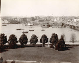
Victoria, B.C. from Government Buildings
Victoria Harbour from C.P.R. Hotel, Victoria, B.C.
![[View of rock formation in Avalon Harbor at Santa Catalina Island]](/uploads/r/null/e/3/e3aaf19c0247951aa4bcd8b9a1f129120747587064bc56811243d6e16aa5088f/d01725e0-69c7-4546-8bd6-dcc25d9d802b-CVA1477-516_142.jpg)
![[View of Pender Street between Burrard and Thurlow Streets, showing ships in harbour]](/uploads/r/null/7/8/78e5ebf660d4be04085232c4df48a55b2f53fc69b8b24917d11a327c279b273e/238ef5af-164f-4608-b421-7f1ea11419d7-A07605_142.jpg)
![[View of Pender Street between Burrard and Thurlow Streets, showing houses and ships in harbour]](/uploads/r/null/f/0/f00ac5f1f323bcee985db1f23354ad1a01e377075c05ff005e8291cfa6ea59bb/257c6f06-9e48-4b7a-8964-00daf6a2493f-A07603_142.jpg)
![[View of] Parliament Building , illuminated [at night, Victoria, B.C.]](/uploads/r/null/d/c/dc81d0d58c91faf1768ff62befeceee86d29ea5df52f6d2f0480ecd47adac3ec/efed1773-3d50-494b-8786-acab1c88657f-A06943_142.jpg)
![[View of] Ocean Falls [harbour and buildings]](/uploads/r/null/3/3/33daeb90796231f592329cba7a2cbd32a2d2e5ec9d397a7151a925a416d514b8/860dc270-0c78-4f59-9c8e-a01712ccce45-A07221_142.jpg)
![[View of] Ocean Falls [from harbour]](/uploads/r/null/a/c/ac01a62213024629cc4ad1b26c89a5bc072b7b6495192754174509e3aa713da0/d414e587-97bb-4d8e-99e2-b8f5ef2471f8-A07225_142.jpg)

![[View of Empress Hotel taken from inner harbour]](/uploads/r/null/8/d/8d8d1dfc7f784994ae144478452634025ae389b410f8c73b66c10e64907f2901/bb1420c3-35d0-474a-8b94-85423c9cf348-A15720_142.jpg)
![[View of] Deep Cove](/uploads/r/null/1/a/1a18c33f69dd89ad4f2e79c0137c837c16e817069547777a7c1f9daf2542a46f/4fe48ffe-0985-498a-acd7-92c6d74245b0-A03406_142.jpg)
![[View of Deadman's Island and Coal Harbour]](/uploads/r/null/8/0/80683adb4e0b7498798804e3d05daf6be844a6f263642f946a52c6c79c258681/c2f926a9-4ca4-48d8-a08d-207d4325c9b1-A08035_142.jpg)


![[View of Coal Harbour, Deadmans Island, and North Shore mountains from foot of Thurlow Street]](/uploads/r/null/4/c/4ce8248f3e2c6a40b98fe6815778e930d730e9bc6fef96c61b3f9f0715075431/ed4d630a-fcce-461f-aaaa-3bab818f9bc6-A07647_142.jpg)
![[View of Coal Harbour showing Pier D, dredging, and C.P. railway yard]](/uploads/r/null/a/f/af0c10ae5aeb61ca4a197b4e372f1862f6fa32fb58347e2b94148897eec5e3c3/a7b91197-362d-42d1-b2a2-df14d10f4656-A63942_142.jpg)
![[View of Coal Harbour looking west from the foot of Broughton Street]](/uploads/r/null/9/3/938ee0983c20bbbe94d9286541d172633e29b57b47a906f60e6e43fc2d15dda0/0fd8b222-d407-4f8f-a363-f7b88343cbe3-A08809_142.jpg)
![[View of Coal Harbour from Vancouver]](/uploads/r/null/a/d/ad3804d91a35387f53f4c5858b7f68b9c622339a85523df7f8917001ab7d3c74/187cecca-d78f-4911-826f-3d952d4df917-A01985_142.jpg)
![[View of Coal Harbour from the causeway]](/uploads/r/null/a/1/a11c5844a676582424273c284cfec188f2dfc6c90cb9dd46a741be593d2a3456/caed5a3c-25db-483c-8ad9-fde5e565c38b-A75614_142.jpg)
![[View of Coal Harbour and the rear of Queen Victoria's Memorial from Stanley Park]](/uploads/r/null/4/3/43de497a997e0f724c44d286a5777cf01177bc80cf064bb190ff8d322f1a3431/ab850521-fb13-4aa6-8b76-7ae76dab47a7-A64524_142.jpg)
![[View of] Coal Harbour and Stanley Park from Georgia [Street]](/uploads/r/null/8/c/8c0a3b0f859c1a378c1463bc15fea75d46976a8289b6c84fcabef3840f06a3b3/490e919d-235c-4eb3-8693-3641e4b6285c-A09696_142.jpg)
![[View of clearing at foot of Burrard Street, showing ships in harbour]](/uploads/r/null/7/8/78b3af6cd868bbad006ed34e13d07aa777902e54bdd3decb808046646b9b01a3/842ea67f-73eb-447a-adf2-428d6245779a-A07604_142.jpg)
![[View of Burrard Inlet toward Howe Sound from Point Grey]](/uploads/r/null/d/7/d70841724af53c279a31c140bbc1fce42a0aa6a1d3a9c40cff087f263ccc345d/7095bde6-1c57-4e91-b87a-60bb6b7cd9f3-A64735_142.jpg)
![[View of Burrard Inlet from Point Grey]](/uploads/r/null/e/3/e320d8072b352225b343a6bf036a24dfbe3d1f2d722001dd0b12d0aa899d36bb/bb12fe87-3475-4839-9e59-891393008d05-A64782_142.jpg)
![[View of Avalon Harbor at Santa Catalina Island]](/uploads/r/null/f/d/fdf3a14b471b917b980dbdcf659078213b34df352708beb19482ea5610608647/a3fc8135-be2c-49fe-878d-0d214a9bc4d0-CVA1477-515_142.jpg)
![[View of Avalon Harbor at Santa Catalina Island]](/uploads/r/null/d/f/df0c029ba2b136ed552f01672979bc7f99aa8f69654812e869a742485f26bd0f/b48b0662-55fd-4b82-804d-e4f46a0f75cb-CVA1477-512_142.jpg)
![[View of Avalon Harbor at Santa Catalina Island]](/uploads/r/null/f/4/f4dd649d269242f020c71cefa964c09dda63a4e1aa7e8c19e7c0fc5486a37c15/c0e2a045-354a-422d-8c61-07d2f6d326fa-CVA1477-513_142.jpg)
![[View from seawall in Stanley Park - Canadian "Empress" liner entering harbour]](/uploads/r/null/2/5/25fd04fc60eae388a1723df89763f698db6b1f82f3a238202dc958a349de9ed0/9745dd51-1597-4be6-b778-a94a7d273499-A00141_142.jpg)
![[View across Coal Harbour towrds Downtown]](/uploads/r/null/d/d/ddf2d63627f742e05eab0ed197b3b40bc910fd24a176af8b9a75db9e2dd8133c/db7f74b3-f519-43e2-af80-62d88342cfea-A74506_142.jpg)


![Vancouver, B.C. [harbour]](/uploads/r/null/e/e/7/ee708b0db0405bf0ce74a6bbfb6a7f3051113fe9b62dc8bbb09a258b397f6462/dffb3ad4-5037-401d-83bd-0864ee9ab76e-AM1052P-2250_142.jpg)


![Vancouver Rowing Club spring training [Coal Harbour]](/uploads/r/null/9/f/9f7a52b4234a10b643833b548607d4a7965eb5ddb0039ac98c5dd1d0578efde9/b767371a-9449-4a59-9a3d-7b382649db2c-A01112_142.jpg)
![Vancouver Rowing Club spring training [Coal Harbour]](/uploads/r/null/f/2/f29c3244621fb7af84bfcc09765f9cfb543600fb05146bbcc27ef047d41250f2/898c386a-e0a7-4f8b-8e8d-166075f5e582-A01113_142.jpg)


![Vancouver Rowing Club regatta [in Coal Harbour]](/uploads/r/null/c/c/cc532fdff705de55bc0b6842e761be540ea0502006d93ba757a04bdcf43c0754/7efba8d0-fa54-4a22-8c96-2f89d7bbe641-A00747_142.jpg)
![Vancouver Rowing Club regatta [in Coal Harbour]](/uploads/r/null/a/e/aea8be199ec45ccdd094f8522d641eeb65f1727a99257a6fd819f5fc1a238747/07b65312-a17f-4a09-a8ad-6f5d06c86828-A00750_142.jpg)
![Vancouver Rowing Club regatta [in Coal Harbour]](/uploads/r/null/0/d/0dacb294e11c83a59dd81a3f85afad90b131541a64d484e91988767486e25957/83fcf926-ff85-4332-abce-dcdf93f7b676-A00749_142.jpg)
![Vancouver Rowing Club Regatta [Coal Harbour - view toward downtown]](/uploads/r/null/c/9/c92acf40df14c613b1c87493db95b06f17823f0cab28e27c6ec65c573423b20e/163c0efd-604d-4021-87ad-d44053f0b5d0-A01209_142.jpg)
![Vancouver Rowing Club Regatta [Coal Harbour - showing Boeing Aircraft Co. building]](/uploads/r/null/c/6/c6d6849ea715efde8af2d533f3ba0c6ba4bb2fb98ec57df43e9ca16543fd35a5/692289d1-22e8-48a1-88ab-cc2684daab1b-A01211_142.jpg)
![Vancouver Rowing Club Regatta [Coal Harbour - showing arena and Boeing Aircraft Co.]](/uploads/r/null/e/a/ea54cea44c9c74a0bba090ec993317b2c0ff8fb47f8538ad1f889ce74ec5c08d/2e5a6032-993d-4542-acdf-1ad1a73d5cf8-A01210_142.jpg)