
In Mount Rainier Park : The house at the entrance to Rainier Park
- AM427-S4-F2-: CVA 289-002.306
- Item
- [between July 3 and July 9, 1922]
Part of William Orson Banfield fonds
128 results with digital objects Show results with digital objects
In Mount Rainier Park : The house at the entrance to Rainier Park
Part of William Orson Banfield fonds
![In Mount Rainier Park : Putting the snow down Myrtle [Kilpatrick]'s neck and -](/uploads/r/null/1/e/b/1eb46d63861dfd7fcae6f366256f537172234921d86359c301479124c4bc3232/f76406b0-9d1e-4189-936b-87651920e1f4-CVA289-002_142.jpg)
In Mount Rainier Park : Putting the snow down Myrtle [Kilpatrick]'s neck and -
Part of William Orson Banfield fonds

In Mount Rainier Park : Tatouche Range, motors just arriving
Part of William Orson Banfield fonds
![View on the Chuckanut Drive, Pacific Hiway [Highway]](/uploads/r/null/0/a/1/0a1f1953636564ca1646814e64cd543aec5e12b70d12d5ead5e12114ec2165d1/feb53896-e5dd-42a0-855f-c0967c781f64-CVA289-003_142.jpg)
View on the Chuckanut Drive, Pacific Hiway [Highway]
Part of William Orson Banfield fonds
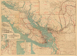
Part contains a commercial and visitors map of the southwestern land districts of British Columbia, encompassing Vancouver Island and the mainland from Seymour Inlet in the northwest to Black Pines in the northeast, extending south to Chiwaukum, Washington. Primary map shows settlements, government agent offices, mining and sub-mining recording offices, game reserves, customs posts, hospitals, ferries, campsites, golf courses, canneries, commercial air harbours, lighthouses, radio stations, motor boat refill stations, power sites, railways, roadways, trails, telegraph and telephone lines, steamship routes, topographic contour lines, and locations of falls and rapids. Text on the map provides information on land features and the presence of wild and farmed animals, and indicates current and possbile agricultural and industrial land use. Inset maps show the northern tip of Vancouver Island, Triangle Island and West and East Haycock Islands, and northwestern Washington State from Seattle to Centralia. A key map shows the location of the area covered by the main map in relation to the rest of North America.
![View on the Chuckanut Drive, Pacific Hiway [Highway]](/uploads/r/null/b/6/0/b6025b13309e21bdb54af6e223a16ae7ab6bf53a3d09a2def09a8c93166d0ea5/dd783a7b-beab-4ff7-bad9-301024b32a21-CVA289-003_142.jpg)
View on the Chuckanut Drive, Pacific Hiway [Highway]
Part of William Orson Banfield fonds
![View on the Chuckanut Drive, Pacific Hiway [Highway]](/uploads/r/null/4/d/0/4d058fcb9f0d5b32ed97fd9c5af0e35e8283cc8b152eafdd34d5578209db5363/41e49344-b986-472a-9e9e-408f242cb37d-CVA289-003_142.jpg)
View on the Chuckanut Drive, Pacific Hiway [Highway]
Part of William Orson Banfield fonds
![View on the Chuckanut Drive, Pacific Hiway [Highway]](/uploads/r/null/8/a/1/8a1138124e805230ee4e02a2286badfe44ff977e5a46f86409a07f8161f7aa71/cd291a91-4ce1-4e1f-8aeb-db5917ba39b1-CVA289-003_142.jpg)
View on the Chuckanut Drive, Pacific Hiway [Highway]
Part of William Orson Banfield fonds
![The road at summit [of] Blewet Pass](/uploads/r/null/8/7/a/87af9a01f91e6a639af597d399c2e04b941e6bb36f49e35531f96a2c196a342f/6eb5986e-f3e3-4be3-8663-3b8cfd485586-CVA289-004_142.jpg)
The road at summit [of] Blewet Pass
Part of William Orson Banfield fonds
![[Columbia Gorge Hotel] and garden](/uploads/r/null/e/e/2/ee2003be0ffaf1d109c4a8fc42712c58d3411c739f7509ef851cd46f055fb8f2/f39d9893-f052-4b8e-a999-d012268b5c59-CVA289-004_142.jpg)
[Columbia Gorge Hotel] and garden
Part of William Orson Banfield fonds
![Cloud Cap Inn, M[oun]t Hood](/uploads/r/null/c/3/1/c312ea1285c10b4806d007ac20223e4d5e45ff822506f5a5913446df5899e1bc/bb39cd62-e9bf-449a-b9bc-4050c2712672-CVA289-004_142.jpg)
Part of William Orson Banfield fonds
![M[oun]t Hood](/uploads/r/null/f/f/a/ffa40e15d75e58107cf469529306b57965f1d07e8852c92312aa0e657790e20d/f2d5e63d-7a89-4e1d-a7ba-7d56f8254194-CVA289-004_142.jpg)
Part of William Orson Banfield fonds

Part of William Orson Banfield fonds

Part of William Orson Banfield fonds

Part of William Orson Banfield fonds

Part of William Orson Banfield fonds
![[Beatrice Timmins beside automobile] just leaving Columbia Gorge Hotel](/uploads/r/null/f/5/2/f52309338643c938f01b243a270b195cc01934bf17fc9427d889055de1f718ff/b64e2510-0e86-483c-80c6-74d7a9497090-CVA289-004_142.jpg)
[Beatrice Timmins beside automobile] just leaving Columbia Gorge Hotel
Part of William Orson Banfield fonds

Columbia River at the Cascades
Part of William Orson Banfield fonds

Part of William Orson Banfield fonds

Part of William Orson Banfield fonds

Part of William Orson Banfield fonds

Two Lakes reflection and Louise
Part of William Orson Banfield fonds

Part of William Orson Banfield fonds

Part of William Orson Banfield fonds

Part of William Orson Banfield fonds

Part of William Orson Banfield fonds
![M[oun]t Hood](/uploads/r/null/0/2/0/02028d2eea4c03f2b9373d0e49541197272d29af8af48e698502643baf0e03c0/fb72e5f8-288e-49df-919e-c54e36b5d4f9-CVA289-004_142.jpg)
Part of William Orson Banfield fonds

A falls on Columbia River Hiway
Part of William Orson Banfield fonds

Part of William Orson Banfield fonds

Part of William Orson Banfield fonds
A timber flume near Hood River
Part of William Orson Banfield fonds
![M[oun]t Hood from Cloud Cap Inn](/uploads/r/null/2/6/9/269c54a2cff178fca9ab040b6ac521a828671e22d056a8f7c504cc188f657369/373abcd8-cd58-4da3-9943-5745f7130f6e-CVA289-004_142.jpg)
M[oun]t Hood from Cloud Cap Inn
Part of William Orson Banfield fonds
Part of William Orson Banfield fonds

Part of William Orson Banfield fonds

Part of William Orson Banfield fonds
Item is a photograph showing Beatrice Timmins feeding a bear at a roadside.
![M[oun]t Shuskan from Table M[ountain]](/uploads/r/null/0/3/4/0340750cdde3066bad0daffa38e79a47c10aeb20b2d1b0163c56e34c6cbebf70/dd7007b8-b938-4f3d-9d45-fcbe89141044-CVA289-004_142.jpg)
M[oun]t Shuskan from Table M[ountain]
Part of William Orson Banfield fonds
Item is a photograph showing Mount Shuskan with Beatrice Timmins in the foreground.
Item contains a commercial and visitors map of the southwestern land districts of British Columbia on one side and textual information on the region on the other.
![[Beatrice Timmins] on Table M[oun]t[ain]](/uploads/r/null/8/2/d/82db37d9b9fd4aa595e394f944fb6be13512bd87a45ea351d393bede0d1c09f8/86c64f1b-4533-4a75-a529-21b3846d5c03-CVA289-004_142.jpg)
[Beatrice Timmins] on Table M[oun]t[ain]
Part of William Orson Banfield fonds

The Sunrise Lake at Table Mountain
Part of William Orson Banfield fonds
![Table M[oun]t[ain]](/uploads/r/null/9/3/f/93f45b7e77f91c47f5825d46db7a4f7a92ca8db083def523a6c7b348e94d30c5/1125e985-3495-40fc-81b4-81f89ec4fe25-CVA289-004_142.jpg)
Part of William Orson Banfield fonds

Part of William Orson Banfield fonds

Southwestern districts : Map no. 1K : comparative geographical study
Part contains information on the southwestern districts of British Columbia, including population, climate, agriculture, industry, labour, and education; itineraries for exploring the various regions; information on Canadian customs regulations and game regulations; and diagrams of road routes to British Columbia from California and Alberta/western Washington.
Part of City of Vancouver Archives technical and cartographic drawing collection
Item is a sheet with 4 maps on recto and text on verso. The maps depict southwestern British Columbia; the information on the verso is predominantly statistics re: the province's economic development and tourism information for various towns and districts in the area.
Twin Lakes from Mt Winchester, Mt Baker National Forest
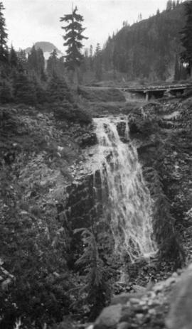
Galena Falls - Mt Baker National Forest

Galena Creek, Mt Baker National Forest Reserve

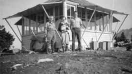
Forestry Lookout, Mt Winchester, Mt Baker National Forest Reserve, Washington
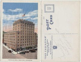
Cascadian Hotel, Wenatchee, Washington

Pentagonal columnar lava near Bogley Lakes, Mt Baker National Forest Reserve, Washington