- AM495-F2-: LEG1283.8
- Item
- Sep. 7, 1943
Item is a street map showing Vancouver, Burnaby, New Westminster, West Vancouver, and North Vancouver on one side and Lulu Island and Sea Island, Delta, Surrey, Langley and Maillardville on the other.
447 results with digital objects Show results with digital objects
Item is a street map showing Vancouver, Burnaby, New Westminster, West Vancouver, and North Vancouver on one side and Lulu Island and Sea Island, Delta, Surrey, Langley and Maillardville on the other.
Dial map of the city of Vancouver including the adjacent municipalities
Item is a street map showing Vancouver, Burnaby, New Westminster, West Vancouver and North Vancouver on one side and the University Endowment Lands, Surrey, Maillardville, Lulu Island and Sea Island on the other.
Part of City of Vancouver Archives technical and cartographic drawing collection
File consists of a booklet of maps advertising the sale of lots in the British Properties development in West Vancouver, B.C. Maps show lot dimensions and purchase price (some lots already listed as sold).


Gleneagles Golf and Country Club

Aerial view of Whytecliff Park

V.N.H.S. Lighthouse Park, 1965
Part of Stuart Thomson fonds

Part of Stuart Thomson fonds

Part of City of Vancouver Archives technical and cartographic drawing collection
Item is a map compiled and drawn by J.S. Matthews, City Archivist showing historic place names of Vancouver and the North Shore and listing some historic Burnaby names. A note in the bottom left hand corner reads: "Memorada. The precise location of "Albert City" is unknown, Narveaz was first; 150 years passed before his name was given to a landmark. His vessel's name "Santa Saturnina" has never been applied to anything at all."
Nomenclature. Indian villages and landmarks, Burrard Inlet and English Bay, before the whiteman came
Part of Major Matthews collection
Item is a map which shows the geographic area bounded by the north shore of Burrard Inlet, the Fraser River, Point Atkinson, and the Burrard Inlet Second Narrows. Physical features on the map (primarily coastal sites) are labeled using both First Nations and European place names.
Matthews, James Skitt, Major

Street Map of Greater Vancouver, B.C.
Part of City of Vancouver Archives technical and cartographic drawing collection
Part consists of the back side of a road map. The main map is a road map of Greater Vancouver; the sheet also includes inset road maps of Coquitlam, West Vancouver, and Highway 99 to Squamish.
![[Great Northern Cannery, West Vancouver]](/uploads/r/null/9/0/90f8d1f7d801a768a392a47d0367fd6b963ada1e8f0174d40dd235af797a95db/81acecd3-098a-4747-b6af-830576750bbb-A04597_142.jpg)
[Great Northern Cannery, West Vancouver]
Part of Major Matthews collection
J.S. Matthews' notes with print or negative in Archives.
![[View of West Vancouver from Prospect Point]](/uploads/r/null/0/5/051c963366583e6b30846e1a25d81e8b8df434dbc69baf68d92b559ea38b5a40/1832ce63-26ab-4b5e-86c2-95c22cdfccf5-A04482_142.jpg)
[View of West Vancouver from Prospect Point]
Part of Major Matthews collection
J.S. Matthews' notes with print or negative in Archives.
![[West Vancouver Ferries]](/uploads/r/null/3/8/382ad792d58b296f1df786b0e2e2f415697e00f78ea99bef117688f481868dc8/628b9cda-6e8d-4941-b231-3a25fd11cd71-A16520_142.jpg)
Part of City of Vancouver fonds
George Fitch residence :[906 Campbell, West Vancouver?]
Part of C.B.K. Van Norman fonds
File consists of the following types of architectural drawings: elevations, floor plans and structural specifications.

Photograph shows the Union Steamer "Comox"

View looking out to Point Grey, from North Shore, Marine Drive, Vancouver, B.C., Canada

The picturesque North Shore at Fisherman's Cove, Vancouver, B.C., Canada

Point Atkinson Light House and Point Grey

Item is a postcard printed with a reproduction of a painting of Peppi's Restaurant in Dundarave, West Vancouver, B.C.
![[Point Atkinson Lighthouse, West Vancouver, B.C.]](/uploads/r/null/8/1/0/810ea423294b64b722f9557bc340cde9dd009bca5f1f42e6203130d3e038b28e/8eb82af4-c24c-4872-98ec-b839cfb7ae51-AM1052P-847_142.jpg)
[Point Atkinson Lighthouse, West Vancouver, B.C.]

The picturesque North Shore, at Fisherman's Cove
This postcard includes personal correspondence. Sent to Miss Mary Hudson of Moorecroft, Nanoose Bay, Vancouver Island, B.C.

Photograph shows cliffs, the road, the sea, and other features
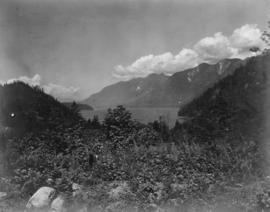
Photograph shows mountain range and ocean.

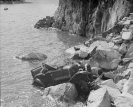
Photograph shows a car parked at the bend of a dirt road, with the cliff on one side and the sea on the other.

Photograph shows two cars parked on road with cliffs on either side and the sea in the horizon.
Greater Vancouver Water supply area (West Vancouver, B.C.)
Plan of right of way : PGE Railway Company (West Vancouver, B.C.)
Municipality of West Burnaby (West Vancouver, B.C.)
Subdivision and land use (West Vancouver, B.C.)
Slopes : North Shore (West Vancouver, B.C.)
Subdivision and land use : residential analysis (West Vancouver, B.C.)
Subdivision and land use (West Vancouver, B.C.)

Photograph shows a sign promoting bond sales in West Vancouver
![Lions Gate Bridge, Vancouver [-] C.P.R. steamer on triangle run between Seattle, U.S.A.[,] Victor...](/uploads/r/null/5/d/1/5d183c2953996f476cd62a6b726fc98802c366915c77ff6085698dd4bc8adf2f/37665d50-9ad5-4863-adb7-6bc7737a80a2-AM1052P-172_142.jpg)
Item is a postcard printed with an image of a Canadian Pacific Railway Company steamship passing under the Lions Gate Bridge on its way into Vancouver. The vantage point for this image was at Stanley Park.

Item is a postcard printed with an image of one of the Canadian Pacific Railway Company's coastal service steamships, the Princess Patricia, passing under the Lions Gate Bridge.
![C.P.R. Princess Patricia[.] On triangle run between Seattle, U.S.A., Victoria and Vancouver, Canada.](/uploads/r/null/f/b/7/fb7441754f9fc1d275437a1d5193eb3118f843dff409135ac47ec5582f404c41/44aaa029-cad1-4e68-b7d1-9cec0fbe7e7b-AM1052P-153_142.jpg)
C.P.R. Princess Patricia[.] On triangle run between Seattle, U.S.A., Victoria and Vancouver, Canada.
Item is a postcard printed with an image of the Princess Patricia, one of the Canadian Pacific Railway Company's coastal service steamships, passing under the Lions Gate Bridge.

Item is a postcard printed with an image of the Lions Gate Bridge at nightfall, viewed from Stanley Park and looking north toward West Vancouver.
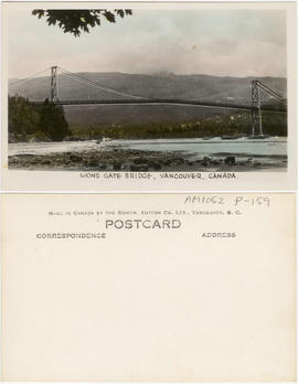
Lions Gate Bridge, Vancouver, Canada
Item is a postcard printed with an image of the Lions Gate Bridge and West Vancouver as viewed from a point near Lumberman's Arch in Stanley Park. The seawall around Stanley Park is shown in the lower left corner of the image.
!["Johnson Line". M/S Lions Gate [at First Narrows]](/uploads/r/null/1/a/d/1ad294094520eb6c9c1f07342514f0dbaf0cb2efb1338c392559c94447612d77/d363d26f-d9e1-4f80-ba53-00d09133aeda-AM1052P-151_142.jpg)
"Johnson Line". M/S Lions Gate [at First Narrows]
Item is a postcard printed with an image of the Lions Gate, a passenger ship owned and operated by the Swedish company Johnson Line. The ship is pictured on its way out of Burrard Inlet. The Capilano Fog and Light Station and the mouth of the Capilano River are shown.
![[Group portrait of a Sea Cadets class at Whytecliffe]](/uploads/r/null/7/d/7d238b2baef3223282981a98127f23a747ef4c88a78732898186b0561cd7650a/d55c50cc-08ad-4f5c-bdf1-747aab03e0db-A11154_142.jpg)
[Group portrait of a Sea Cadets class at Whytecliffe]
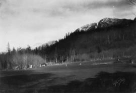
![A.R.P. [drill]](/uploads/r/null/2/a/2a0eef3b13982ade27dd50144e8caa6e01bbe549307544f384b293e29b061a96/e4d3d45e-c74a-4cb0-831e-6892a9c7c381-A07443_142.jpg)
![A.R.P. [reviewing stand at drill]](/uploads/r/null/0/8/0827637fe55bd1da884a002fa4c9e4654f3b7fa1314e064d0778b262b4e52001/70fa59b1-7aa5-4058-b419-223a9d7afa11-A07442_142.jpg)
A.R.P. [reviewing stand at drill]
![A.R.P. [first aid drill]](/uploads/r/null/d/a/daa2a04454f2bad610d19508771742b7a97674449f39c022340348b93ecfee07/f9c519d6-943b-40c6-9f57-bd4a51d47f5c-A07441_142.jpg)
![A.R.P. [drill]](/uploads/r/null/4/f/4f092ff8c252ed3b3ed04017d7a52a800abecff1743e615995ee40ab5549b162/0e52d1df-e943-4e3a-9132-6cca8a47658e-A07440_142.jpg)