
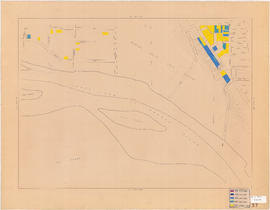
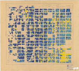
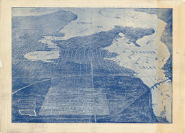
Age of buildings : Arbutus Street to Oak Street and Broadway to King Edward Avenue
- COV-S445-3-: LEG1221.1-: LEG1221.1.25
- Part
- 1954
Part of City of Vancouver fonds
504 results with digital objects Show results with digital objects
Age of buildings : Arbutus Street to Oak Street and Broadway to King Edward Avenue
Part of City of Vancouver fonds

Age of buildings : Maple Street to Oak Street and 41st Avenue to 57th Avenue
Part of City of Vancouver fonds

Age of buildings : Slocan Street to Boundary Road and 5th Avenue to 22nd Avenue
Part of City of Vancouver fonds

Age of buildings : Arbutus Street/S.W. Marine Drive to Fremlin Street and 57th Avenue to 72nd Avenue
Part of City of Vancouver fonds

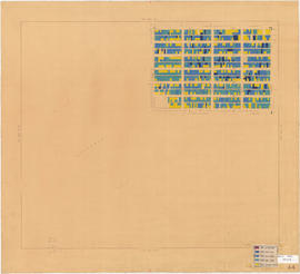
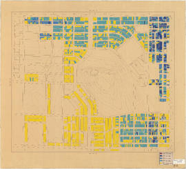
Age of buildings : Granville Street to Fremlin Street and 72nd Avenue to 75th Avenue
Part of City of Vancouver fonds
Annotations show date of construction of buildings for the area bounded by Granville Street, Fremlin Street, 72nd Avenue, and 75th Avenue. Base map shows the area bounded by Angus Drive, Cambie Street, 63rd Avenue, and the North Arm of the Fraser River.

Age of buildings : Blenheim Street to Arbutus Street and Broadway to King Edward Avenue
Part of City of Vancouver fonds

Age of buildings : Blenheim Street to Arbutus Street and Point Grey Road to Broadway
Part of City of Vancouver fonds
Part of City of Vancouver fonds
Age of buildings : Blenheim Street to Maple Street/Laburnum Street and 41st Avenue to 57th Avenue
Part of City of Vancouver fonds

Age of buildings : Blenheim Street to Maple Street and King Edward Avenue to 41st Avenue
Part of City of Vancouver fonds

Age of buildings : Crown Street to Blenheim Street and 41st Avenue to 55th Avenue
Part of City of Vancouver fonds

Age of buildings : Discovery Street to Blenheim Street and Point Grey Road to 10th Avenue
Part of City of Vancouver fonds

Age of buildings : Discovery Street to Blenheim Street and 10th Avenue to King Edward Avenue
Part of City of Vancouver fonds
Age of buildings : Camosun Street to Blenheim Street and King Edward Avenue to 41st Avenue
Part of City of Vancouver fonds
Age of buildings : Blanca Street to Discovery Street and 10th Avenue to 16th Avenue
Part of City of Vancouver fonds

Age of buildings : Slocan Street to Boundary Road and 22nd Avenue to Kingsway
Part of City of Vancouver fonds

Age of buildings : University Endowment Lands to Discovery Street and Hadden Avenue to 10th Avenue
Part of City of Vancouver fonds
Age of buildings : Clark Drive to Slocan Street and Hastings Street to 6th Avenue
Part of City of Vancouver fonds

Part of City of Vancouver fonds
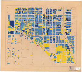
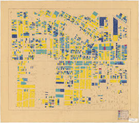
Age of buildings : Oak Street to Main Street and King Edward Avenue to 41st Avenue
Part of City of Vancouver fonds
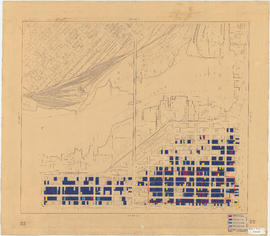
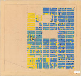
Age of buildings : Oak Street to Main Street and 6th Avenue/2nd Avenue to Broadway
Part of City of Vancouver fonds
Annotations show date of construction of buildings for the area bounded by Oak Street, Main Street, 6th and 2nd Avenues, and Broadway. Base map extends north to Davie Street at Hornby Street in the northwest and Union Street at Main Street in the northeast. The area extending from Yukon Street to Main Street and 6th Avenue to Broadway is outlined; the significance of the outline is unknown.

Age of buildings : Clark Drive to Slocan Street and Powell Street/Wall Street to Hastings Street
Part of City of Vancouver fonds
Age of buildings : Wales Street/Vivian Street to Boundary Road and Kingsway to 52nd Avenue
Part of City of Vancouver fonds

Age of buildings : Vivian Street to Boundary Road and 52nd Avenue to S.E. Marine Drive
Part of City of Vancouver fonds

Age of buildings : Knight Street to Slocan Street/Wales Street and 22nd Avenue to 37th Avenue
Part of City of Vancouver fonds

Age of buildings : Clark Drive/Knight Street to Slocan Street and 6th Avenue to 22nd Avenue
Part of City of Vancouver fonds

Part consists of a street map of Vancouver showing block numbers, street car, bus, and railway lines, parks and hospitals. Map includes a dial (a numbered circle, a paper indicator, a grid of block numbers and a street index used to find locations).

Map of City of Vancouver, British Columbia
Map shows streets, schools, hospitals, street car lines, railways and address block numbers in Vancouver.

Vest pocket map of Vancouver : map C
Part of City of Vancouver Archives technical and cartographic drawing collection
Part shows Vancouver from Boundary Street (Alma Street) to Heather Street and English Bay/False Creek to Sixteenth Avenue west of Boundary Street (Trafalgar Street) and to Ninth Avenue (Broadway) east of Vine Street. Shows district lot and block numbers, public schools, and hospitals.

Vest pocket map of Vancouver : map D
Part of City of Vancouver Archives technical and cartographic drawing collection
Part shows Vancouver from Heather Street to Garden Drive and Grant Street to Sixteenth Avenue. Shows district lot and block numbers, public schools, and hospitals.

Part of City of Vancouver Archives technical and cartographic drawing collection
Part is a map showing Vancouver including Point Grey, Hastings Townsite, and part of South Vancouver. Map shows streets, street car routes, neighbourhoods, and distances from City Hall.

Vest pocket map of Vancouver : map B
Part of City of Vancouver Archives technical and cartographic drawing collection
Part shows Vancouver from Westminster Avenue (Main Street) to Garden Drive and Burrard Inlet to Grant Street. Shows district lot and block numbers, public schools, and hospitals.

Part of City of Vancouver Archives technical and cartographic drawing collection
Part contains a street map of Vancouver showing streets, block numbers, bus routes, railway lines, boundaries, private roads and hospitals. The map includes a dial (a numbered circle, a paper indicator, a grid of block numbers and a street index used to find locations in Vancouver). A small inset shows the streets surrounding Queen Elizabeth Park, which are obscured on the main map where the indicator is attached.

Dial map of Greater Vancouver and suburbs
Part of City of Vancouver Archives technical and cartographic drawing collection
Part contains a street map of Vancouver, Burnaby, New Westminster, West Vancouver, and North Vancouver showing railways, hospitals, parks and block numbers. The map includes two dials (numbered circles, paper indicators, a grid of block numbers and a street index used to find locations).

Dial map of Greater Vancouver and suburbs
Part of City of Vancouver Archives technical and cartographic drawing collection
Part contains a street map of Vancouver, Burnaby, New Westminster, West Vancouver and North Vancouver showing block numbers, street car, bus, and railway lines, parks and hospitals. Map includes two dials (a numbered circle, a paper indicator, a grid of block numbers and a street index used to find locations). A small inset map shows the Capitol Hill/Scenic Park area of Burnaby in greater detail.

Champlain Heights : D.L. 334, group one, N.W.D.
Part of City of Vancouver Archives technical and cartographic drawing collection
Part is a map showing lot numbers, lot sizes, lot values and sidewalk crossings in the area from Rosemont Drive in the north to 63rd Avenue in the south and from Butler Street in the east to Kerr Street in the west.

City of Vancouver : Canadian Pacific town site
Part of City of Vancouver Archives technical and cartographic drawing collection
Part contains four maps. The main map shows district lots and block numbers in Vancouver from Vine Street in the west to Boundary Avenue (Glen Drive) in the east and Stanley Park in the north to 9th Avenue (Broadway) in the south. Three smaller maps include an index plan to district lots in Vancouver, South Vancouver, New Westminster, and Burnaby; a world map showing Canadian Pacific mail steamship lines; and an index plan of Vancouver city limits.

Part of City of Vancouver Archives technical and cartographic drawing collection
Part contains an illustrated map of Greater Vancouver showing major streets and tourist attractions.

City of Vancouver, British Columbia : zoning diagram
Part of City of Vancouver Archives technical and cartographic drawing collection
Part contains a zoning map showing city streets, residential, apartment, commercial and industrial districts, as well as parkways and open spaces. Concentric circles spaced a mile apart on the map emanate from a point in downtown Vancouver.

Map of City of Vancouver, British Columbia
Part of City of Vancouver Archives technical and cartographic drawing collection
Part contains a zoning map showing city streets, residential, apartment, commercial and industrial districts, as well as City-owned parks and golf courses. Concentric circles spaced a mile apart on the map emanate from a point in downtown Vancouver.

Greater Vancouver votes October 17th : know your ward - know your poll
Part of City of Vancouver Archives technical and cartographic drawing collection
Part contains a map showing ward and poll numbers and locations in the City of Vancouver from Burrard Inlet in the north to the Fraser River in the south and from Boundary Road in the east to Blanca in the west.

Part of City of Vancouver Archives technical and cartographic drawing collection
Part contains a map of East Vancouver Heights showing streets, block numbers and lot numbers, an index map showing the location of East Vancouver Heights in relation to the rest of the city, and text promoting the area.

Greater Vancouver votes October 17th : know your ward - know your poll
Part of City of Vancouver Archives technical and cartographic drawing collection
Part contains a map showing ward and poll numbers and locations in the City of Vancouver from Burrard Inlet in the north to the Fraser River in the south and from Boundary Road in the east to Blanca in the west. Map has been annotated by Major J.S. Matthews to show mayoralty election results by ward.
Bird's eye view of Vancouver, B.C.
Part of City of Vancouver Archives technical and cartographic drawing collection
Part contains an illustrated oblique view of Vancouver showing steamship lines, bridges, beaches, major roads, and the location and block numbers of East Vancouver Heights.

Part of City of Vancouver Archives technical and cartographic drawing collection
Part contains a map showing block and lot numbers of properties in the area bounded by Campbell Street (Alma Street), Richards Street (Balaclava Street), English Bay, and present-day 15th Avenue (not named on map).

Indexed map of Greater Vancouver showing distances from Bekins building
Part of City of Vancouver Archives technical and cartographic drawing collection

Part of City of Vancouver Archives technical and cartographic drawing collection
Part contains a map showing street car, interurban, and motor bus lines in from Vancouver to New Westminster, a map showing existing and projected power plants near Alouette and Stave Lakes, and a profile showing the existing and proposed plants.

Part of City of Vancouver Archives technical and cartographic drawing collection
Part contains maps of the Richmond and downtown Vancouver transit systems, a street index to the Greater Vancouver map on the other side of the sheet, information on B.C. Electric transit routes, and general tourist information.

Street map of Greater Vancouver showing distances from Bekins building
Part of City of Vancouver Archives technical and cartographic drawing collection

Part of City of Vancouver Archives technical and cartographic drawing collection
Part contains maps of the Richmond and downtown Vancouver transit systems, a street index to the Greater Vancouver map on the other side of the sheet, information on B.C. Electric transit routes, and general tourist information.