![[Swimming and canoeing at] English Bay](/uploads/r/null/9/a/8/9a818780614faf64f7b257e62f71ee685d9fdc5856622f94f8d3c04a2961d19b/c56c052b-4774-4813-9464-0b5e97bed44e-CVA242-10_142.jpg)
[Swimming and canoeing at] English Bay
- AM624-S1-F1-: CVA 242-10.05
- Item
- 1901
Part of Olga Jenkinson Bell fonds
114 results with digital objects Show results with digital objects
[Swimming and canoeing at] English Bay
Part of Olga Jenkinson Bell fonds
![English Bay [beach scene]](/uploads/r/null/4/2/0/420fe931e218beab29c20a02edce235c626166946b5a88b92c7a18763f483196/c4a449c3-b181-4748-8b7b-de6e145c4abd-CVA242-10_142.jpg)
Part of Olga Jenkinson Bell fonds
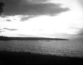
Sunset from English Bay looking towards Point Grey

Harry F. Critchley at English Bay
Item is a photograph showing Harry F. Critchley, as a boy, sitting on the English Bay beach, with the pier and Englesea Lodge in the distance.

Daughter and Son-in-law of A.B. Sayer Smith, at English Bay, near Alexandra Park
View of English Bay from A.B. Sayer Smith property near Chilco and Beach Avenue

Olsen family picnic at English Bay
Part of William Olsen fonds

Part of Alexander Godfrey fonds

Mr. and Mrs. Norman Caple at English Bay, Beach Avenue

Fork lift truck clearing the beach at English Bay in preparation for summer
Part of Vancouver Express fonds
Item is a photograph showing a fork lift truck clearing the beach at English Bay in preparation for summer. Caption from Vancouver Express: Spring cleaning is a must, even for the city's beaches. Winds and high tides of winter shift logs and other debris onto the sands. Here a fork lift truck makes sure English Bay will be clear for summer swimmers."

Robert Marrion with two friends at English Bay.
Item is a photograph of (L-R): Robert Marrion, Harry Williams and Billy Shat wearing towels at English Bay.

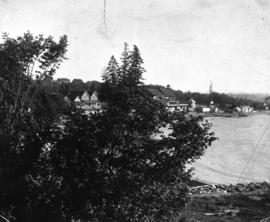
Robert Marrion's summer cottages, English Bay Beach. "Marrion's Rock" in foreground.
Item is a photograph of Robert Marrion's summer cottages at English Bay beach. Annotation on verso: "These cottages were built by Mr. Robb. Marrion at English Bay around 1890. The rock in the foreground was known as Marrion's Rock."
File contains a photograph album showing various scenes of Vancouver and the surrounding area. Places include: Stanley Park, English Bay, Hastings Park, North Vancouver (Capilano Canyon, Seymour Creek Canyon, Lynn Creek Canyon), mouth of the Fraser River, Howe Sound, Burrard Inlet. There are also photographs of various ships around Vancouver. All photographs have caption hand written below.

Mayoral parties and distinguished citizens cruise around English Bay on board "Fispa"

Vancouver's First Aquarium plaque
Part of City of Vancouver fonds
Item is a photograph of a plaque donated by Ivar's Corporation of Seattle recognizing Vancouver's first aquarium and its owner and operator, Ivar Haglund.
Vancouver's First Aquarium plaque
Part of City of Vancouver fonds
Item is a photograph of a plaque donated by Ivar's Corporation of Seattle recognizing Vancouver's first aquarium and its owner and operator, Ivar Haglund.

Vancouver's First Aquarium plaque
Part of City of Vancouver fonds
Item is a photograph of a plaque donated by Ivar's Corporation of Seattle recognizing Vancouver's first aquarium and its owner and operator, Ivar Haglund.

English Bay Bathhouse before repainting
Part of City of Vancouver fonds

English Bay Bathhouse before repainting
Part of City of Vancouver fonds
Inukshuk site proposal at English Bay
Part of City of Vancouver fonds

Inukshuk site proposal at English Bay
Part of City of Vancouver fonds

English Bay Bathhouse before repainting
Part of City of Vancouver fonds

English Bay Bathhouse after repainting
Part of City of Vancouver fonds

Part of City of Vancouver fonds


Vancouver Harbour, British Columbia
Part of City of Vancouver Archives technical and cartographic drawing collection
Item is a nautical chart of Burrard Inlet, including the southern portions of the North Arm of Burrard Inlet. The map shows depth soundings, harbour anchorages, headlines, beacons, buoys, bells, piers and wharves. The map also shows lot numbers, municipal boundaries and major street names of the southern portion of North Vancouver and the northern portions of Point Grey, Kitsilano, Mt. Pleasant, Fairview, Hastings Townsite, Burnaby and Port Moody from the Coquitlam municipal boundary in the east to the western boundary of the Vancouver harbour (between Point Atkinson and Point Grey) in the west. The item also includes a key map showing the location of the Vancouver Harbour in relation to northwestern Washington and Vancouver Island and an inset map showing lots surrounding the north arm of Burrard Inlet to the Inlailawatash Indian Reserve.

People dressed in Expo '86 turtle costumes at Polar Bear Swim
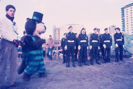
Tillicum with youth in uniform on beach at Polar Bear Swim

Tillicum and fitness instructors lead group exercise from Chevron Stage at Polar Bear Swim
Tillicum interacting with attendee at Polar Bear Swim
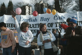
Centennial commissioners in front of English Bay Café banner at Polar Bear Swim

Musical performance at Polar Bear Swim
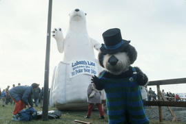
Tillicum posing in front of inflatable polar bear at Polar Bear Swim
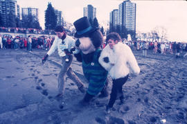
Tillicum walking on beach with man and woman at Polar Bear Swim

Tillicum walking on beach with man and woman at Polar Bear Swim

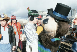
Tillicum interacting with Polar Bear Swim attendees
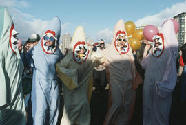
Group dressed in shark costumes at Polar Bear Swim
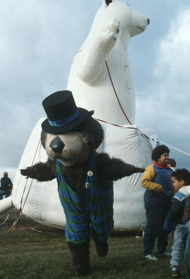
Tillicum posing in front of inflatable polar bear at Polar Bear Swim

Tillicum interacting with Polar Bear Swim attendees

Commissioner, police officer and man on beach at Polar Bear Swim

Crowd on the beach during Polar Bear Swim
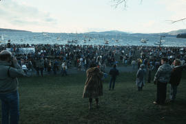
Crowd on the beach during Polar Bear Swim
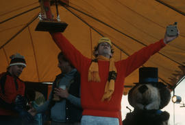
Man holding awards on stage at Polar Bear Swim

Man holding awards on stage at Polar Bear Swim

Four men on stage at Polar Bear Swim
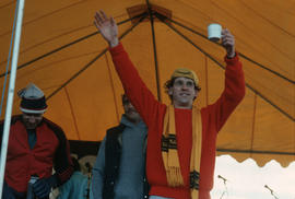
Men on stage at Polar Bear Swim
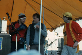
Men on stage at Polar Bear Swim

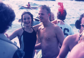
Crowd watching swimmers in water during Polar Bear Swim