
Map of Greater Vancouver and environs showing principal auto roads and highways
- AM1594-: MAP 770b-: LEG1299.4
- Part
- 1927
Part of City of Vancouver Archives technical and cartographic drawing collection
58 results with digital objects Show results with digital objects
Map of Greater Vancouver and environs showing principal auto roads and highways
Part of City of Vancouver Archives technical and cartographic drawing collection

Map of Greater Vancouver and environs showing principal auto roads and highways
Part of City of Vancouver Archives technical and cartographic drawing collection

Map of Greater Vancouver and environs showing principal auto roads and highways
Part of City of Vancouver Archives technical and cartographic drawing collection
Part contains a map of Greater Vancouver showing major roads, parks, lakes, mountains, beaches, and distances from the post office.
Map of Greater Vancouver and Lower Mainland area
Part of City of Vancouver Archives technical and cartographic drawing collection
Item is a brochure with various street maps of Greater Vancouver, folded and enclosed in an attached folder with promotional material on the Vancouver Real Estate Board and information on sites of interest in the area.
Part of City of Vancouver Archives technical and cartographic drawing collection
Item is a pamphlet containing a street map of Greater Vancouver, an illustrated map of West Vancouver and North Vancouver, and real estate information including the benefits of owning versus renting real property.

Part of City of Vancouver Archives technical and cartographic drawing collection
Part contains a map showing trunk sewers and drains constructed, facilities under design and/or construction, pumping stations and sewage treatment plants in the Greater Vancouver area.

Map of Greater Vancouver Water District
Part of City of Vancouver Archives technical and cartographic drawing collection

Map of New Westminster District, B.C
Part of City of Vancouver Archives technical and cartographic drawing collection
Item is a map showing District Lots in Vancouver, and township/range designations in other areas. The map also shows False Creek Trail, North Arm Road, False Creek Road, Granville Road from Granville to Hastings, New Westminster and Burrard Inlet Road, North Road, Semiahmoo Road, New Westminster and Yale Wagon Road, and others. Annotated by W. E. Graveley, 1885, to show additional features including Kingsway, Haney, Albion Camp, etc.
Map of railway freight lines operated by British Columbia Hydro and Power Authority
Part of City of Vancouver Archives technical and cartographic drawing collection
Item is a map showing the B.C. Electric railway (including the Vancouver and Lulu Island branch), other railways, interchange points and municipal city boundaries. Map is designed to be folded in two; cover on verso.
Map of the Fraser Valley showing railway lines and district lots
Part of City of Vancouver Archives technical and cartographic drawing collection
Item contains a map of the Fraser Valley showing railway lines and district lots on one side and text advertising the British Columbia Electric Railway Company's interurban lines on the other.
Map of Vancouver, B.C., and vicinity
Part of City of Vancouver Archives technical and cartographic drawing collection
Item contains a map of Greater Vancouver showing major roads on one side, and a map of downtown Vancouver showing businesses on the other. Text surrounding the map of downtown gives facts about British Columbia, lists principal buildings in Vancouver and provides information about the development of the City of Vancouver.

Part of City of Vancouver Archives technical and cartographic drawing collection
Part contains a map of Greater Vancouver showing the locations of Bekins Moving and Storage, distances from the Burrard Street and York Street location and city streets. Part includes four photographic images of points of interest in Vancouver.

Map of Vancouver, Burnaby, New Westminster, British Columbia : street index and advertisements
Part of City of Vancouver Archives technical and cartographic drawing collection
Part contains a street index for the main map of Vancouver on the other side of the sheet, advertisements for Bekins Moving and Storage and Allied Van Lines, and three maps showing the companies' service areas in the United States, Canada, and British Columbia and Alberta. An annotation reads: "Oppenheimer collection."
![McRoberts Island [Sea Island]](/uploads/r/null/6/9/6981a571c6d3102ee36ac270cce0eca9727531a3a9b4dd09f46f6f61adbbadbe/b8c696f2-5181-4f84-9e76-6420f9b2e916-Map800_142.jpg)
Part of City of Vancouver Archives technical and cartographic drawing collection
Item is a map of McRoberts Island (now named Sea Island). The map shows the locations of farms and the Vancouver Airport, notes on flora and geographical features, crops & dates/partitions of settlement.
Matthews, James Skitt, Major
Metropolitan areas of Vancouver and Victoria, B.C. road map
Part of City of Vancouver Archives technical and cartographic drawing collection
Item is road map designed to be folded into a pamphlet and containing three maps showing streets in Greater Vancouver, major roads from the North Shore to Bellingham, Washington, and major roads in and around Victoria. Item also includes information about traffic rules in Vancouver and the use of the imperial gallon in British Columbia.

Part of City of Vancouver Archives technical and cartographic drawing collection
Part contains a map showing major roads from the North Shore to Bellingham, Washington; a map showing major roads in the Victoria area from Cobble Hill in the northwest to Sooke in the southwest; and traffic rules for Vancouver.

Part of City of Vancouver Archives technical and cartographic drawing collection
Item is a map showing the locations and names of major businesses and corporations in the Greater Vancouver area. The map also shows major roads, highways, railways and proposed highway routes. 5 mile and 10 mile radius circles are depicted around the "geographical centre of metropolitan Vancouver." Map background is a mosaic of aerial photographs.

Part of City of Vancouver Archives technical and cartographic drawing collection
Item is a map showing topography, roads, trails, railways, bridges, boundaries, reserves, power lines, telephone lines, triangulation stations, camera stations, bench marks, houses, barns, mills, factories, schools, churches, post offices, telephone exchanges, mines and geographic features in the Pitt Meadows area and extending south through Cloverdale and Langley to the United States border. A small index map shows the area covered by the primary map in relation to other maps in the series.

Part of City of Vancouver Archives technical and cartographic drawing collection
Item is a map showing topography, roads, trails, railways, bridges, boundaries, reserves, power lines, telephone lines, triangulation stations, camera stations, bench marks, houses, barns, mills, factories, schools, churches, post offices, telephone exchanges, mines and geographic features in the area of South Burnaby and New Westminster, extending south through Surrey and White Rock to the United States border. A small index map shows the area covered by the primary map in relation to other maps in the series.

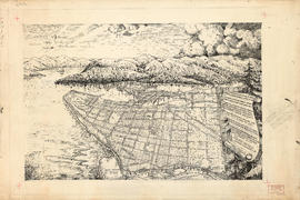
Perspective of Greater Vancouver from Grouse Mountain (elevation 4000 ft.)
Part of City of Vancouver Archives technical and cartographic drawing collection
item is an illustrated, map-like pictorial view of Greater Vancouver. Locations of districts, waterways, beaches, golf courses, principal parks and significant buildings are identified by matching an index list to corresponding letters and numbers on the vertical and horizontal axes along the border of the map.
Pictorial map of Greater Vancouver
Part of City of Vancouver Archives technical and cartographic drawing collection
Part contains an illustrated map (not drawn to scale) of Vancouver and the surrounding area and a celebratory poem. An annotation at the edge of the drawing proposes inverting two lines of the poem.

Part of City of Vancouver Archives technical and cartographic drawing collection
Part is an overlay designed to be used with a pictorial map of Greater Vancouver to show key dates in various areas.

Part of City of Vancouver Archives technical and cartographic drawing collection
Item consists of an illustrated map of the Vancouver area and an overlay showing dates of settlement in various areas and the opening dates of regional landmarks. A poem about the growth of Vancouver has been included on the right-hand side of the map. Verso contains a seemingly unrelated drawing dated 1911 and showing front and side elevations for a church building.

Plan of Greater Vancouver, British Columbia
Part of City of Vancouver Archives technical and cartographic drawing collection
Item is a map of Greater Vancouver from Alma Road (Alma Street) to Boundary Road and Burrard Inlet to King Edward Avenue. Map shows district lot, block, and lot numbers, waterfront businesses, rail lines, schools, parks, beaches, and concentric circles indicating distances from a point located approximately at the intersection of Cambie and Hastings Streets.

Principal freight railway facilities of British Columbia Hydro and Power Authority
Part of City of Vancouver Archives technical and cartographic drawing collection
Part contains a map showing the B.C. Electric railway (including the Vancouver and Lulu Island branch), other railways, interchange points and municipal city boundaries.
Provincial electoral districts
Part of City of Vancouver Archives technical and cartographic drawing collection
Item is a map which shows the boundaries of provincial electoral districts in the Lower Mainland and in Greater Victoria.
Railroad map of Greater Vancouver, British Columbia
Part of City of Vancouver Archives technical and cartographic drawing collection
Item is a map depicting existing, abandoned and proposed railroad lines in Greater Vancouver from the late 1800's to 1970. Information about the construction and de-commissioning of lines is provided. The map legend indicates important dates in Canadian railroad history.

Railroad map of Greater Vancouver, British Columbia
Part of City of Vancouver Archives technical and cartographic drawing collection
Item is a map which shows the routes of the Great Northern Railway, the Burlington Northern Railway, the Canadian Northern Pacific Railway, the British Columbia Electric Railway, the Canadian Pacific Railway, the Canadian National Railway, and the Pacific Great Eastern Railway. The map notes years of railway completion, years of abandonment, existing trackage, abandoned trackage, proposed trackage, tunnel trackage, and important dates.
Railroads of the Lower Mainland of British Columbia
Part of City of Vancouver Archives technical and cartographic drawing collection
Primary map shows railroads, railroad names, subdivisions, spurs or yards, timetable station names, station buildings, absolute signals, signal identities, hot boxes and/or dragging equipment detectors, mileboards, bridges and interchanges in the Greater Vancouver area from West Vancouver in the north to the United States border in the south and from Haney in the east to Horseshoe Bay in the west. Ancillary maps show the B.C. Rail Squamish subdivision, the Vancouver B.N., C.N. and C.P. railroad yards, New Westminster C.N., C.P. and S.R.Y. railroad details, Burlington Northern Brunette details, the Canadian National Thornton Yard and Coquitlam C.P. details.
Railroads of the Lower Mainland of British Columbia, 1882-1992
Part of City of Vancouver Archives technical and cartographic drawing collection
Primary map shows existing track, abandoned track, station buildings and bridges in the Greater Vancouver area from West Vancouver in the north to the United States border in the south and from Haney in the east to Horseshoe Bay in the west. Ancillary maps show details of Vancouver B.C.E., C.No.P., C.P. and G.N. railroad yards and New Westminster B.C.E., C.No.P., C.P. details. The item also includes a chronology of railroad subsidiaries, takeovers and mergers.
Regional road policy . Provincial highways
Part of City of Vancouver Archives technical and cartographic drawing collection
Regional roads policy. Fast bus network
Part of City of Vancouver Archives technical and cartographic drawing collection
Regional roads policy. Municipal truck routes
Part of City of Vancouver Archives technical and cartographic drawing collection
Rights of way Vancouver and vicinity
Part of City of Vancouver Archives technical and cartographic drawing collection
Item is a portion of a topographical map of the Lower Mainland which has been extensively annotated to show the routes and rights-of-way of the various railways running through the region.
The lines shown are: Canadian Pacific Railway, Canadian National Railway, Great Northern Railway, B.C. Electric Railway, Canadian Pacific Railway operated by B.C. Electric Railway, Canadian Pacific Railway joint operation with National Harbours Board Terminal Railway, Great Northern Railway joint operation with National Harbours Board Terminal Railway, Great Northern Railway joint operation with Canadian National Railway, National Harbours Board Terminal Railway and Canadian Pacific Railway tunnel and Pacific Great Eastern Railway lease to National Harbours Board.
Shell map of Vancouver, B.C. and Victoria, B.C.
Part of City of Vancouver Archives technical and cartographic drawing collection
Item is a fold-out street map with Greater Vancouver on one side and Greater Victoria on the other.

Street index of Vancouver and lower mainland
Part of City of Vancouver Archives technical and cartographic drawing collection
Part contains the street index for a map of Greater Vancouver and advertisements for Roy Wrigley Printing and Publishing Co. and A.E. Austin and Co. Limited.
Street map of Greater Vancouver
Part of City of Vancouver Archives technical and cartographic drawing collection
Item is a published road map, created for and distributed by Home Oil Distributors, with a map of Greater Vancouver on one side and maps of the Fraser Valley, Surrey and Richmond (iwth street indexes) on the other. The maps show roads, block numbers, boundaries, highway markers and Home Oil gas stations.

Street map of Greater Vancouver, B.C.
Part of City of Vancouver Archives technical and cartographic drawing collection
Part contains a street map of Greater Vancouver showing block numbers, parks, golf courses, cemeteries, and hospitals; inset maps showing streets in Coquitlam and the Horseshoe Bay area; and a map showing Highway 99 from Horseshoe Bay to Squamish.

Street map of Greater Vancouver, B.C.
Part of City of Vancouver Archives technical and cartographic drawing collection
Part contains a street map of Greater Vancouver showing block numbers, neighbourhood boundaries, schools, churches by denomination, and main shopping centres. An inset map shows the Forest Hills - Canyon Heights area.

Street Map of Greater Vancouver, B.C.
Part of City of Vancouver Archives technical and cartographic drawing collection
Part consists of the back side of a road map. The main map is a road map of Greater Vancouver; the sheet also includes inset road maps of Coquitlam, West Vancouver, and Highway 99 to Squamish.

Street map of Greater Vancouver, B.C.
Part of City of Vancouver Archives technical and cartographic drawing collection
Part contains a map of Greater Vancouver showing highways, streets, parks, golf courses and country clubs, institutions, block numbers, city and municipal boundaries and Shell marine stations.

Part of City of Vancouver Archives technical and cartographic drawing collection
Part contains a street map of Greater Vancouver with street index, an inset map showing the streets of Horseshoe Bay, Whytecliff, and Caulfeild, and advertising Chevron gasolines and RPM motor oils.

Part of City of Vancouver Archives technical and cartographic drawing collection
Part contains a street map of Greater Vancouver.
Street map of Vancouver, Burnaby, New Westminster, British Columbia
Part of City of Vancouver Archives technical and cartographic drawing collection
Item is a promotional brochure for Bekins Moving and Storage Co. with a street map of Greater Vancouver on one side and information on the services and facilities of Bekins Moving and Storage on the other.
Part of City of Vancouver Archives technical and cartographic drawing collection
Map is an aerial photograph of the Greater Vancouver area.
The Estate of Joseph Martin, K.C., MP
Part of City of Vancouver Archives technical and cartographic drawing collection
Item is a promotional brochure advertising the sale of lots from the former estate of Joseph Martin, K.C., MP.
The service route to - from - through industrial southwestern British Columbia
Part of City of Vancouver Archives technical and cartographic drawing collection
Item is a pamphlet which shows lines operated by B.C. Hydro and Power Authority including the V & LI Branch of the Canadian Pacific Railway (the BCE Route) in Greater Vancouver. An index map of British Columbia was designed to display on the back page of the pamphlet when folded.

Transit system map of Greater Vancouver, B.C.
Part of City of Vancouver Archives technical and cartographic drawing collection
Part contains a map of Greater Vancouver showing bus lines, route numbers, B.C. Electric installations, block numbers, points of interest and amenities; an inset map showing streets in Gleneagles, Whytecliff, and Horseshoe Bay; and an inset map showing streets in Port Moody, Coquitlam, and Maillardville.