Print preview Close

Showing 197 results

Archival description
Greater Vancouver (B.C.)
Print preview View:

74 results with digital objects Show results with digital objects

Greater Vancouver, British Columbia : regional major street plan

Item is a map which has been removed from a copy of the report "A plan for the City of Vancouver, British Columbia, including Point Grey and South Vancouver and a general plan of the region", commissioned by the Vancouver Town Planning Commission from the planning consultants Harland Bartholomew & Associates.

The map shows existing and proposed additions to the Greater Vancouver major street plan.

Harland Bartholomew and Associates

Guide map : Vancouver, New Westminster, Burnaby and North Shore municipalities

Item is a City Map and White Print Co. street map of Vancouver, Burnaby, New Westminster, North Vancouver and West Vancouver, annotated to show traffic density along major arteries. Various locations along the arteries are marked, but the significance of the markings is unclear. A small key map showing Vancouver in relation to the rest of the lower mainland has also been added to the base map.

Guide map: Vancouver - New Westminster, Burnaby and North Shore municipalities

Item is a street map of Vancouver, Burnaby, New Westminster and the North Shore showing city limits and boundaries of central office areas. Map has been annotated to show the old and new Vancouver telephone exchange boundaries prior to and after the introduction of flat rate service on November 1, 1937.

Guide to Vancouver

Item is a map and transit guide showing trolley coach lines, bus lines, street car lines, interurban lines, interurban stops, route numbers, B.C. Electric installations and block numbers in West Vancouver, North Vancouver, Vancouver, Burnaby and the University Endowment Lands one one side. The other side consists of three maps showing transit details in Richmond, New Westminster and downtown Vancouver, and descriptive information about B.C. Electric routes and services and Greater Vancouver attractions.

Howe Sound - Burrard Inlet

Item is a topographical map of the municipalities surrounding Howe Sound and Burrard Inlet. Municipal boundaries, roads and other transportation infrastructure, and radio stations are also included. The Greater Vancouver water supply areas and waterways are shown along with pipe lines, power lines and telegraph lines.

Indexed guide map of Greater Vancouver and district [Proposed scenic drive]

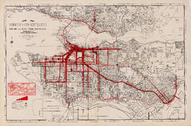
Item is a published road map of Greater Vancouver which has been annotated to show the route of a proposed circular scenic drive route through Vancouver, Burnaby, New Westminster, Coquitlam and Port Moody, as well as a proposed arterial route connecting the Pitt River Bridge to the Vancouver road network at Boundary Road.

The proposed scenic drive follows a route along Hastings Street, Stanley Park Drive, and along the entire route of Marine Drive around the University Endowment lands and east through southern Burnaby, then north from New Westminster through Coquitlam near the Alouette River.

The two pages of textual records transferred with the map itemize the specifications for paving for each section of the road.

Vancouver Park Board

Indexed guide map of the city of Vancouver and suburbs

Part is a map showing district lots, blocks, and boundaries between the City of Vancouver, Point Grey, South Vancouver, Burnaby, New Westminster, and parts of Richmond, North Vancouver and West Vancouver. Concentric circles indicate the distance in miles from the intersection of Main Street and Hastings Street in intervals of 1/2 mile.

Map of Greater Vancouver

Item is a tourist brochure enclosed within a cover. The cover contains advertising for the Hotel Grosvenor. The enclosed brochure has information on the City, on the Hotel Grosvenor and on the Douglas Lodge (Fort St. James, B.C.), another property of the same owner. The reverse of the brochure is a road map of Greater Vancouver.

Map of New Westminster District, B.C

Item is a map showing District Lots in Vancouver, and township/range designations in other areas. The map also shows False Creek Trail, North Arm Road, False Creek Road, Granville Road from Granville to Hastings, New Westminster and Burrard Inlet Road, North Road, Semiahmoo Road, New Westminster and Yale Wagon Road, and others. Annotated by W. E. Graveley, 1885, to show additional features including Kingsway, Haney, Albion Camp, etc.

Map of Vancouver, Burnaby, New Westminster, British Columbia : street index and advertisements

Part contains a street index for the main map of Vancouver on the other side of the sheet, advertisements for Bekins Moving and Storage and Allied Van Lines, and three maps showing the companies' service areas in the United States, Canada, and British Columbia and Alberta. An annotation reads: "Oppenheimer collection."

Metropolitan areas of Vancouver and Victoria, B.C. road map

Item is road map designed to be folded into a pamphlet and containing three maps showing streets in Greater Vancouver, major roads from the North Shore to Bellingham, Washington, and major roads in and around Victoria. Item also includes information about traffic rules in Vancouver and the use of the imperial gallon in British Columbia.

Results 51 to 100 of 197