
- AM427-S4-: CVA 289-265
- Item
- July 28, 1965
Part of William Orson Banfield fonds
361 results with digital objects Show results with digital objects
Part of William Orson Banfield fonds
![Second Narrows [on] harbour tour](/uploads/r/null/b/2/e/b2ea67536bdb443ce9ad21b9ce328068de0d7aa9252a7ea17ab7aeb9cec67c8f/78042a33-bebb-41f2-ac8e-edfa5de1b752-CVA289-266_142.jpg)
Second Narrows [on] harbour tour
Part of William Orson Banfield fonds

Part of William Orson Banfield fonds

Part of William Orson Banfield fonds

Part of Major Matthews collection
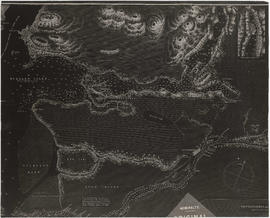
Item is a copy of a portion of a manuscript map of Burrard Inlet, created during the H.M.S. Plumper survey of the area. Sheet shows the eastern portion of the Inlet, including the southern portion of the North Arm.
United Kingdom. Admiralty

Fraser River and Burrard Inlet
Part of Major Matthews collection

Fraser River and Burrard Inlet
Part of Major Matthews collection
Fraser River and Burrard Inlet
Part of Major Matthews collection

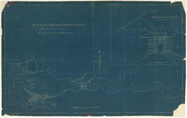
Burrard Inlet : Vancouver sheet : British Columbia
Part of City of Vancouver Archives technical and cartographic drawing collection
Item is a map showing streets, roads, buildings, trails, railways, electric railways, bridges, swing bridges, foot bridges, churches, schools, post offices, wharves, piers, dikes, piling lighthouses, lightships, beacons, ranges, range lights, buoys, triangulation stations and geographical features in Burrard Inlet from Moodyville in the east to First Narrows in the west. A small index map shows this and other numbered sheets in relation to one another.
Tidal current charts : Vancouver Harbour, British Columbia
Part of City of Vancouver Archives technical and cartographic drawing collection
Item is a booklet containing twelve charts showing tidal currents in Vancouver Harbour at different points in the tidal cycle.

North America. West Coast. Fraser River and Burrard Inlet
Part of City of Vancouver Archives technical and cartographic drawing collection
Item is a nautical chart which show details of area surveyed from Pitt Lake in the north to Roberts Bank in the south and from (what is now) Harrison Hot Springs in the east to Bowen Island in the west. The chart shows soundings in Burrard Inlet, and along the Fraser River.

Port of the City of Vancouver. Isometric view from the south-west
Part of City of Vancouver Archives technical and cartographic drawing collection
Item is a set of maps printed on one sheet. The main map shows an isometric view of the port of Vancouver from Stanley Park through the Second Narrows Bridge (including North Vancouver). The perspective point appears to be located above the Granviile Street and West Georgia Street intersection. Note that the isometric view of locations west of Granville Street is from the south-east, rather than the south-west, as indicated in the title.
The map depicts the port infrastructure, including piers, drydocks and companies located in the port.
The inset maps are a key plan showing the location of the port relative to the Lower Mainland as a whole, and a larger-scale map entitled "Plan of the Port of the City of Vancouver from Coal Harbour to Second Narrows". It contains more detail about the names of the various piers, drydocks and companies and shows the North Vancouver port facilities as well as south shore ones.

Part of Major Matthews collection
Item is a print of a map by Major James Skitt Matthews, City Archivist, showing villages, landmarks and rivers of Howe Sound and Burrard Inlet using their indigenous names. The map also shows elevations and wildlife populating the area. It was compiled between 1931 and 1937, with the assistance of August Jack Haatsalano (Khahtsahlano), whose attestation is included on the map. Notes on the map explain the map's nomenclature.
Matthews, James Skitt, Major
Fraser River and Burrard Inlet
Part of Major Matthews collection

Part of Stuart Thomson fonds
Fraser River and Burrard Inlet
Part of City of Vancouver Archives technical and cartographic drawing collection
Item is a nautical chart which show details of the area surveyed from Pitt Lake in the north to Roberts Bank in the south and from (what is now) Harrison Hot Springs in the east to Bowen Island in the west. The chart shows soundings in Burrard Inlet, and along the Fraser River.

Second Narrows Bridge, Vancouver, B.C.

A glimpse of the Narrows, Stanley Park, Vancouver, B.C.
Item is postcard printed with an image of Burrard Inlet and the First Narrows, looking north toward the North Shore from Stanley Park.

The "First Narrows" entrance to Vancouver Harbor.
Item is a postcard printed with an image of a passenger ferry entering the First Narrows. The Prospect Point lighthouse and a smaller building with a ramp leading down to the water are shown; the area of the North Shore across the First Narrows is also pictured. Postcard includes personal correspondence. Sent to Mrs. Shand in Edmonds, B.C., from F. Pullen in Vancouver.

This postcard includes personal correspondence. Sent to Miss Lotsie Lane, c.o William Peterson Esq., Saanichton P.O., Vancouver Island, B.C.

Indian Mission on Vancouver Harbor


City of Vancouver, Canadian Pacific Town Site
Part of City of Vancouver Archives technical and cartographic drawing collection
The map shows the area currently occupied by Downtown Vancouver and parts of Kitsilano. It shows the location of C.P.R. Wharf, Royal City Saw Mills, Hastings Saw Mill and Wharf, Leamy and Kyle's Saw Mill and other saw mills. "Streets graded and side-walked marked thus . . . . .." An insert shows "Canadian Pacific Mail Steamship Lines" on a map of the world. The north shore of Burrard Inlet indicates the locations of "Indian Houses" and a mission church.

First Narrows, Burrard Inlet, B.C. showing Parthia and Burnaby shoals
Part of City of Vancouver Archives technical and cartographic drawing collection
Item is a map showing shorelines, estuaries of adjacent creeks, mud flats, tide levels and soundings in feet. Map notes velocity of current at First Narrows.
New Westminster (B.C.). Department of Public Works

Part of City of Vancouver Archives technical and cartographic drawing collection
Item is an architectural drawing of a Second Narrows crossing, bridging Vancouver and North Vancouver. The drawing consists of an elevation of the bridge, as well as a plan of the bridge and the north and south approaches.
Suggested harbour improvements Burrard Inlet
Part of City of Vancouver fonds

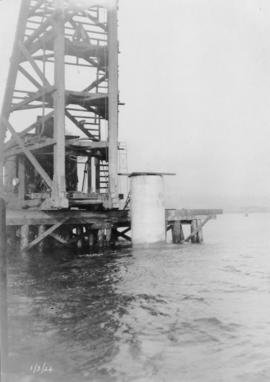
Pier and pile driver : March 1, 1924
Item is a photograph related to the building of the Second Narrows Bridge.
Close-up of pier and pile driver : March 1, 1924
Item is a photograph related to the building of the Second Narrows Bridge.

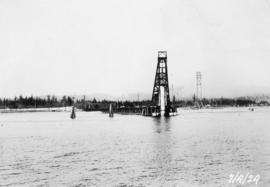
Pier and pile driver : March 1, 1924
Item is a photograph related to the building of the Second Narrows Bridge.
Close-up of pile driver putting in pier : April 7, 1924
Item is a photograph related to the building of the Second Narrows Bridge.
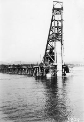
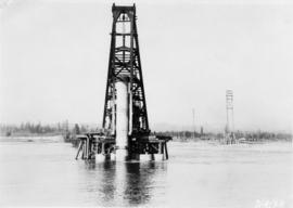
Pile driver putting in a pier : April 7, 1924
Item is a photograph related to the building of the Second Narrows Bridge.

Dock with docked offices, pile driver, and crane : April 7, 1924
Item is a photograph related to the building of the Second Narrows Bridge.

Pile driver putting in a pier : April 7, 1924
Item is a photograph related to the building of the Second Narrows Bridge.

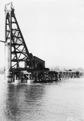
View of timber trestle and pile driver putting in a pier : April 7, 1924
Item is a photograph related to the building of the Second Narrows Bridge.

Close-up of pile driver : April 7, 1924
Item is a photograph related to the building of the Second Narrows Bridge.

Pile driver inserting a piling : April 7, 1924
Item is a photograph related to the building of the Second Narrows Bridge.
Pile driver putting in a pier and view of timber trestle : April 7, 1924
Item is a photograph related to the building of the Second Narrows Bridge.
Pile driver putting in a pier : April 7, 1924
Item is a photograph related to the building of the Second Narrows Bridge.

View of timber trestle : April 7, 1924
Item is a photograph related to the building of the Second Narrows Bridge.

Placing struts at pier 1 : April 19, 1924
Item is a photograph related to the building of the Second Narrows Bridge.

Close-up of builders placing struts at pier 1 : April 19, 1924
Item is a photograph related to the building of the Second Narrows Bridge.

Item is a photograph related to the building of the Second Narrows Bridge.

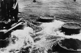
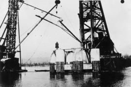
Close-up of caisson 5 : April 19, 1924
Item is a photograph related to the building of the Second Narrows Bridge.
Pier 1 before placing struts : April 22, 1924
Item is a photograph related to the building of the Second Narrows Bridge.
Placing struts at pier 1 : April 30, 1924
Item is a photograph related to the building of the Second Narrows Bridge.
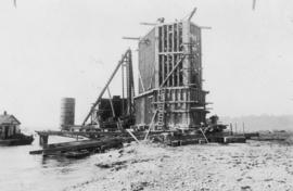
Caisson for pier 4 : April 30, 1924
Item is a photograph related to the building of the Second Narrows Bridge.

Placing struts at pier 1 : April 30, 1924
Item is a photograph related to the building of the Second Narrows Bridge.

Item is a photograph related to the building of the Second Narrows Bridge.

Building caisson 3 : May 5, 1924
Item is a photograph related to the building of the Second Narrows Bridge.