Bill 55 : an act to incorporate Vancouver Terminal Railway Company
- AM1519-: PAM 1915-4
- Item
- 1915
604 results with digital objects Show results with digital objects
Bill 55 : an act to incorporate Vancouver Terminal Railway Company
Bill of an act to incorporate Grouse Mountain Scenic Railway Company
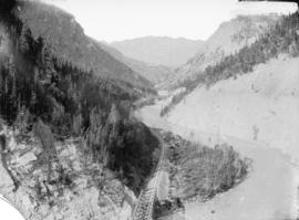
Bird's eye view Lower Kicking Horse Canyon
Part of Major Matthews collection
Photograph shws bridge, railway tracks and river through canyon.

Bitter Root Mountains on Milwaukee R.R.
Part of William Orson Banfield fonds

"Black Bird Trestle", North Shore Lake Superior
Part of Major Matthews collection

Blackbird trestle, C.P.R. North Shore Lake Superior
Part of Major Matthews collection
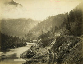
Bluffs, 2 1/2 miles above Yale looking down valley
![[Board of Trade trip - The Skeena bridge, Terrace, B.C.]](/uploads/r/null/8/0/8015c358f62543027885ab25181cdd8903a42cca0ca4e4d65e64602b53d7aa30/45d79e4f-87b4-4a2f-97b1-da909a1455a8-CVA1477-741_142.jpg)
[Board of Trade trip - The Skeena bridge, Terrace, B.C.]
Part of L.D. Taylor family fonds
Inscription by L.D. Taylor on the verso reads: "Bridge at Terrace, B.C. opened - Board of Trade."
![[Boats decorated for visit of King George VI and Queen Elizabeth]](/uploads/r/null/3/3/33d57a5bfaa8c634466fa400c3ecaf283ea6719331e153546e53e6d5677c77de/08ae4778-89a6-4f7b-89ab-b9de2b7b0c28-A19996_142.jpg)
[Boats decorated for visit of King George VI and Queen Elizabeth]
Part of Vancouver Committee for the Reception of their Majesties fonds

Part of Major Matthews collection
Photograph shows buildings and railway lines.

Bridge near North Bend, C.P.R.
Part of Elizabeth Abbott fonds
British Columbia Electric Railway Limited : twenty-nine years of public service
British Columbia Electric Railway N.E.L.A. Convention

Part of City of Vancouver Archives technical and cartographic drawing collection
Item is a map showing railway lines from Kamloops to the Vancouver, homesteads, lands disposed of by the provincial government, Indian reserves, forest reserves and parks, timber berths, grazing leases and land sales, land grants and mining land sales. Inset shows Vancouver Island and its railway line.
![[Buildings west of the Marine Building]](/uploads/r/null/4/3/4390c59cbc16a7d4cb9d2c9bbd18f9cf8aec320e5b3a15b43f20f2c76300d45f/f55ebf41-49e3-4ad3-a051-988f0034b6a4-A08803_142.jpg)
[Buildings west of the Marine Building]
Part of Major Matthews collection
Photograph shows buildings near railway tracks behind the Marine Building, including the Quadra Club, a bunkhouse from Spratt's Oilery, and the Blue Ribbon Tea and Coffee building. Photograph also shows trees and bushes in a vacant lot, and an entrance to a C.P.R. tunnel. J.S. Matthews' notes with print or negative in Archives.
![[Buntzen Lake Dam under construction]](/uploads/r/null/8/9/89e05851fc9849500789e66325ccbb0dab13cebec4618829b8683b45363b0e5e/16b1c6e9-1b1d-4efe-9699-11f9b4398b52-A23315_142.jpg)
[Buntzen Lake Dam under construction]
Part of Major Matthews collection
Canadian Forest Products Limited Nimpkish Valley Railway
![[Canadian Forest Products railcar on a barge in False Creek]](/uploads/r/null/a/c/accad4424b3534c5a06f3ead5d9b6ff2815c874dff223a09fe0967a7125f609d/ee1d7ee1-57e0-4ba0-8546-3fe6844beb06-A13462_142.jpg)
[Canadian Forest Products railcar on a barge in False Creek]
Photograph shows the barge with the Burrard Street Bridge and Kitsilano Trestle in the background.
Canadian National Railway presentation at Superintendent's Office
Canadian National Railways magazine
Canadian National Railways mountain region : Vancouver, B.C.
Part of City of Vancouver Archives technical and cartographic drawing collection
Item is a map showing major roads, highways, railways and industrial centres in the Lower Mainland (from Langley west). The map shows nine different railway lines and the Roberts Bank development, with land described based on four categories: First stage - causeway plus 50 acres; Federal government - ultimate development; Provincial government - reclaimed industrial land; and Provincial government - assembled land.
Canadian Pacific : staff bulletin
Canadian Pacific : staff bulletin
Canadian Pacific Empress mail : Tuesday
![[Canadian Pacific rail line along the Fraser River]](/uploads/r/null/f/5/f5068a6b7c226036874b05895a1ce07e51790a03e2d69a53f27e91e33c04121d/ce9b2c39-5dcc-4d47-ada8-79bc292af478-A03866_142.jpg)
[Canadian Pacific rail line along the Fraser River]
Location may be near Hammond, B.C.
Canadian Pacific Railway company R.M.S. "Empress of Japan" breakfast menu
Canadian Pacific Railway Company R.M.S. "Empress of Japan" menu
Canadian Pacific Railway construction : employment of Chinese : Andrew Onderdonk [contractor]
Part of H.A. Price collection
Item is a sectional map showing the Eburne [Marpole] tyo New Westminster branch line of the Vancouver and Lulu Island Railway. The map also shows District Lot lot numbers and names associated with properties adjacent to the line.
Canadian Pacific Railway Company. Engineering Office

Item is a map showing land subdivision in downtown Vancouver around Burrard Inlet, and the route of the Canadian pacific Railway along the south shore of Burrard Inlet.
![[Canadian Pacific Railway train crossing at Carrall Street]](/uploads/r/null/c/e/ceb9436e35e7b3b380a69ac2c569efa1afebc415767f71e701fef5ec7e1335e7/fea9b087-56f2-4a1b-804a-610d381ee009-A09126_142.jpg)
[Canadian Pacific Railway train crossing at Carrall Street]
Part of Major Matthews collection
Photograph shows tracks being removed after use of crossing discontinued. J.S. Matthews' notes with print or negative in Archives.
![[Canadian Pacific Railway train crossing Hastings Street]](/uploads/r/null/6/a/6a0c6e8250256deb67ad8d5e3e7be768662201bc5e7af47f5b4c303254594f6d/a6dedf95-3dd0-4d55-94cb-c49f3dc64f47-A09127_142.jpg)
[Canadian Pacific Railway train crossing Hastings Street]
Part of Major Matthews collection
J.S. Matthews' notes with print or negative in Archives.
Canadian rail: no. 363, April 1982
Canadian Railroad Historical Association
Canadian Railroad Historical Association : a selected bibliography on railways in BC : part I
Canadian Railroad Historical Association : statistics for the BC railway historian
Canyon Creek Trestle, 165 feet high
Part of William Orson Banfield fonds

Canyon, Illecillewaet River, C.P.R.
Part of Elizabeth Abbott fonds
![[Capilano Creek waterworks]](/uploads/r/null/7/7/77575f1809735b16a9944f412163f98f596dd55ac925f50b13267002dfa3ffb8/232096c5-a1aa-4f89-8724-7825d09e71e0-A25800_142.jpg)
Part of Major Matthews collection

Part of Major Matthews collection
Catalogue of views along the line of the Canadian Pacific Railway and British Columbia
Chancellor Day : adjournment Wednesday, Aug. 22, 1888 C.P.R. versus the Queen

Part of City of Vancouver Archives technical and cartographic drawing collection
Map is a topographical plan showing the proposed hydroelectric development on the Cheakamus River near Mile 19, Pacific Great Eastern Railway. Indicated on the map are the locations of tunnels, dams, by-passes, pipelines, the railway line, and the power station for the Cheakamus Canyon development. The map was created to accompany E.A. Cleveland's "Report on a Preliminary Investigation of the Cheakamus River Power Possibilities made for the City of Vancouver." Map has been numbered Tube 59.

Part of City of Vancouver Archives technical and cartographic drawing collection
Map is a topographical plan showing the proposed diversion works on the Cheakamus River near Mile 19, Pacific Great Eastern Railway. Indicated on the map are the locations of tunnels, dams and the railway line. The map was created to accompany E.A. Cleveland's "Report on a Preliminary Investigation of the Cheakamus River Power Possibilities made for the City of Vancouver." Map is numbered Tube 60.