Project 2, part of area "a" : plan of redevelopment
- COV-S648-F0686-: MAP 987
- Item
- May 1963
Part of City of Vancouver fonds
Item is a map showing the boundaries of clearance areas for projects 1 and 2, the proposed land use (residential, commercial, industrial or school and park sites), the proposed ultimate street system, the new streets and lanes in projects 1 and 2, the easements in projects 1 and 2, the sites in project 2 not to be acquired and the buildings in projects 1 and 2 to be retained.


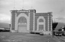
![50 Dunlevy Avenue [revised address 401 E.Waterfront Rd]](/uploads/r/null/d/9/7/d9712d2cf3afb1e65eef6faf19ada6a6502e0f81ec996353b184812cb9e93ff7/c562f07c-3d4d-4a98-8c54-0c0ab1cd78b2-CVA791-1239_142.jpg)
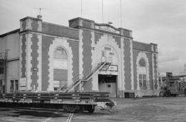
![50 Dunlevy Avenue [revised address 401 E.Waterfront Rd]](/uploads/r/null/b/8/4/b84bfda8379460a9c32d54fb7564b78847ef743be34d05f09e651ab7db4841bd/295869a9-d38a-423f-b792-59c1fb8d485c-CVA791-1240_142.jpg)
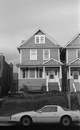
![50 Dunlevy Avenue [revised address 401 E.Waterfront Rd]](/uploads/r/null/2/2/7/22741681b5f01276d5313dd7ed053c7aabc2abf57a394603ed731e2c9fe7c3d8/c131e0d9-9c60-496c-9bc8-ad2d0d0efb97-CVA791-1241_142.jpg)
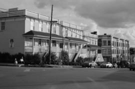
![50 Dunlevy Avenue [revised address 401 E.Waterfront Rd]](/uploads/r/null/9/2/c/92c99418069c2bbb9dd2ec300cfe2fd45645eaf4042f897c71adf2099ad30cfe/121149fb-93b3-4e11-a37f-f203424ff0fa-CVA791-1242_142.jpg)
![50 Dunlevy Avenue [revised address 401 E.Waterfront Rd]](/uploads/r/null/8/c/1/8c1f10165152c5ce416c6088a9f6e3dc5809e1db315dd081c979e5da8d9e7511/d7141dad-1126-455f-9bdd-8a1ec3628540-CVA791-1243_142.jpg)
![50 Dunlevy Avenue [revised address 401 E.Waterfront Rd]](/uploads/r/null/9/3/2/932f5dc989cf9fc946a2e965e6976ae2be59c2003e89b105e954683cf1175c6f/50fda098-514d-4bf7-bc9d-01fe100b7b33-CVA791-1244_142.jpg)