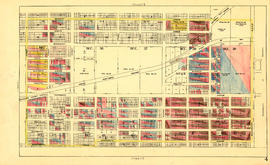
Sheet 17 : Argyle Street to Vivian Street and Sixty-second Avenue to Kent Street
- COV-S303-MAP 343-: MAP 343.63
- Item
- [ca. 1925], with revisions to [ca. 1945]
Part of City of Vancouver fonds
Item is a section showing the area from Argyle Street to Vivian Street and Sixty-second Avenue to Kent Street. Includes streets, roads, blocks, lots, legal descriptions and golf courses. Map is hand coloured to show tax sale property for sale, property with no water, street widening and drainage, replotting, reserved land for schools, reserved land for parks, sundry land, capital assets not including schools and parks, schools, and parks, as applicable. "22, 23, 25 to 33, 35, 36/258-329" is written in ink at the top of the map.
Vancouver (B.C.). Office of the City Engineer