
- COV-S60-2-: 2013-014.18
- Item
- 1996
Part of City of Vancouver fonds
Part of City of Vancouver fonds

Part of City of Vancouver fonds

Part of City of Vancouver fonds

Part of City of Vancouver fonds

Part of City of Vancouver fonds
Part of City of Vancouver fonds
![Granville Bridge [sound version]](/uploads/r/null/3/4/340ca9d42b1aff5f7583c01d64cc460bed732705bc0550fbea173e5e277b9fdf/0390ec37-8b58-4ebc-9732-145cdc20def0-2013-020_142.jpg)
Granville Bridge [sound version]
Part of City of Vancouver fonds
Item consists of a motion picture film developed for the Engineering Department of the City of Vancouver detailing the construction of the new Granville Street Bridge over False Creek. The film makes use of stock footage, original footage, and a voice over narration to tell the story of the problems the new bridge was built to solve, and how it solved them.
The film begins with a discussion of downtown traffic congestion and includes street scenes, the Woodward's building, and the Marine Building, and dramatized depictions of impatient people in cars and stock footage of the old swing span in action. Staged shots of engineers and bridge models are used to support a discussion of the planning process before construction. The film includes footage of the ground-breaking ceremony with Mayor Frederick Hume and members of council, demolition of buildings to make room for the bridge and ramps, sinking foundation piles, foundation pouring for the main bridge piers.
The film discusses the advantages the new bridge would bring to the city, with scenes of families playing in Stanley Park, at the zoo, on a miniature train, and at the beaches. More construction details are included: piers are sunk into False Creek and pre-fabricated steel beams, are moved into place. The narration discusses the pneumatic rivet delivery system developed for the bridge; the remained of construction to completion is depicted. The film includes the opening ceremony, attended by Mayor Hume and councillors, and the completed bridge is shown from several angles.
Lew Parry Film Productions
![3380 Granville Street - People's Republic of China [consulate]](/uploads/r/null/0/8/a/08a89323b51c34ebbc8781cb6cc0844bc85055321e0ada09fc4bd7aa984a5584/20c8a161-6ec4-4150-b555-6233d0417552-2014-022_142.jpg)
3380 Granville Street - People's Republic of China [consulate]
Part of City of Vancouver fonds

SW corner Granville & Angus - rooming house
Part of City of Vancouver fonds

Part of City of Vancouver fonds

Part of City of Vancouver fonds

Part of City of Vancouver fonds
![People's Republic of China [consulate] - potential for subdivision](/uploads/r/null/2/e/a/2ea5014bb9945b53358cda0a20defb360a94f1f1b3bd504c93da3b58a6ff8599/6dbf7f81-875e-45a3-ad97-ab299a3a067c-2014-022_142.jpg)
People's Republic of China [consulate] - potential for subdivision
Part of City of Vancouver fonds

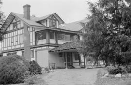
3590 Hudson Street - Clarence House
Part of City of Vancouver fonds

3596 Hudson Street - vacant for several years - one of "five dragons?"
Part of City of Vancouver fonds
3637 Hudson Street - lot proposed for subdivision adjacent to former monastery
Part of City of Vancouver fonds

3690 Hudson Street - contemporary home - consider for design suitability
Part of City of Vancouver fonds

3707 Hudson Street - new home resulting from subdivision of H.R. McMillan property
Part of City of Vancouver fonds

SE corner of Hudson & Laurier - unsympathetic fence
Part of City of Vancouver fonds

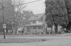
1250 Laurier Street - new construction out of character with surrounding development
Part of City of Vancouver fonds

Part of City of Vancouver fonds

Part of City of Vancouver fonds

Part of City of Vancouver fonds

Looking east on Laurier from Osler
Part of City of Vancouver fonds
3603 Osler - renovations to a rooming house
Part of City of Vancouver fonds

3590 Osler - implications of lack of control through RS-4 by-law
Part of City of Vancouver fonds
Looking north-east at Osler and Matthews
Part of City of Vancouver fonds

Part of City of Vancouver fonds

Part of City of Vancouver fonds
![Unidentified Shaughnessy house [McRae & 16th Avenue?]](/uploads/r/null/e/9/e/e9eebcd5ebae3dcecdb4f3bbfc6e769af483ab94c001643673e56a580e5dac47/72e31134-0de3-48db-b1ea-1b2b1937f2c2-2014-022_142.jpg)
Unidentified Shaughnessy house [McRae & 16th Avenue?]
Part of City of Vancouver fonds
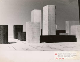
Taken from Chilco and Nelson streets looking towards English Bay
Part of City of Vancouver fonds
Item consists of a photograph depicting a model created by Planning Department staff to study view obstructions which result from various building configurations, based on different options to be included in zoning regulations for the West End.
Vancouver (B.C.). Planning Department

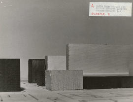
Taken from Comox and Bidwell streets looking towards English Bay
Part of City of Vancouver fonds
Item consists of a photograph depicting a model created by Planning Department staff to study view obstructions which result from various building configurations, based on different options to be included in zoning regulations for the West End.
Vancouver (B.C.). Planning Department
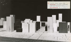
Taken from Comox and Nicola streets looking towards English Bay
Part of City of Vancouver fonds
Item consists of a photograph depicting a model created by Planning Department staff to study view obstructions which result from various building configurations, based on different options to be included in zoning regulations for the West End.
Vancouver (B.C.). Planning Department

Taken from Pendrell and Broughton streets looking towards English Bay
Part of City of Vancouver fonds
Item consists of a photograph depicting a model created by Planning Department staff to study view obstructions which result from various building configurations, based on different options to be included in zoning regulations for the West End.
Vancouver (B.C.). Planning Department

Part of City of Vancouver fonds
Item is a film showing a boy [Arnold Stride] talking to Fire Chief R.R. Jacks and witnessing two rescue drills.

Part of City of Vancouver fonds

Part of City of Vancouver fonds

Part of City of Vancouver fonds

Part of City of Vancouver fonds

Part of City of Vancouver fonds
Item is a photograph showing a City plaque for the False Creek Shoreline project.

Part of City of Vancouver fonds
Item is a photograph showing a new path and cleared area for the seawall. Buildings are visible in the background including the Sigurdson Millwork Co. located at 1275 West 6th.

Part of City of Vancouver fonds
Item is a photograph showing the marina looking northwest with the Burrard Bridge in the background.

Part of City of Vancouver fonds
Item is a photograph showing the seawall under construction.

Part of City of Vancouver fonds
Item is a photograph showing the seawall under construction.

Part of City of Vancouver fonds
Item is a photograph showing the seawall under construction.

Part of City of Vancouver fonds
Item is a photograph showing the seawall under construction.