
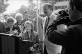
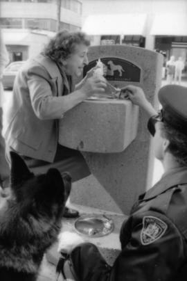
Mike Harcourt and Theresa Galloway at drinking fountain inauguration
- COV-S477-3-F111-: CVA 775-189-: CVA 775-189.19
- Part
- Oct. 1, 1986
Part of City of Vancouver fonds
379 results with digital objects Show results with digital objects
Mike Harcourt and Theresa Galloway at drinking fountain inauguration
Part of City of Vancouver fonds
Theresa Galloway and Mike Harcourt at drinking fountain inauguration
Part of City of Vancouver fonds
Mike Harcourt and Theresa Galloway at drinking fountain inauguration
Part of City of Vancouver fonds

Mike Harcourt and Theresa Galloway at drinking fountain inauguration
Part of City of Vancouver fonds
Mike Harcourt and Theresa Galloway at drinking fountain inauguration
Part of City of Vancouver fonds
Mike Harcourt and Theresa Galloway at drinking fountain inauguration
Part of City of Vancouver fonds

Theresa Galloway drinking from fountain
Part of City of Vancouver fonds
Theresa Galloway drinking from fountain
Part of City of Vancouver fonds

Theresa Galloway and group of women pose with drinking fountain
Part of City of Vancouver fonds

Theresa Galloway and group of women pose with drinking fountain
Part of City of Vancouver fonds

Part of City of Vancouver fonds

Part of City of Vancouver fonds
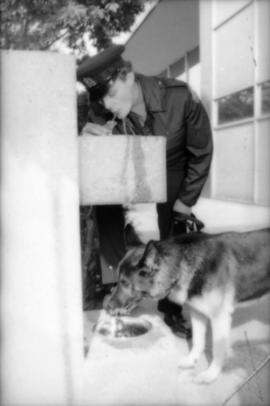
Constable Rob Bosley and police dog Sport at drinking fountain
Part of City of Vancouver fonds

Constable Rob Bosley and police dog Sport at drinking fountain
Part of City of Vancouver fonds

Constable Rob Bosley and police dog Sport at drinking fountain
Part of City of Vancouver fonds
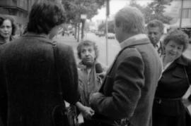
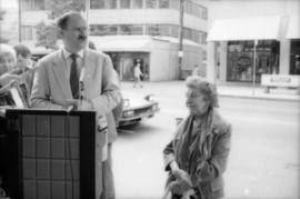
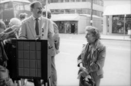
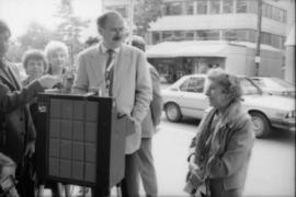
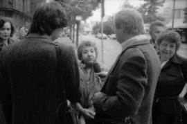
Theresa Galloway speaking to press at drinking fountain inauguration
Part of City of Vancouver fonds
Theresa Galloway speaking to press at drinking fountain inauguration
Part of City of Vancouver fonds

Theresa Galloway and police dog Sport at drinking fountain inauguration
Part of City of Vancouver fonds

Theresa Galloway and police dog Sport at drinking fountain inauguration
Part of City of Vancouver fonds
Part of City of Vancouver fonds
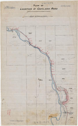
Part is the northern half of a map of the Capilano River, depicting the area of the Capilano River valley from District Lots 595 and 602 north to the dam located in District Lot 673.

Part of City of Vancouver fonds
Part is the southern half of a map of the Capilano River, depciting the area of the Capilano River valley from the river's mouth at Burrard Inlet north to District Lot 596.
![Sheet No. 1 [Ontario Street to 16th Avenue to Cambie Street to 23rd Avenue]](/uploads/r/null/4/d/d/4dd3d21cd72c689cdfec84f31637e9a1c0960c1d2d6d15e3441fafba4e5c91ee/8198c61c-ff71-45ed-b5c5-3e2c8c212922-LEG1153_142.jpg)
Sheet No. 1 [Ontario Street to 16th Avenue to Cambie Street to 23rd Avenue]
Part of City of Vancouver fonds
![Sheet No. 2 [Ontario Street to 23rd Avenue to Cambie Street to Mountain Drive]](/uploads/r/null/2/e/1/2e16747fa711f92cb8188e84813f1fe48ca93469dbe022432043b9233f7ee8f2/ca92ea85-917d-4bce-85d2-374cc3801699-LEG1153_142.jpg)
Sheet No. 2 [Ontario Street to 23rd Avenue to Cambie Street to Mountain Drive]
Part of City of Vancouver fonds
![Sheet No. 3 [Little Mountain south to Thirty-seventy Avenue]](/uploads/r/null/8/0/7/80763848604372ba093e892df667bdddf5e9d21d755078b87e7ba0adceaeac38/c55f1a1e-c5ea-4a50-9e59-35902c1092e4-LEG1153_142.jpg)
Sheet No. 3 [Little Mountain south to Thirty-seventy Avenue]
Part of City of Vancouver fonds
![Sheet No. 4 [Ontario Street to Thirty-eighth Avenue to Cambie Street to Forty-fifth Avenue]](/uploads/r/null/b/8/c/b8c7af16df3c770f11c0a155c3ba9134ca5f19e367c575723031f91befaa91d7/e1447111-79bb-45a0-98f4-fa349ed27d09-LEG1153_142.jpg)
Sheet No. 4 [Ontario Street to Thirty-eighth Avenue to Cambie Street to Forty-fifth Avenue]
Part of City of Vancouver fonds
![Sheet No. 5 [Ontario Street to Forty-fifth Avenue to Cambie Street to Forty-ninth Avenue]](/uploads/r/null/1/f/1/1f17e485ff8505c9ad9b4316c404cfff72e76d3f9918a678f98247b5281f765e/dd6f5950-270a-4467-b83f-26a0bc4752f4-LEG1153_142.jpg)
Sheet No. 5 [Ontario Street to Forty-fifth Avenue to Cambie Street to Forty-ninth Avenue]
Part of City of Vancouver fonds
![Sheet No. 6 [Ontario Street to Fifty-ninth Avenue to Ash Street to SW Marine Drive]](/uploads/r/null/6/3/0/6307241d025a7bdcfa15c0fbc20a7e50a0e5c0574df2c760028188c3ffaccd3f/781e01dc-197b-4c60-8c1f-0ed145e92003-LEG1153_142.jpg)
Sheet No. 6 [Ontario Street to Fifty-ninth Avenue to Ash Street to SW Marine Drive]
Part of City of Vancouver fonds
![Sheet No. 7 [Main Street to Sixteenth Avenue to Ontario Street to Twenty-third Avenue]](/uploads/r/null/7/8/f/78f5936553469a42d02b6d7d884c0ccface8e869efb00ea32ea24de3add7c302/86390abc-e710-4642-b04a-85890b9ce574-LEG1153_142.jpg)
Sheet No. 7 [Main Street to Sixteenth Avenue to Ontario Street to Twenty-third Avenue]
Part of City of Vancouver fonds
![Sheet No. 8 [George Street to King Edward Avenue to Ontario Street to Thirtieth Avenue]](/uploads/r/null/f/0/7/f077d1dfb6f6da927e00bd6cd4e3944aba3ea7a93b1c2076a280a8e003fb7b59/c0c04996-4ae8-4163-bab7-7398e0b0942a-LEG1153_142.jpg)
Sheet No. 8 [George Street to King Edward Avenue to Ontario Street to Thirtieth Avenue]
Part of City of Vancouver fonds
![Sheet No. 9 [George Street to Thirtieth Avenue to Ontario Street to Thirty-eighth Avenue]](/uploads/r/null/c/8/c/c8c223273de73dd975de4d45feac09eec2dcfde8226aaa0e1b8f1426493a4389/bc29ee5f-42d7-4859-990c-c55084703959-LEG1153_142.jpg)
Sheet No. 9 [George Street to Thirtieth Avenue to Ontario Street to Thirty-eighth Avenue]
Part of City of Vancouver fonds
![Sheet No. 10 [George Street to Thirty-eighth Avenue to Ontario Street to Forty-fifth Avenue]](/uploads/r/null/c/7/b/c7b4c32e4e766f9f7bbb885b57274132350e9acb7f1ca1595e42ccb2424079e6/b422e91a-0aba-46ea-9c43-9684ffe01f17-LEG1153_142.jpg)
Sheet No. 10 [George Street to Thirty-eighth Avenue to Ontario Street to Forty-fifth Avenue]
Part of City of Vancouver fonds
![Sheet No. 11 [George Street to Forty-fifth Avenue to Ontario Street to Fifty-third Avenue]](/uploads/r/null/4/3/4/4348da4644ccf7761bc0f6db3c87ef18f9bfd8d90450e978e0e726b0d9484a04/17c15ecb-824c-4022-be56-e84aa0be7ea1-LEG1153_142.jpg)
Sheet No. 11 [George Street to Forty-fifth Avenue to Ontario Street to Fifty-third Avenue]
Part of City of Vancouver fonds
![Sheet No. 12 [George Street to Fifty-third Avenue to Ontario Street to Sixty-first Avenue]](/uploads/r/null/8/f/9/8f9e77c2cd40cd382f0e142f786d72bec4064d057d60c891dcf38c3b16789b5d/ad81361d-2edc-4274-ae6a-ad25c0974c51-LEG1153_142.jpg)
Sheet No. 12 [George Street to Fifty-third Avenue to Ontario Street to Sixty-first Avenue]
Part of City of Vancouver fonds
![Sheet No. 13 [George Street to Sixty-first Avenue to Ontario Street to SE Marine Drive]](/uploads/r/null/0/1/5/015bcd2538ace9b87e5e73b14a4ddbe9ef2ef537b5735cd5ac70d80ec3d39df9/1f0f85ae-f31c-4296-aa5d-8819050f5abe-LEG1153_142.jpg)
Sheet No. 13 [George Street to Sixty-first Avenue to Ontario Street to SE Marine Drive]
Part of City of Vancouver fonds
![Sheet No. 14 [George Street to SE Marine Drive to ca. Ontario Street to Fraser River]](/uploads/r/null/4/c/9/4c9e9493bcd9b76372614fb297eae315d0f4c5d4a28e352899842d065aec31bb/3cd5e63d-1b47-4e15-b0ae-d72ace82d5a6-LEG1153_142.jpg)
Sheet No. 14 [George Street to SE Marine Drive to ca. Ontario Street to Fraser River]
Part of City of Vancouver fonds
![Sheet No. 15 [Elgin Street to King Edward Avenue to George Street to Thirty-first Avenue]](/uploads/r/null/2/a/c/2ac6f05835172a9ea560b349ff63f7c51819b8a95c478b877e491092079a75d7/3c088f2b-3816-43a2-b820-8410bb3978ca-LEG1153_142.jpg)
Sheet No. 15 [Elgin Street to King Edward Avenue to George Street to Thirty-first Avenue]
Part of City of Vancouver fonds
![Sheet No. 16 [Elgin Street to Thirty-first Avenue to George Street to Thirty-seventh Avenue]](/uploads/r/null/6/9/5/695feca13c8efdfb42f0117089b336c5b716f9b46f34fd230b843586dc652633/b5bcc336-2de9-4410-9909-73df03c3ce64-LEG1153_142.jpg)
Sheet No. 16 [Elgin Street to Thirty-first Avenue to George Street to Thirty-seventh Avenue]
Part of City of Vancouver fonds
![Sheet No. 17 [Ross Street to Thirty-seventh Avenue to George Street to Forty-fifth Avenue]](/uploads/r/null/9/a/8/9a86378b20bae8e5ff7a19553904ecd0f0215f5011760aed5fd6800b4cb1229b/aef15833-fcfc-4f39-9147-8837c68fcf81-LEG1153_142.jpg)
Sheet No. 17 [Ross Street to Thirty-seventh Avenue to George Street to Forty-fifth Avenue]
Part of City of Vancouver fonds
![Sheet No. 18 [Ross Street to Forty-fifth Avenue to George Street to Fifty-third Avenue]](/uploads/r/null/c/d/5/cd53e0b360baa096e964461fbf48f14020d2b297d61c7624b392cfa07ac21127/829a9c0c-93c0-42d2-ad73-f58642c2e8f1-LEG1153_142.jpg)
Sheet No. 18 [Ross Street to Forty-fifth Avenue to George Street to Fifty-third Avenue]
Part of City of Vancouver fonds
![Sheet No. 19 [Ross Street to Fifty-third Avenue to George Street to Sixty-second Avenue]](/uploads/r/null/c/3/8/c385ca273e667891003aaebaeec57247246dea0a46a9291041aa776a34431dfc/c3c5ce89-d21e-4123-a175-71705dcf8aaa-LEG1153_142.jpg)
Sheet No. 19 [Ross Street to Fifty-third Avenue to George Street to Sixty-second Avenue]
Part of City of Vancouver fonds
![Sheet No. 20 [Ross Street to Sixty-second Avenue to George Street to Fraser River]](/uploads/r/null/5/1/2/512cd35dd560dd6a2b3fc3ac13b73c7b1ec8c17888d2c5cd86b2c403dabf3b2b/d0c300a4-8a25-47c9-9c7e-ccb30e365174-LEG1153_142.jpg)
Sheet No. 20 [Ross Street to Sixty-second Avenue to George Street to Fraser River]
Part of City of Vancouver fonds
![Sheet No. 21 [Knight Street to King Edward Avenue to Elgin Street to Thirty-third Avenue]](/uploads/r/null/5/6/f/56f59eada683d2d8ec669a63699443c4286d9e30fa8776005f872cbbef5c0481/e95d90c6-91c4-45fc-8cba-b87032659e22-LEG1153_142.jpg)
Sheet No. 21 [Knight Street to King Edward Avenue to Elgin Street to Thirty-third Avenue]
Part of City of Vancouver fonds
![Sheet No. 22 [Argyle Street to 31st/Thirty-third Avenue to Elgin Street to Thirty-seventh Avenue]](/uploads/r/null/b/0/1/b019540bcf26bbf9ee1a2b7a8d48de80077cb8c44ea6fc7991b40c042b32ae51/e982e5f0-1eb5-42ff-aa8a-00573fcb171e-LEG1153_142.jpg)
Sheet No. 22 [Argyle Street to 31st/Thirty-third Avenue to Elgin Street to Thirty-seventh Avenue]
Part of City of Vancouver fonds
![Sheet No. 23 [Argyle Street to Thirty-seventh Avenue to Ross Street to Forty-fifth Avenue]](/uploads/r/null/4/3/e/43e5f94bb5e159f8bf7b9e4058c7c8b1ef6f55f02ca2c1000747f1d987c8d8fe/a062912e-c409-4433-86ce-dc0b286d06e7-LEG1153_142.jpg)
Sheet No. 23 [Argyle Street to Thirty-seventh Avenue to Ross Street to Forty-fifth Avenue]
Part of City of Vancouver fonds
![Sheet No. 24 [Argyle Street to Forty-fifth Avenue to Ross Street to Fifty-third Avenue]](/uploads/r/null/4/2/3/4234b0fc05be0a1c8439cd4c1f31e6037a68ada5bb2c7301c16108831b897ad9/2465a3e3-da31-4f96-91de-8617e753e844-LEG1153_142.jpg)
Sheet No. 24 [Argyle Street to Forty-fifth Avenue to Ross Street to Fifty-third Avenue]
Part of City of Vancouver fonds
![Sheet No. 25 [Argyle Street to Fifty-third Avenue to Ross Street to Sixty-first Avenue]](/uploads/r/null/6/5/0/65079e93d7b8bfcd4f3d1604d96852cef0622e47dcdf127a13b4c1ba2768d35d/6f645e45-6989-4173-a77e-db173af5ea15-LEG1153_142.jpg)
Sheet No. 25 [Argyle Street to Fifty-third Avenue to Ross Street to Sixty-first Avenue]
Part of City of Vancouver fonds
![Sheet No. 26 [Argyle Street to Sixty-first Avenue to Ross Street to Fraser River]](/uploads/r/null/d/8/5/d85899ed4866e6864ca8c8685292167d48ba2555e0908db68dc75c7b8647c258/2f5594d4-3328-447e-80b4-00d6c79954d5-LEG1153_142.jpg)
Sheet No. 26 [Argyle Street to Sixty-first Avenue to Ross Street to Fraser River]
Part of City of Vancouver fonds
![Sheet No. 27 [Victoria Drive to Fifteenth Avenue to Knight Street to Twenty-second Avenue]](/uploads/r/null/4/7/f/47f6d3060e6a52bd251a12090de447894b096c07ce6a5d2131a8a5bd6fd12968/f8a0dd0d-2691-4c7b-82e0-bab193380a27-LEG1153_142.jpg)
Sheet No. 27 [Victoria Drive to Fifteenth Avenue to Knight Street to Twenty-second Avenue]
Part of City of Vancouver fonds
![Sheet No. 28 [Victoria Drive to Twenty-second Avenue to Knight Street to Thirty-first Avenue]](/uploads/r/null/0/9/1/09173e21fa4080b1ed8efbcb4d2ca44494e94902c203c138ccf5e85e51f39aa8/617d15f4-5e8d-41cc-b7ff-555b4ea61337-LEG1153_142.jpg)
Sheet No. 28 [Victoria Drive to Twenty-second Avenue to Knight Street to Thirty-first Avenue]
Part of City of Vancouver fonds
![Sheet No. 29 [Nanaimo Street to Thirty-fourth/31st Avenue to Argyle Street to Thirty-eighth Avenue]](/uploads/r/null/6/b/b/6bbc93f2896876c45ae4cf50563502c9649b43167ceb9b4b38ebefcba979e562/718873b2-7d20-435d-b887-48915a235875-LEG1153_142.jpg)
Sheet No. 29 [Nanaimo Street to Thirty-fourth/31st Avenue to Argyle Street to Thirty-eighth Avenue]
Part of City of Vancouver fonds