
A student to-day, a citizen tomorrow
- AM1594-: MAP 209-: LEG1325.2
- Part
- 1931
Part of City of Vancouver Archives technical and cartographic drawing collection
Part contains textual information on Vancouver's growth and future planning initiatives.
246 results with digital objects Show results with digital objects
A student to-day, a citizen tomorrow
Part of City of Vancouver Archives technical and cartographic drawing collection
Part contains textual information on Vancouver's growth and future planning initiatives.

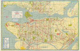
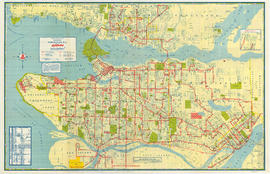
Map of City of Vancouver, British Columbia
Part of City of Vancouver Archives technical and cartographic drawing collection
Part contains a zoning map showing city streets, residential, apartment, commercial and industrial districts, as well as City-owned parks and golf courses. Concentric circles spaced a mile apart on the map emanate from a point in downtown Vancouver.

Vancouver - the third largest city of the dominion, and Canada's chief Pacific port
Part of City of Vancouver Archives technical and cartographic drawing collection
Part contains information on Vancouver's history and government, and on the purpose and benefits of town planning.
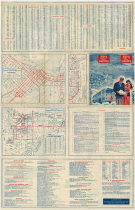
B.C. Electric guide to Greater Vancouver
Part of City of Vancouver Archives technical and cartographic drawing collection
Part is the front side of a folded brochure containing information on the BC Electric transit system in Vancouver. This side includes route maps of services in Downtown Vancouver, central New Westminster, and Richmond. This side also includes a street index
Transit system map of Greater Vancouver
Part of City of Vancouver Archives technical and cartographic drawing collection
Part is a map showing the routes of various BC Electric transit services. The inset map shows the Forest Hills/Canyon Heights area. The map also includes a guide to Vancouver street numbers.

Wrigley's 1930 map of Vancouver and Lower Mainland
Part of City of Vancouver Archives technical and cartographic drawing collection
Part contains a map of Greater Vancouver showing streets, paved streets, trails, street car lines, bus lines, railways, auto camps, hospitals, schools and block numbers. Concentric circles spaced one mile apart emanate from a point in downtown Vancouver.

Street index of Vancouver and Lower Mainland
Part of City of Vancouver Archives technical and cartographic drawing collection
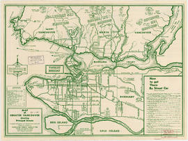
Map of Greater Vancouver showing principal streets
Part of City of Vancouver Archives technical and cartographic drawing collection
Part is a map showing the locations of landmarks and local tourist attractions including Hollyburn, Grouse and Seymour ski grounds. There are two insets, one titled "Distances from the Tourist Bureau," and the other, "How to get There By Street Car."

Points of interest and directions
Part of City of Vancouver Archives technical and cartographic drawing collection
Part is the verso of the brochure, containing information about Vancouver's history and attractions. Also included are images of Lions Gate Bridge, City Hall, Brockton Point, Stanley Park, Hotel Vancouver, Capilano Suspension Bridge and Georgia Street.
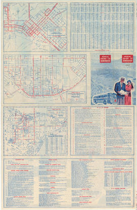
B.C. Electric guide to Greater Vancouver
Part of City of Vancouver Archives technical and cartographic drawing collection
Part is the front side of a folded brochure containing information on the BC Electric transit system in Vancouver. This side includes route maps of services in Downtown Vancouver, central New Westminster, and Richmond. This side also includes a street ind

Transit system map of Greater Vancouver
Part of City of Vancouver Archives technical and cartographic drawing collection
Part is a map showing the routes of various BC Electric transit services. The inset map shows the Forest Hills/Canyon Heights area. The map also includes a guide to Vancouver street numbers.

City of Vancouver : Canadian Pacific town site
Part of City of Vancouver Archives technical and cartographic drawing collection
Part contains four maps. The main map shows district lots and block numbers in Vancouver from Vine Street in the west to Boundary Avenue (Glen Drive) in the east and Stanley Park in the north to 9th Avenue (Broadway) in the south. Three smaller maps include an index plan to district lots in Vancouver, South Vancouver, New Westminster, and Burnaby; a world map showing Canadian Pacific mail steamship lines; and an index plan of Vancouver city limits.
![Vancouver, B.C., the Pacific coast terminus of the C.P.R. [Canadian Pacific Railway]](/uploads/r/null/8/3/f/83fcf65f0d66d64e6357d0d647e0ea6e2fa4aae4c3d1919f952d7725b4299cda/623e750c-fbab-43b7-a496-d20b384baeb6-LEG1321_142.jpg)
Vancouver, B.C., the Pacific coast terminus of the C.P.R. [Canadian Pacific Railway]
Part of City of Vancouver Archives technical and cartographic drawing collection
Part contains text and engravings describing Vancouver's climate, resources, industries, and buildings. Cover page is stamped "Arthur McMullen."

Guide map : Vancouver, New Westminster, Burnaby and North Shore municipalities : street index
Part of City of Vancouver Archives technical and cartographic drawing collection

Guide map : Vancouver, New Westminster, Burnaby and North Shore municipalities
Part of City of Vancouver Archives technical and cartographic drawing collection
Part contains a map of Greater Vancouver showing city streets, schools, firehalls, parks and golf courses, railways, street railways and interurban lines, hospitals and bus routes.
Map of Delta, Langley, Richmond and Surrey
Part of City of Vancouver Archives technical and cartographic drawing collection
Part is a street map of the Delta, Langley, Richmond and Surrey municipalities. The map includes a road and street index.
Agency Press Limited
Street map of Greater Vancouver
Part of City of Vancouver Archives technical and cartographic drawing collection
Part is a street map of Greater Vancouver, from Coquitlam westward and north of the Fraser River. The sheet includes inset maps of Downtown Coquitlam, Gleneagles to Horseshoe Bay, and Highway 99 from West Vancouver to Squamish. The sheet also includes a s
Agency Press Limited
Map of Greater Vancouver and Lower Mainland area
Part of City of Vancouver Archives technical and cartographic drawing collection
Part is the outer side of the cover in which the attached map was folded. The page includes promotional information on the Vancouver Real Estate Board and the Multiple Listing Service, a list of sites of interest in Vancouver, and an amortization table.
Greater Vancouver recreation sites and parks
Part of City of Vancouver Archives technical and cartographic drawing collection
Part is the inner side of the cover in which the attached map was folded. The page includes lists of various types of recreational sites and parks in Vancouver, Burnaby, New Westminster, North Vancouver and West Vancouver.

Part of City of Vancouver Archives technical and cartographic drawing collection
Part contains an illustrated map of Greater Vancouver showing major streets and tourist attractions.

Visitors map of Vancouver ; world famous Stanley Park ; downtown Vancouver
Part of City of Vancouver Archives technical and cartographic drawing collection
Part contains detail maps of Stanley Park and downtown Vancouver, tourist information including traffic rules, locations of churches, golf courses, and amenities, and a list of member businesses of the Vancouver Tourist Association.
Part of City of Vancouver Archives technical and cartographic drawing collection
Part is the enclosed tourist map of Vancouver, including a street index. Map contains a dial which denotes distance from the Yale Hotel.
With compliments and greetings of the management and staff of the Yale Hotel and Yale Gardens
Part of City of Vancouver Archives technical and cartographic drawing collection
Part is the outer side of the cover, in which the map was attached map was folded.
Part of City of Vancouver Archives technical and cartographic drawing collection
Part is the inner side of the cover, in which the map was attached map was folded. The page lists dancehalls and licensed hotels in the City of Vancouver.

B.C. Electric guide to Greater Vancouver
Part of City of Vancouver Archives technical and cartographic drawing collection
Part is the front side of a folded brochure containing information on the BC Electric transit system in Vancouver. This side includes route maps of services in Downtown Vancouver, central New Westminster, and Richmond. This side also includes a street ind
Transit system map of Greater Vancouver
Part of City of Vancouver Archives technical and cartographic drawing collection
Part is a map showing the routes of various BC Electric transit services. The inset map shows the Forest Hills/Canyon Heights area. The map also includes a guide to Vancouver street numbers.
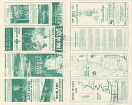
Let's go see! Inside Vancouver
Part of City of Vancouver Archives technical and cartographic drawing collection
Part is the front side of a tourist brochure. The page includes information of tourism sites on the North Shore, including Capilano Canyon, Grouse Mountain, Mount Seymour Park, and general information on the area.

Part of City of Vancouver Archives technical and cartographic drawing collection
Part is the back side of a tourist brochure. The sheet contains four maps, for the Trans-Canada Highway, Stanley Park, Vancouver Island, and Greater Vancouver.
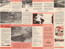
The Port of Vancouver, British Columbia
Part of City of Vancouver Archives technical and cartographic drawing collection
Part is the front side of a brochure on the Port of Vancouver. The page includes information on the port's history, facilities, berthing accommodations, development and

Part of City of Vancouver Archives technical and cartographic drawing collection
Part is a sheet depicting 2 maps, showing Burrard Inlet and major connecting traffic infrastructure, and 5 photographs of port facilities.
Map of Delta, Langley, Richmond and Surrey
Part of City of Vancouver Archives technical and cartographic drawing collection
Part is a street map of the Delta, Langley, Richmond and Surrey municipalities. The map includes a road and street index.
Agency Press Limited
Street Map of Greater Vancouver
Part of City of Vancouver Archives technical and cartographic drawing collection
Part is a street map of Greater Vancouver, from Coquitlam westward and north of the Fraser River. The sheet includes inset maps of Downtown Coquitlam, Gleneagles to Horseshoe Bay, and Highway 99 from West Vancouver to Squamish. The sheet also includes a s
Agency Press Limited
Map of Greater Vancouver and Lower Mainland area
Part of City of Vancouver Archives technical and cartographic drawing collection
Part is the outer side of the cover in which the attached map was folded. The page includes promotional information on the Vancouver Real Estate Board and the Multiple Listing Service, a list of sites of interest in Vancouver, and an amortization table.
Greater Vancouver recreation sites and parks
Part of City of Vancouver Archives technical and cartographic drawing collection
Part is the inner side of the cover in which the attached map was folded. The page includes lists of various types of recreational sites and parks in Vancouver, Burnaby, New Westminster, North Vancouver and West Vancouver.
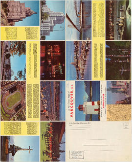
Where to go, what to do, how to see Vancouver
Part of City of Vancouver Archives technical and cartographic drawing collection
Part consists of photographs of prominent tourist sites in Vancouver, with accompanying descriptive text.

Vancouver, British Columbia, Canada
Part of City of Vancouver Archives technical and cartographic drawing collection
Part is a pictorial map noting the locations of main tourist sites described on the other side of the sheet. The sheet includes an index of points of special interest.
Bloodgood, Don

Map of the municipalities of New Westminster City and District, British Columbia
Part of City of Vancouver Archives technical and cartographic drawing collection
Part contains a map of the Lower Mainland and Fraser Valley from the Gulf of Georgia in the west to Harrison Lake in the east. Map shows locations of churches, schools, canneries, sawmills, brickyards, tanneries, woolen mills and hatcheries; existing and proposed railways; and roadways.

Part of City of Vancouver Archives technical and cartographic drawing collection
Part contains information on Delta, Chilliwhack [sic], Surrey, New Westminster, Maple Ridge, Langley, and British Columbia.

Part of City of Vancouver Archives technical and cartographic drawing collection
Part contains a map of Greater Vancouver showing the locations of Bekins Moving and Storage, distances from the Burrard Street and York Street location and city streets. Part includes four photographic images of points of interest in Vancouver.

Map of Vancouver, Burnaby, New Westminster, British Columbia : street index and advertisements
Part of City of Vancouver Archives technical and cartographic drawing collection
Part contains a street index for the main map of Vancouver on the other side of the sheet, advertisements for Bekins Moving and Storage and Allied Van Lines, and three maps showing the companies' service areas in the United States, Canada, and British Columbia and Alberta. An annotation reads: "Oppenheimer collection."

Part of City of Vancouver Archives technical and cartographic drawing collection
Part is the front page of a fold-out brochure advertising Spencer's Department Store, Spencer's furs, and David Spencer Ltd. The page includes an oblique aerial map of the Lower Mainland, and a road map of routes into Greater Vancouver from the south and

Part of City of Vancouver Archives technical and cartographic drawing collection
Part is a sheet with two maps. The main map shows major roads in the Lower Mainland, with Spencer's Department Store illustrated, and points of interest noted. The inset map shows major roads and points of interest in Victoria.
B.C. Electric guide to Greater Vancouver
Part of City of Vancouver Archives technical and cartographic drawing collection
Part is the front side of a folded brochure containing information on the BC Electric transit system in Vancouver. This side includes route maps of services in Downtown Vancouver, central New Westminster, and Richmond. This side also includes a street ind
Transit system map of Greater Vancouver
Part of City of Vancouver Archives technical and cartographic drawing collection
Part is a map showing the routes of various BC Electric transit services. The inset map shows the Forest Hills/Canyon Heights area. The map also includes a guide to Vancouver street numbers.
![Howe Sound - Burrard Inlet [Howe Sound portion]](/uploads/r/null/7/a/1/7a1896077ddc37a7e16ac2d7e42a66031e13e11a9d966c43fca06cbb56f8bd96/5edd8d92-d3cd-4663-8fdd-996b3ae7a402-MAP30a_142.jpg)
Howe Sound - Burrard Inlet [Howe Sound portion]
Part of City of Vancouver Archives technical and cartographic drawing collection
Part shows the Lower Mainland and Howe Sound from Britannia Beach in the northwest to Indian Arm in the southeast. Map shows topographic contour lines, elevations, lakes, streams and other natural features, roads, railways, communication lines, cities and other settlements, and land, timber, and mineral surveys by number.
![Howe Sound - Burrard Inlet [Burrard Inlet portion]](/uploads/r/null/f/8/5/f8523992bb5d5e0c1391f2dea183041a54a2d2470eb4047bb29958a0d835ae95/fdf9563d-923e-468a-a494-3ff190294b91-MAP30b_142.jpg)
Howe Sound - Burrard Inlet [Burrard Inlet portion]
Part of City of Vancouver Archives technical and cartographic drawing collection
Part shows the Lower Mainland and Burrard Inlet from Howe Sound in the west to Indian Arm in the east. Map shows topographic contour lines, elevations, lakes, streams and other natural features, roads, railways, communication lines, cities and other settlements, and land, timber, and mineral surveys by number. Includes a list of sources of information.

Map of West Vancouver and vicinity
Part of City of Vancouver Archives technical and cartographic drawing collection
Part contains a map of West Vancouver, North Vancouver, and the northern parts of Vancouver and Burnaby. Map shows district lot and block numbers, streets, and distances from City Hall.
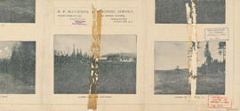
Map of West Vancouver and vicinity : verso
Part of City of Vancouver Archives technical and cartographic drawing collection
Part contains promotional images of West Vancouver and an advertisement for R.P. Matheson Advertising Service.

City of Vancouver : Canadian Pacific town site
Part of City of Vancouver Archives technical and cartographic drawing collection
Part contains four maps. The main map shows district lots and block numbers in Vancouver from Vine Street in the west to Boundary Avenue (Glen Drive) in the east and Stanley Park in the north to 9th Avenue (Broadway) in the south. Three smaller maps include an index plan to district lots in Vancouver, South Vancouver, New Westminster, and Burnaby; a world map showing Canadian Pacific mail steamship lines; and an index plan of Vancouver city limits. Part has been annotated with text describing a June 1888 land clearance plan and hand colouring indicating clearance status.
![Vancouver, B.C., the Pacific coast terminus of the C.P.R. [Canadian Pacific Railway]](/uploads/r/null/e/2/c/e2cdc004f3cf462100ed2ef053aa6087887b3f3200917cd5fba6292afb3b2d2d/bfcde3fa-32d7-4d08-86e5-ecf70c6f8388-LEG1340_142.jpg)
Vancouver, B.C., the Pacific coast terminus of the C.P.R. [Canadian Pacific Railway]
Part of City of Vancouver Archives technical and cartographic drawing collection
Part contains text and engravings describing Vancouver's climate, resources, industries, and buildings.