Print preview Close

Showing 1835 results

Archival description
City of Vancouver Archives technical and cartographic drawing collection
Print preview View:

1440 results with digital objects Show results with digital objects

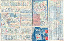
B.C. Electric guide to Greater Vancouver : Richmond transit system, downtown Vancouver transit system, street index, and general information

Part contains maps of the Richmond and downtown Vancouver transit systems, a street index to the Greater Vancouver map on the other side of the sheet, information on B.C. Electric transit routes, and general tourist information.

B.C. Electric plan showing bus stops in Vancouver

Item contains three maps showing transit routes, bus stops and bus zones in the city of Vancouver. Inset maps show the "Seasonal 'round the park route and stops" in Stanley Park and the "University bus route" in the University Endowment Lands. The main map extends from Smith Avenue to Burrard Inlet to Blanca Street to Marine Drive.

B.C. Electric Railway lines completed and under construction

Map shows B.C. Electric Railway lines completed (in red), B.C. Electric Railway lines under construction (in yellow), lot numbers and major roads in the Greater Vancouver area from Burrard Inlet in the north to the north arm of the Fraser River in the south and from New Westminster in the east to Point Grey in the west.

Beautiful Stanley Park

Item is a brochure for tourists on Stanley park. The front sheet of the unfolded pamphlet includes text on attractions, as well as photographs of the park, petting zoo, monuments, trails and gardens, and Malkin Bowl. The reverse of the sheet contains a map of the park, showing roads, trails, geographical features and attractions.

Bottom left plate

Part depicts text and accompanying diagram on "the art of dialing by a common globe", a chart of universal scale, a map of the world using Mercator's projection, a map of the southern half of the Americans, descriptions of the various maps and charts, and the left-hand side of a map of the lunar surface viewable from Earth.

Dunn, Samuel

Bottom right plate

Part depicts the right-hand side of a map of the lunar surface viewable from Earth, a chart of the Analemma, a chart and accompanying text entitled "the vicissitude of seasons explained", a chart and accompanying text on "the art of dialing by a common globe", and a map of the southern portion of Africa and Asia, as well as Australia.

Dunn, Samuel

British Columbia

Item is a modern photocopy of a map showing the southwest portion of British Columbia and the northwest part of Washington State. The map depicts settlements, geographical features, wagon roads, bridle paths and other man-made features. Prepared under the direction of Capt. Persona, R.E. by order of Col. R.C. Moody, R.E.

British Columbia

Item is a re-published version of a geographical map originally published by the Colony of British Columbia, Office of Lands and Works. The map shows topography as hacheurs, and depicts fur trade trails and forts and physical features of the area which made up the Colony of British Columbia as of 1862.

British Columbia : an historical illustrated map commemorating two centenaries, 1867-1967, 1866-1966

Item is an illustrated map is of the province of British Columbia, created to commemorate the Canadian Centennial.

The central component of the sheet is a reproduction of part of a map from the Department of Lands; surrounding the map are illustrations depicting prominent historical figures and accompanying information. The map has been annotated with the routes of Captain Cook's voyage (1778-1779), Captain Vancouver's voyage (1792-1794), and the overland routes of Sir Alexander MacKenzie (1793), David Thompson (1806-1811) and Simon Fraser (1808).

Portraits, accompanied by short biographies, are included for Cook, Vancouver, MacKenzie, Fraser and Sir James Douglas. Six other portraits are of the early governors of the colony of Vancouver Island and of British Columbia between 1849 and 1876. An illustration of the Great Seal of the Realm attached to the royal commission appointing Richard Blanshard the first governor of the colony of Vancouver Island is shown. A short textual description of the birth and expansion of British Columbia is included with an accompanying illustration of the expansion of the province over time.

British Columbia : Port Moody sheet : west of seventh, east and west of coast meridians

Item is a map of the Lower Mainland of British Columbia, from the international border in the south to Britannia Beach in the north and from Sechelt Peninsula in the west to Chilliwack and Harrison Lake in the east. Map shows railways, railway stations, trails, roads surveyed, post offices, townships, and ranges.

British Columbia Electric Railway Company Limited : Vancouver and New Westminster city and suburban lines and Alouette-Stave development, present and projected

Part contains a map showing street car, interurban, and motor bus lines in from Vancouver to New Westminster, a map showing existing and projected power plants near Alouette and Stave Lakes, and a profile showing the existing and proposed plants.

British Columbia federal constituencies

Item is a map sheet with two maps and data regarding federal constituencies in British Columbia. The principal map shows the boundaries of the constituencies. The secondary map is a detail map showing the boundaries in constituencies in Greater Vancouver. The constituency data includes the number of voters in each constituency, the number of votes cast in the 1940 election, and each candidate's name.

British Columbia. Port Moody

Item is a map showing subdivisions of townships in Coquitlam, Port Moody, Pitt Meadows, Surrey, Langley, Sumas, Sardis and Chilliwack. The west coast of British Columbia from Burrard Inlet to the Sechelt peninsula is shown as well as Vancouver Island and the surrounding Gulf Islands. Trails, post offices and railway stations are included.

Results 51 to 100 of 1835