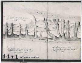
![Sketch of part of line of waggon [sic] road from "Boston Bar" to "Yale"](/uploads/r/null/6/8/5/685aeba6eb70cf489e3dc55456603ed30b0d42c00326cb69f8eb8fa758e030aa/714b3ee8-af5a-4786-85f4-230287a8d5fa-LEG1800_142.jpg)
Sketch of part of line of waggon [sic] road from "Boston Bar" to "Yale"

Sketch of part of line of road along right bank of "Fraser River" from "Boston Bar" to "Yale"

Haro Strait and middle channel

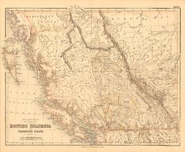
British Columbia
Unidentified portion of Fraser River shoreline

North America. West Coast. Fraser River and Burrard Inlet

British Columbia
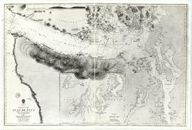
Strait of Juan de Fuca

Vancouver Island and adjacent shores of British Columbia

Portion of Burrard Inlet

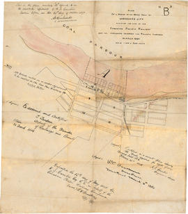
Town of Granville, Burrard Inlet, B.C.

Lower Mainland, B.C. : land subdivision
![[Vancouver, B.C. : district lots]](/uploads/r/null/4/a/4a5c15633319c3754d3aa0cc525470bfebcf5a98ad8caeedf44b777194f300bd/2f055d65-47f7-4679-bb91-66b8f1843d2f-MAP531_142.jpg)
[Vancouver, B.C. : district lots]

Map from the Pacific Ocean across the Rocky Mountain zone
![Chart of Nepigon [Nipigon] Bay. Lake Superior](/uploads/r/null/e/6/0/e6083525f33c7a6d0dd05f840915433768b0cfaed2c5b564153e3bfb5830f77e/8dd4e8d6-c36f-488f-a1bb-7aea7e098200-LEG1153_142.jpg)
Chart of Nepigon [Nipigon] Bay. Lake Superior

Plan of the Kaminstiquia River and Plan showing survey and soundings of Lake Ellen and Nipigon Bay

Map to accompany the report on the Exploration Survey of the Canadian Pacific Railway
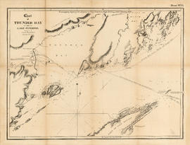
Chart of Thunder Bay. Lake Superior

Sketch plan of the mouth of the Saskatchewan River, from Hinds Exploring Expedition

Chart of the coast of British Columbia, north of latitude 51 degrees

Map of New Westminster District, B.C

Map of portion New Westminster District

Map of Manitoba, Keewatin, British Columbia, and North West Territory

Plan of New Westminster City and suburban lots

Town-site of Hastings

Plan 3

Map of Manitoba, Kewaydin, British Columbia and North West Territory shewing the country traversed by the Canadian Pacific Railway
British Columbia and Vancouver Island

Port Moody, the western terminus of the Canadian Pacific Railway

Plan of the Town of Port-Moody, British Columbia
![Granville [fire insurance plan]](/uploads/r/null/f/3/1/f31b2fc3e34f1b2e375aa4d1c6089d069e20e5c43e88dd4a753a0ed961acd9c9/e011f916-304f-4655-9c90-c93af236fcbb-MAP334_142.jpg)
Granville [fire insurance plan]
![Granville [Townsite], B.C. Aug., 1885](/uploads/r/null/1/a/4/1a45ddd637fe3f3726748d5096017a8461446b9a013c408ed2b1666c8433e1f9/405fdc0d-6d88-41b7-937f-36cc7f51518a-MAP553_142.jpg)
Granville [Townsite], B.C. Aug., 1885
Plan of a portion of the water front of Vancouver city

Canadian Pacific Railway. Plan of part of branch line from Port Moody. A point on main line C.P.R. to English Bay, B.C.

Plan of provincial government property to be sold at Victoria by public auction, Monday, January 18th, 1886

Map of New Westminster District, B.C.

Advertisements for Vancouver real estate

Vancouver, B.C., Pacific terminus of the C.P.R.
City of Vancouver. Canadian Pacific town site
![Vancouver, B.C., the Pacific coast terminus of the C.P.R. [Canadian Pacific Railway]](/uploads/r/null/e/2/c/e2cdc004f3cf462100ed2ef053aa6087887b3f3200917cd5fba6292afb3b2d2d/bfcde3fa-32d7-4d08-86e5-ecf70c6f8388-LEG1340_142.jpg)
Vancouver, B.C., the Pacific coast terminus of the C.P.R. [Canadian Pacific Railway]

Map and information concerning the City and District of New Westminster and Province of British Columbia

City of Vancouver : Canadian Pacific town site

Map of the municipalities of New Westminster City and District, British Columbia

Information concerning the City and District of New Westminster and the Province of British Columbia
![Vancouver, B.C., the Pacific coast terminus of the C.P.R. [Canadian Pacific Railway]](/uploads/r/null/8/3/f/83fcf65f0d66d64e6357d0d647e0ea6e2fa4aae4c3d1919f952d7725b4299cda/623e750c-fbab-43b7-a496-d20b384baeb6-LEG1321_142.jpg)
Vancouver, B.C., the Pacific coast terminus of the C.P.R. [Canadian Pacific Railway]

Plan of the town of Newcastle, English Bay

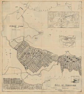
City of Vancouver

City of Vancouver : Canadian Pacific town site

Map of the municipalities of New Westminster, British Columbia

City of Vancouver, Canadian Pacific Town Site