Showing 87 results
Archival description
Sectional map of Vancouver showing streets, block and lot outlines, and building perimeters : Map 15 : Rupert Street to Boundary Road and Pender Street to Kitchener Street
Sectional map of Vancouver showing streets, block and lot outlines, and building perimeters : Map 17 : Nanaimo Street to Rupert Street and Pender Street to Charles Street
Sectional map of Vancouver showing streets, block and lot outlines, and building perimeters : Map 18 : Nanaimo Street to Rupert Street and Charles Street to 5th Avenue
Sectional map of Vancouver showing streets, block and lot outlines, and building perimeters : Map 23 : Balaclava Street to Maple Street and English Bay to 3rd Avenue
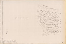
Sectional map of Vancouver showing streets, block and lot outlines, and building perimeters : Map 26 : University Endowment Lands to Blanca Street and N.W. Marine Drive to 4th Avenue
Sectional map of Vancouver showing streets, block and lot outlines, and building perimeters : Map 34 : Nanaimo Street to Rupert Street and 5th Avenue to Grandview Highway North

Sectional map of Vancouver showing streets, block and lot outlines, and building perimeters : Map 36 : Rupert Street to Boundary Road and Grandview Highway to 22nd Avenue
Sectional map of Vancouver showing streets, block and lot outlines, and building perimeters : Map 39 : Nanaimo Street to Rupert Street and 22nd Avenue to Kingsway/Vanness Avenue

Sectional map of Vancouver showing streets, block and lot outlines, and building perimeters : Map 47 : 29th Avenue at King Edward Avenue to Blenheim Street and King Edward Avenue to 33rd Avenue

Sectional map of Vancouver showing streets, block and lot outlines, and building perimeters : Map 56 : Joyce Street/Doman Street to Boundary Road and Kingsway to 49th Avenue

Sectional map of Vancouver showing streets, block and lot outlines, and building perimeters : Map 61 : Cypress Street to Oak Street and 33rd Avenue to 41st Avenue

Sectional map of Vancouver showing streets, block and lot outlines, and building perimeters : Map 63 : Carnarvon Street to Cypress Street and 33rd Avenue to 41st Avenue

Sectional map of Vancouver showing streets, block and lot outlines, and building perimeters : Map 72 : Oak Street to Quebec Street and 46th Avenue to 57th Avenue

Sectional map of Vancouver showing streets, block and lot outlines, and building perimeters : Map 74 : Inverness Street to Nanaimo Street and 49th Avenue to 61st Avenue

Sectional map of Vancouver showing streets, block and lot outlines, and building perimeters : Map 76 : Kerr Street to Boundary Road and 49th Avenue/48th Avenue to Rosemont Drive

Sectional map of Vancouver showing streets, block and lot outlines, and building perimeters : Map 85 : Laburnum Street to Fremlin Street and 57th Avenue to 68th Avenue/67th Avenue

Sectional map of Vancouver showing streets, block and lot outlines, and building perimeters : Map 87 : Barnard Street to Heather Street and 75th Avenue/Kent Avenue South to the North Arm of the Fraser River

Sectional map of Vancouver showing streets, block and lot outlines, and building perimeters : Map 88 : MacDonald Street to Laburnum Street/Angus Drive and 57th Avenue to the North Arm of the Fraser River

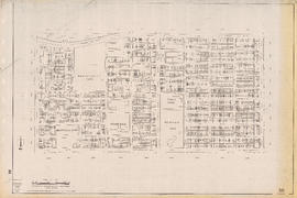
West End local area
Sectional map of Vancouver showing streets, block and lot outlines, and building perimeters : Map 7 : Burrard Street to Main Street and Burrard Inlet to Georgia Street

Sectional map of Vancouver showing streets, block and lot outlines, and building perimeters : Map 10 : Clark Drive to Nanaimo Street and Burrard Inlet to Frances Street/Ferndale Street
Sectional map of Vancouver showing streets, block and lot outlines, and building perimeters : Map 16 : Rupert Street to Boundary Road and Kitchener Street to 5th Avenue
Sectional map of Vancouver showing streets, block and lot outlines, and building perimeters : Map 21 : False Creek waterfront and adjacent buildings from foot of Drake Street to Main Street
Sectional map of Vancouver showing streets, block and lot outlines, and building perimeters : Map 25 : Blanca Street to Jericho Beach Park and English Bay to 4th Avenue
Sectional map of Vancouver showing streets, block and lot outlines, and building perimeters : Map 28 : Camosun Street to Balaclava Street and 4th Avenue to 14th Avenue

Sectional map of Vancouver showing streets, block and lot outlines, and building perimeters : Map 29 : Balaclava Street to Maple Street and 3rd Avenue to 14th Avenue

Sectional map of Vancouver showing streets, block and lot outlines, and building perimeters : Map 30 : Maple Street to Oak Street and 3rd Avenue/6th Avenue to 14th Avenue

Sectional map of Vancouver showing streets, block and lot outlines, and building perimeters : Map 31 : Oak Street to Main Street and 6th Avenue/4th Avenue to 16th Avenue
Sectional map of Vancouver showing streets, block and lot outlines, and building perimeters : Map 38 : Nanaimo Street to Rupert Street and Grandview Highway to 22nd Avenue

Sectional map of Vancouver showing streets, block and lot outlines, and building perimeters : Map 45 : Discovery Street/Camosun Street to Blenheim Street and 14th Avenue to King Edward Avenue

Sectional map of Vancouver showing streets, block and lot outlines, and building perimeters : Map 53 : Inverness Street to Nanaimo Street and 32nd Avenue to 41st Avenue

Sectional map of Vancouver showing streets, block and lot outlines, and building perimeters : Map 54 : Nanaimo Street to McHardy Street/Cecil Street/Joyce Street and Ward Street/Euclid Avenue/Vanness Avenue to 41st Avenue

Sectional map of Vancouver showing streets, block and lot outlines, and building perimeters : Map 59 : Quebec Street to Inverness Street and 37th Avenue to 47th Avenue

Sectional map of Vancouver showing streets, block and lot outlines, and building perimeters : Map 64 : Balaclava Street to Cypress Street and 41st Avenue to 49th Avenue

Sectional map of Vancouver showing streets, block and lot outlines, and building perimeters : Map 65 : Camosun Street to Carnarvon Street and 33rd Avenue to 41st Avenue

Sectional map of Vancouver showing streets, block and lot outlines, and building perimeters : Map 70 : Macdonald Street to Cypress Street and 49th Avenue to 57th Avenue

Downtown peninsula
Results 51 to 87 of 87
- « Previous
- 1
- 2