
- PUB-: PD 2103-: LEG1354.05
- Part
- 1990
Part of City publications collection
11168 results with digital objects Show results with digital objects
Part of City publications collection

City of Vancouver, B.C. area map : Inverness Street to Boundary Road and 32nd Avenue to 54th Avenue
Part of City publications collection

Part of City publications collection

City of Vancouver, B.C. area map : Maple Street to Heatley Avenue and Burrard Inlet to 6th Avenue
Part of City publications collection

Tidal current chart, Vancouver Harbour : one hour after maximum flood at First Narrows
Part of City of Vancouver Archives technical and cartographic drawing collection

Tidal current chart, Vancouver Harbour : two hours after maximum flood at First Narrows
Part of City of Vancouver Archives technical and cartographic drawing collection

Tidal current chart, Vancouver Harbour : three hours after maximum flood at First Narrows
Part of City of Vancouver Archives technical and cartographic drawing collection

Tidal current chart, Vancouver Harbour : one hour before maximum flood at First Narrows
Part of City of Vancouver Archives technical and cartographic drawing collection

Tidal current chart, Vancouver Harbour : two hours before maximum flood at First Narrows
Part of City of Vancouver Archives technical and cartographic drawing collection

Tidal current chart, Vancouver Harbour : maximum flood at First Narrows
Part of City of Vancouver Archives technical and cartographic drawing collection

Tidal current chart, Vancouver Harbour : three hours after maximum ebb at First Narrows
Part of City of Vancouver Archives technical and cartographic drawing collection

Tidal current chart, Vancouver Harbour : one hour after maximum ebb at First Narrows
Part of City of Vancouver Archives technical and cartographic drawing collection

Tidal current chart, Vancouver Harbour : two hours after maximum ebb at First Narrows
Part of City of Vancouver Archives technical and cartographic drawing collection

Tidal current chart, Vancouver Harbour : one hour before maximum ebb at First Narrows
Part of City of Vancouver Archives technical and cartographic drawing collection

Tidal current chart, Vancouver Harbour : two hours before maximum ebb at First Narrows
Part of City of Vancouver Archives technical and cartographic drawing collection

Tidal current chart, Vancouver Harbour : maximum ebb at First Narrows
Part of City of Vancouver Archives technical and cartographic drawing collection

Map of Greater Vancouver and environs showing principal auto roads and highways
Part of City of Vancouver Archives technical and cartographic drawing collection
Part contains a map of Greater Vancouver showing major roads, parks, lakes, mountains, beaches, and distances from the post office.

Map of down-town retail business section
Part of City of Vancouver Archives technical and cartographic drawing collection
Part contains a map of downtown Vancouver showing streets and businesses, and information on industry in Vancouver and British Columbia.

City of Vancouver : Canadian Pacific town site
Part of City of Vancouver Archives technical and cartographic drawing collection
Part contains four maps. The main map shows district lots and block numbers in Vancouver from Vine Street in the west to Boundary Avenue (Glen Drive) in the east and Stanley Park in the north to 9th Avenue (Broadway) in the south. Three smaller maps include an index plan to district lots in Vancouver, South Vancouver, New Westminster, and Burnaby; a world map showing Canadian Pacific mail steamship lines; and an index plan of Vancouver city limits. Part has been annotated with text describing a June 1888 land clearance plan and hand colouring indicating clearance status.

Sale of municipal lands : Point Grey : map showing location of lots to be sold
Part of City of Vancouver Archives technical and cartographic drawing collection

Plan of the Vancouver Exhibition grounds
Part of City of Vancouver Archives technical and cartographic drawing collection
Part contains a map showing the layout and location of the Vancouver Exhibition grounds, and an index to locations on the map.

Wrigley's 1930 map of Vancouver and Lower Mainland
Part of City of Vancouver Archives technical and cartographic drawing collection
Part contains a map of Greater Vancouver showing streets, paved streets, trails, street car lines, bus lines, railways, auto camps, hospitals, schools and block numbers. Concentric circles spaced one mile apart emanate from a point in downtown Vancouver.

Map of West Vancouver and vicinity
Part of City of Vancouver Archives technical and cartographic drawing collection
Part contains a map of West Vancouver, North Vancouver, and the northern parts of Vancouver and Burnaby. Map shows district lot and block numbers, streets, and distances from City Hall.

Circulation map of Greater Vancouver : today's market data on Vancouver
Part of City of Vancouver Archives technical and cartographic drawing collection
Part contains maps and population and circulation data for three areas: Retail City Area, Retail Suburban Area, and All Other Country Area.

Map of Vancouver Sun's city circulation
Part of City of Vancouver Archives technical and cartographic drawing collection

Part of City of Vancouver Archives technical and cartographic drawing collection
Part contains maps of the Richmond and downtown Vancouver transit systems, a street index to the Greater Vancouver map on the other side of the sheet, information on B.C. Electric transit routes, and general tourist information.

Transit system map of Greater Vancouver, B.C.
Part of City of Vancouver Archives technical and cartographic drawing collection
Part contains a map of Greater Vancouver showing bus lines, route numbers, B.C. Electric installations, block numbers, points of interest and amenities; an inset map showing streets in Gleneagles, Whytecliff, and Horseshoe Bay; and an inset map showing streets in Port Moody, Coquitlam, and Maillardville.


Street map of Greater Victoria, B.C., map cover, and street index of Greater Vancouver
Part of City of Vancouver Archives technical and cartographic drawing collection
Part contains a map of Greater Victoria showing highways, streets, parks, golf courses and country clubs, institutions, block numbers, city and municipal boundaries and Shell marine stations, and a street index for the Greater Vancouver map on the other side of the sheet.

Part of City of Vancouver Archives technical and cartographic drawing collection

Street map of Greater Vancouver, B.C.
Part of City of Vancouver Archives technical and cartographic drawing collection
Part contains a map of Greater Vancouver showing highways, streets, parks, golf courses and country clubs, institutions, block numbers, city and municipal boundaries and Shell marine stations.

Street map of Greater Vancouver showing distances from Bekins building
Part of City of Vancouver Archives technical and cartographic drawing collection

Part of City of Vancouver Archives technical and cartographic drawing collection
Part contains a street map of downtown Vancouver, a street map of Vancouver and the Fraser Valley, detail maps showing traffic interchanges corresponding to numbers on the Fraser Valley map, and general tourist information.

Street map of Greater Vancouver, B.C.
Part of City of Vancouver Archives technical and cartographic drawing collection
Part contains a street map of Greater Vancouver showing block numbers, parks, golf courses, cemeteries, and hospitals; inset maps showing streets in Coquitlam and the Horseshoe Bay area; and a map showing Highway 99 from Horseshoe Bay to Squamish.

Part of City of Vancouver Archives technical and cartographic drawing collection
Part contains maps of the Richmond and downtown Vancouver transit systems, a street index to the Greater Vancouver map on the other side of the sheet, information on B.C. Electric transit routes, and general tourist information.

Transit system map of Greater Vancouver, B.C.
Part of City of Vancouver Archives technical and cartographic drawing collection
Part contains a map of Greater Vancouver showing bus lines, route numbers, B.C. Electric installations, block numbers, points of interest and amenities; an inset map showing streets in Gleneagles, Whytecliff, and Horseshoe Bay; and an inset map showing streets in Port Moody, Coquitlam, and Maillardville.

Part of City of Vancouver Archives technical and cartographic drawing collection
Part contains a street map of Greater Vancouver.

Part of City of Vancouver Archives technical and cartographic drawing collection
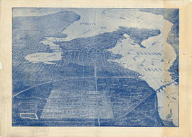
Part contains a map showing street car, interurban, and motor bus lines in from Vancouver to New Westminster, a map showing existing and projected power plants near Alouette and Stave Lakes, and a profile showing the existing and proposed plants.

Part of City of Vancouver Archives technical and cartographic drawing collection
Part contains a map showing major roads from the North Shore to Bellingham, Washington; a map showing major roads in the Victoria area from Cobble Hill in the northwest to Sooke in the southwest; and traffic rules for Vancouver.
Part of City of Vancouver Archives technical and cartographic drawing collection
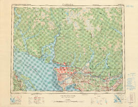
Part contains a map of the Greater Vancouver area showing topographic contour lines at 500-foot intervals, roads and road characteristics, railways, parks, towns, reserves, elevations, airports, streams, lakes, and adminstrative boundaries. Includes a key plan of adjoining sheets published in the same series and a small ancillary map showing the declination of the compass needle in 1958.

British Columbia Electric Railway Company Limited : Vancouver Island system and Mainland system
Part of City of Vancouver Archives technical and cartographic drawing collection
Part contains two maps showing city, suburban, and interurban railway lines, transmission lines, generating stations, substations, and transformers.

Indexed map of Greater Vancouver showing distances from Bekins building
Part of City of Vancouver Archives technical and cartographic drawing collection
![City of Vancouver surrounding [sic] and municipalities including City of New Westminster](/uploads/r/null/8/9/1/8919931915a624a5abd2e5d2953118fdd853654343ce31193f00d341d482bf39/fd6eb299-3e6a-498e-bfd9-62a3279a8861-LEG1329_142.jpg)
City of Vancouver surrounding [sic] and municipalities including City of New Westminster
Part of City of Vancouver Archives technical and cartographic drawing collection
Part contains a street map showing distances from a point in downtown Vancouver, waterfront businesses in Burrard Inlet, street car lines, bus lines, parks, golf courses, schools and hospitals.

Part of City of Vancouver Archives technical and cartographic drawing collection
Part contains a map showing block and lot numbers of properties in the area bounded by Campbell Street (Alma Street), Richards Street (Balaclava Street), English Bay, and present-day 15th Avenue (not named on map).

Part of City of Vancouver Archives technical and cartographic drawing collection
Part contains a street map of Greater Vancouver with street index, an inset map showing the streets of Horseshoe Bay, Whytecliff, and Caulfeild, and advertising Chevron gasolines and RPM motor oils.
Maps of Victoria and Vancouver Island, mileage chart and traffic routes
Part of City of Vancouver Archives technical and cartographic drawing collection
Part contains a street map of Victoria with street index, a map of Victoria and vicinity showing major roads, a map of Vancouver Island showing highways, a mileage chart, and traffic rules for Vancouver and Victoria.

Part of City of Vancouver Archives technical and cartographic drawing collection
Part contains a map of East Vancouver Heights showing streets, block numbers and lot numbers, an index map showing the location of East Vancouver Heights in relation to the rest of the city, and text promoting the area.

Greater Vancouver votes October 17th : know your ward - know your poll
Part of City of Vancouver Archives technical and cartographic drawing collection
Part contains a map showing ward and poll numbers and locations in the City of Vancouver from Burrard Inlet in the north to the Fraser River in the south and from Boundary Road in the east to Blanca in the west. Map has been annotated by Major J.S. Matthews to show mayoralty election results by ward.
Bird's eye view of Vancouver, B.C.
Part of City of Vancouver Archives technical and cartographic drawing collection
Part contains an illustrated oblique view of Vancouver showing steamship lines, bridges, beaches, major roads, and the location and block numbers of East Vancouver Heights.

Greater Vancouver votes October 17th : know your ward - know your poll
Part of City of Vancouver Archives technical and cartographic drawing collection
Part contains a map showing ward and poll numbers and locations in the City of Vancouver from Burrard Inlet in the north to the Fraser River in the south and from Boundary Road in the east to Blanca in the west.