![City Views from City Hall Roof [1 of 24]](/uploads/r/null/8/5/856662885bdcb05dc18466467b60b099174741c5c7f9c8e58e8c9bf1b890fb5d/09978ada-faa3-49d2-ad18-9989250e9d7a-A66804_142.jpg)
City Views from City Hall Roof [1 of 24]
- COV-S663-: CVA 800-2593
- Item
- Apr. 4, 1985
Part of City of Vancouver fonds
925 results with digital objects Show results with digital objects
City Views from City Hall Roof [1 of 24]
Part of City of Vancouver fonds
![City Views from City Hall Roof [2 of 24]](/uploads/r/null/6/4/64e51364908ef4a930564b0576e93119f6468f4ddc6c519d6701d5d198d72bdd/825b1251-eb8b-4f2f-b8c1-6138af90e367-A66805_142.jpg)
City Views from City Hall Roof [2 of 24]
Part of City of Vancouver fonds
![City Views from City Hall Roof [3 of 24]](/uploads/r/null/8/7/870947f27bd17e5bb00091e9365bb5b963d413dfaf0068392f1c0cf277720d3c/54567b90-d12a-481e-9431-559c56816e6f-A66806_142.jpg)
City Views from City Hall Roof [3 of 24]
Part of City of Vancouver fonds
![City Views from City Hall Roof [4 of 24]](/uploads/r/null/8/3/838149b25c50d566912553b7be4eb9b6debbdd7ce2d34231ac89fd3886ab4f2f/b5a750d0-3cca-4c8f-99f9-583fd1e31340-A66807_142.jpg)
City Views from City Hall Roof [4 of 24]
Part of City of Vancouver fonds
![City Views from City Hall Roof [5 of 24]](/uploads/r/null/1/7/17452a8c5a34698be580091565b6f62a777ccd19554ea559eee7838c061408f8/36ebcb3e-ca44-45d4-8956-606ff3add440-A66808_142.jpg)
City Views from City Hall Roof [5 of 24]
Part of City of Vancouver fonds
![City Views from City Hall Roof [6 of 24]](/uploads/r/null/2/c/2c129a24401a15df2ffd2423fe7732f8b97dfff0d6d29e63b0b8b131f2412250/702c1a2e-d423-4a78-a934-8c57691aca81-A66809_142.jpg)
City Views from City Hall Roof [6 of 24]
Part of City of Vancouver fonds
![City Views from City Hall Roof [7 of 24]](/uploads/r/null/9/0/900adf3e242ed8bb0d4f3bd99642c44581c6add77f6bcd53f5536087314fb580/139c5915-54d6-4e0c-80fd-9e6639365c32-A66810_142.jpg)
City Views from City Hall Roof [7 of 24]
Part of City of Vancouver fonds
![Cambie Bridge Construction - #18 [1 of 33]](/uploads/r/null/6/e/6e3ba74e493b6415bef92b068adc38fce2967be050157f4b1aed59de73e36854/dbc8d1f3-f237-4a69-b72d-1ae8b54a232d-A66811_142.jpg)
Cambie Bridge Construction - #18 [1 of 33]
Part of City of Vancouver fonds
Slide shows aerial view of construction of new Cambie Bridge including Downtown and False Creek.
![Cambie Bridge Construction - #18 [2 of 33]](/uploads/r/null/3/4/34e1d5e1a601e98759df0242245128775d150e375757d1298bd0f42bf40d0bd3/90227bce-9ef6-4f93-9226-f8bf655b46c2-A66812_142.jpg)
Cambie Bridge Construction - #18 [2 of 33]
Part of City of Vancouver fonds
Slide shows aerial view of construction of new Cambie Bridge including Downtown and False Creek.
![Cambie Bridge Construction - #18 [3 of 33]](/uploads/r/null/c/d/cdcd44c17c2b364502b5f104403ebdf949902564b3a614fd3635d5ad9ff15308/e4c7f3f4-5d32-4a0b-95d9-8d5af83e8524-A66813_142.jpg)
Cambie Bridge Construction - #18 [3 of 33]
Part of City of Vancouver fonds
Slide shows aerial view of construction of new Cambie Bridge including Downtown and False Creek.
![Cambie Bridge Construction - #18 [4 of 33]](/uploads/r/null/1/6/16c88fcec1ec5acee0246429148a2a64fd695a7449c59cc95748d281ae8adc6d/78c0fe89-0684-4c98-8ea4-0eca386b1ed1-A66814_142.jpg)
Cambie Bridge Construction - #18 [4 of 33]
Part of City of Vancouver fonds
Slide shows aerial view of construction of new Cambie Bridge including Downtown and False Creek.
![Cambie Bridge Construction - #18 [5 of 33]](/uploads/r/null/e/7/e7d572cfcbd5bb83c7f8aad117dd677c521787e10c853a79f4c2b7737f330aa7/651345e7-c7ae-40f4-bf18-a1571796f3d1-A66815_142.jpg)
Cambie Bridge Construction - #18 [5 of 33]
Part of City of Vancouver fonds
Slide shows aerial view of construction of new Cambie Bridge including Downtown.
![Cambie Bridge Construction - #18 [6 of 33]](/uploads/r/null/a/d/add56eb7392e41930d7533a1c3227f2b2ea55a9b901591d98d24c33709362558/2067c19c-0476-48bc-936a-8c2c1027ed3f-A66816_142.jpg)
Cambie Bridge Construction - #18 [6 of 33]
Part of City of Vancouver fonds
Slide shows aerial view of construction of new Cambie Bridge including Downtown.
![Cambie Bridge Construction - #18 [7 of 33]](/uploads/r/null/5/d/5d8554dd15e6c4df58e3e5efc6cd47504da9514c84cfce04adfb6c5f0dde27b3/d84d0ec5-c117-469e-8316-bb6c50632b9b-A66817_142.jpg)
Cambie Bridge Construction - #18 [7 of 33]
Part of City of Vancouver fonds
Slide shows aerial view of construction of new Cambie Bridge.
![Cambie Bridge Construction - #18 [8 of 33]](/uploads/r/null/6/7/67074309c1f9e4c153508701041c7c39e84ce1c9ec97366c90a47340c94d2d15/216e8bed-bb14-4c20-89d3-9241bc666f02-A66818_142.jpg)
Cambie Bridge Construction - #18 [8 of 33]
Part of City of Vancouver fonds
Slide shows aerial view of construction of new Cambie Bridge.
![Cambie Bridge Construction - #18 [9 of 33]](/uploads/r/null/6/b/6b899a7bfa122238d71be0bee6cc7eb15713d49432659b5724177b09c16fd663/1e884466-8f56-44b2-a90d-9f1e06566ef1-A66819_142.jpg)
Cambie Bridge Construction - #18 [9 of 33]
Part of City of Vancouver fonds
Slide shows aerial view of construction of new Cambie Bridge.
![Cambie Bridge Construction - #18 [10 of 33]](/uploads/r/null/c/0/c0d67c9c87297604bbf54ef823839f6652b17b6548b49d2256283ab4c6f665e0/cff8dcf9-0710-4984-9794-9955aec4fc23-A66820_142.jpg)
Cambie Bridge Construction - #18 [10 of 33]
Part of City of Vancouver fonds
Slide shows aerial view of construction of new Cambie Bridge.
![Cambie Bridge Construction - #18 [11 of 33]](/uploads/r/null/b/1/b140e03cf3f8b2768aed842980d14a75ac9bb3a75c96b835483d630b25d328e7/4a9ef95e-6051-4368-93a5-5c25fcb73864-A66821_142.jpg)
Cambie Bridge Construction - #18 [11 of 33]
Part of City of Vancouver fonds
Slide shows aerial view of construction of new Cambie Bridge.
![Cambie Bridge Construction - #18 [12 of 33]](/uploads/r/null/d/9/d912647d27274e8a98f6aa2d55cf8aa5238608bb5543bf4f849ab16ad13cc3c1/233f9972-c2e9-458c-abcb-ab85d415bca9-A66822_142.jpg)
Cambie Bridge Construction - #18 [12 of 33]
Part of City of Vancouver fonds
Slide shows aerial view of construction of new Cambie Bridge.
![Cambie Bridge Construction - #18 [13 of 33]](/uploads/r/null/0/9/096793c65ec76c29979d108ee0c1fb7588b424f5a2b2b84ca8625605da0df0de/a17dea34-d587-4eda-96d2-d6ef5c882d23-A66823_142.jpg)
Cambie Bridge Construction - #18 [13 of 33]
Part of City of Vancouver fonds
Slide shows aerial view of construction of new Cambie Bridge.
![Miscellaneous [103 of 130]](/uploads/r/null/6/b/6b110a5dcb198fe50cd693c08217a7c1e1af4f4a89ec572715d38d5ce6f0cb44/2c71c224-c28e-4366-81f6-a5f00e629bb1-A67535_142.jpg)
Part of City of Vancouver fonds
![Miscellaneous [117 of 130]](/uploads/r/null/a/4/a49076bf7f21e2d357296433bc7fd1ea2256b52579a7bbc9d0d5d8d441bbff5d/e3382963-8663-4ddd-adee-5344f82b64b8-A67549_142.jpg)
Part of City of Vancouver fonds
![Miscellaneous [118 of 130]](/uploads/r/null/5/7/57403a1f4476c4a743cde572f646f29ae76d74f0efe6c90a7b2b5c5a33013fd9/3849ebe1-cc8a-4342-826c-f8c2a4387bd5-A67550_142.jpg)
Part of City of Vancouver fonds
Item is a photograph showing Coal Harbour with the Shell marine fuel dock in the foreground and a cruise ship, a float plane and downtown buildings in the background.
![Granville Mall [149 of 149]](/uploads/r/null/1/d/1d022476e71ee174ec9bb96d1c7e1b490a8d132e88c03cfe7cc5550216262228/adbb7f52-a5ee-4313-a3e6-7b55dc1f1024-A67557_142.jpg)
Part of City of Vancouver fonds
![Granville Street [11 of 11]](/uploads/r/null/f/b/fb7b44425cb8dbf0c56610a281373d07150fbbeb371b4259209f4f0994ddeccd/6ecf53d2-dc39-469a-a7a8-cd8b54de6f41-A67558_142.jpg)
Part of City of Vancouver fonds
![City Views from City Hall Roof [8 of 24]](/uploads/r/null/8/8/88d6733c1dc509360d7b4d91dcc7fb6c7b7fcddf9f76e1b4bc31701b2a27402b/c512facd-ad25-4a76-87db-003fe2aad56d-A67853_142.jpg)
City Views from City Hall Roof [8 of 24]
Part of City of Vancouver fonds
![City Views from City Hall Roof [9 of 24]](/uploads/r/null/3/5/35de332ab1bb6a6986eabb4094f4e9ef3934b4e7d7cf874b87ea91884a4c0790/bdd1c21b-19be-4ecf-b8c4-b44d0d6e679d-A67854_142.jpg)
City Views from City Hall Roof [9 of 24]
Part of City of Vancouver fonds
![City Views from City Hall Roof [10 of 24]](/uploads/r/null/f/f/ff40cf9dbb907db14f1d4219dde54d8987d9b9e2b529611b3f6adde8a5a86bdc/18c92d7d-ff19-4ae4-8936-2c25a81257ba-A67855_142.jpg)
City Views from City Hall Roof [10 of 24]
Part of City of Vancouver fonds
![City Views from City Hall Roof [11 of 24]](/uploads/r/null/a/0/a018839d151ca4930ca9614b7544b42c144e08f545c1771bf1cd47984f66fdb1/b28baada-157a-430e-a277-81d03695e1eb-A67856_142.jpg)
City Views from City Hall Roof [11 of 24]
Part of City of Vancouver fonds
![City Views from City Hall Roof [12 of 24]](/uploads/r/null/f/f/ff69edeeb7418181b4b9d33e095bc7cc21c9af4d0e2554b09c831d3bf1f7bd50/429f6a28-039f-489b-adf6-8ea31d84bd36-A67857_142.jpg)
City Views from City Hall Roof [12 of 24]
Part of City of Vancouver fonds
Photograph shows the construction of a section of the Expo Line SkyTrain Line, BC Place stadium is to the right. The downtown skyline looms to the North.
![City Views from City Hall Roof [17 of 24]](/uploads/r/null/8/8/88d3bef1c1469ce1cc10bc8fbca23f86c609be30d9831d61a4d50c1b4d64bdf2/81e29215-8eee-48b5-96b4-b0b43141da58-A67862_142.jpg)
City Views from City Hall Roof [17 of 24]
Part of City of Vancouver fonds
Photograph depicts the construction of a section of the Expo SkyTrain line.
![City Views from City Hall Roof [18 of 24]](/uploads/r/null/b/8/b8a7473b4694078665501a45fbb5222c49d42eead5c903c6be96a83aa3b99522/4ea08f7e-1727-4cc4-a055-b869b199d0c4-A67863_142.jpg)
City Views from City Hall Roof [18 of 24]
Part of City of Vancouver fonds
Item is a photograph showing the construction of a section of the Expo Line SkyTrain with downtown Vancouver in the background.
![City Views from City Hall Roof [19 of 24]](/uploads/r/null/c/a/ca3d15ba4d81c83975b97928f035237b4425c5a29a6684d52b04ed219a337cd7/a60eb6cc-80da-4e0c-910c-7f061c723c7d-A67864_142.jpg)
City Views from City Hall Roof [19 of 24]
Part of City of Vancouver fonds
Item is a photograph showing the construction of a section of the Expo Line SkyTrain Line with downtown Vancouver and mountains to the North in the background.
![Beautification Problems - #1 [6 of 18]](/uploads/r/null/5/2/52a5fa543e547a81920189dc0e831968be5a540192c7dba1a12c190b9ca38044/368b256b-aad5-4cdb-9f3f-dee00f72789e-A68608_142.jpg)
Beautification Problems - #1 [6 of 18]
Part of City of Vancouver fonds
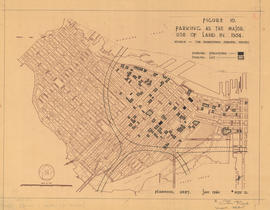
Figure 10 : parking as the major use of land in 1954
Part of City of Vancouver fonds
Map is a plan of downtown Vancouver showing parking structures and parking lots in the area between Jervis Street and Main Street and Burrard Inlet and Nelson Street. The source of the map is indicated as 'The Downtown Parking Report'. Note written in the bottom right corner of the map reads "B 1960 Jan., Traffic Plans, small folder."

Figure 11 : parking as the major use of land in 1959
Part of City of Vancouver fonds
Map is a plan of downtown Vancouver showing parking structures and parking lots in the area between Jervis Street and Main Street and Burrard Inlet and Nelson Street. The source of the map is indicated as an aerial photograph taken April 1959. Note written in the bottom right corner of the map reads "B 1960 Jan., Traffic Plans, small folder."

Figure 12 : parking as the major use of land in 1976
Part of City of Vancouver fonds
Map is a plan of downtown Vancouver showing parking structures and parking lots in the area between Jervis Street and Main Street and Burrard Inlet and Nelson Street. The source of the map is indicated as 'parking supply and demand projections, September 1959'. Note written in the bottom right corner of the map reads "B 1960 Jan., Traffic Plans, small folder."

Figure 15 : a circulation pattern for pedestrians
Part of City of Vancouver fonds
Map is a plan of downtown Vancouver with areas shaded to indicate streets, squares, malls and arcades, in which the movement of vehicles is not permitted at all or is restricted. Although the entire downtown area is shown, shading pertains only to Jervis Street and Main Street and Burrard Inlet and Nelson Street. Note written in the bottom right corner of the map reads "B 1960 Jan., Traffic Plans, small folder."