![[Children and adult at shooting practice]](/uploads/r/null/9/0/90a13dde115513541645feeb95371aa086f142f7cc7ea5f9698e094f09e659d0/be0016bb-6366-46d5-b656-d95f85d3788b-A70037_142.jpg)
[Children and adult at shooting practice]
- VPK-S625-2---: CVA 392-1800.503
- Item
- 1986
665 results with digital objects Show results with digital objects
[Children and adult at shooting practice]
![[Child on ropes course]](/uploads/r/null/4/8/48d2692a531b15958bd44da228f467bce5fb051d147c7d62ea84d0a288fa0098/0fa738d3-352f-4dbf-9fb7-22fea6fa522a-A70038_142.jpg)
![[Child in wheelchair]](/uploads/r/null/7/6/76bd54ea5c5c93f442599264282096042e76888f830d326d5ce33725f111bf58/ebd795fd-7d13-467d-ae95-5b63eb5fe07d-A70039_142.jpg)
![[Boy in wheelchair]](/uploads/r/null/2/5/25028d16320072f52a8a45eb8c235bb4a9658605f6446d190dd2ae2856709838/bafdd545-d6fa-4484-9f19-5a5e6cfbe237-A70040_142.jpg)
![[Children in playground with ropes course]](/uploads/r/null/2/c/2c6726402ee18f27363231f2c58fa755f1fb4d722a18ee4540f2573d3bb79580/836518cd-2ad1-4baf-9693-64a6451bf747-A70041_142.jpg)
[Children in playground with ropes course]
![[Child with headphones in wheelchair]](/uploads/r/null/0/6/06d0bfc41e5c249b291cb55cc4191558ebc4442d80783d308c8dd2941ae2e36e/4af8f8fd-1b67-44c8-9394-dcd495fb600c-A70042_142.jpg)
[Child with headphones in wheelchair]
![[Woman in wheelchair interacting with man]](/uploads/r/null/f/e/fe4bc54490d37cf71a8b834758dd62ecbec4e82bbbb727336cfdc010a6ec1a32/2d53ace0-791c-4056-a8e7-cfe4f1379916-A70043_142.jpg)
[Woman in wheelchair interacting with man]
![[Kids on rope ladder above inflatable mat]](/uploads/r/null/0/2/02945e8db46538bb3113e695b80ef38585deda088a5e0d02436ac662010a0f47/a543f2f5-9597-4775-9f84-127ba3ca7938-A70044_142.jpg)
[Kids on rope ladder above inflatable mat]
![[Boy with golf club in golf net]](/uploads/r/null/0/7/073ed3784cc2fba05826264313e81790354fa3075e8e808b5851b5016c71a07c/e4f5ae04-e5ef-4874-a753-d28cdf9f8e9b-A70045_142.jpg)
[Boy with golf club in golf net]
![[Boy with a baseball bat in batting cage]](/uploads/r/null/4/7/47f418542233d817e23b14226a7901b9c1fa7d924baa075c981b13899b1b68da/90efb3a6-df6f-4b4b-a4b1-0d416d090ed7-A70046_142.jpg)
[Boy with a baseball bat in batting cage]
![[Canadian flags in sports field]](/uploads/r/null/0/b/0b9461951e08817c85ec57b9c36f51840f1f0b7535183796e854cd98925efa8b/7dd25a6f-c738-4b56-959b-6b83c98e15b8-A70047_142.jpg)
[Canadian flags in sports field]
![[Two people in wheelchairs on running track]](/uploads/r/null/3/8/38dc2fef900be816246a069ba3c856e25e614acc7fc67ab1fef18139f332f97d/4727b656-1f68-4d88-8d4a-b875121ced69-A70048_142.jpg)
[Two people in wheelchairs on running track]
![[Shooting practice goalie screen]](/uploads/r/null/b/6/b6b389ef81f194fe8a1de906b8995b566b159fab2d9b6f4c49fbdeba0fcd36b2/5e3b2e5f-d7ce-4f32-9784-ddd9391c7aea-A70049_142.jpg)
[Shooting practice goalie screen]
![[Kids with punching bags]](/uploads/r/null/2/a/2a1ab28424e0198d241e2cea2cd77682b0bd76e0694ee8a29c639ac752b171e6/986cebf8-2364-48b1-bd88-2842b232b80f-A70050_142.jpg)
![[Two people in wheelchairs on running track]](/uploads/r/null/a/2/a2b09c8c8b33ce8cfbeea6244624390a4ee7aae7746cfe7ecd783007df0114fd/d1f0d6e5-9eff-463c-83d4-7142c9c6bc48-A70051_142.jpg)
[Two people in wheelchairs on running track]
![[Man with children in wheelchairs]](/uploads/r/null/f/b/fbc2a1a049cbee6f933d1ee71774b2b04527b0ec73226fc4a1b1c704d3360753/47d37835-15d5-4317-85a7-c95663c3aa5d-A70052_142.jpg)
[Man with children in wheelchairs]
![[Child with grocery bag on ropes course]](/uploads/r/null/5/e/5e212dfb37263a9adea04ea6a405b2dc5c0c227f1b82eae12ec6efe87590e8dc/a25e2621-0924-4268-9027-964c43c42748-A70053_142.jpg)
[Child with grocery bag on ropes course]
![[Person in wheelchair]](/uploads/r/null/8/0/80d45431e9b2c587eb32aee46b7c964d0f3f578a51e63a52eabfa6bd02d75bb4/0143c590-680b-4938-841c-667f3239792f-A70054_142.jpg)
![[Children at shooting practice]](/uploads/r/null/7/f/7fdd477e798621850b7294bff4e06c0482077446b54656e2340e183636ad2480/3f7037a5-4db6-4299-8002-e5240bc9f0dd-A70055_142.jpg)
[Children at shooting practice]
![[People playing volleyball on sports field]](/uploads/r/null/7/4/740acd521eec026f12275398e00b31feeff9365a271a68ab13f2bd6c92b6935d/30eff634-f8b2-42eb-899a-a2b6e5227bdc-A70056_142.jpg)
[People playing volleyball on sports field]

View of Kitsilano Beach, original bathhouse, gazebo and surrounding houses

View of sunbathers on Second Beach

Pruning of trees standing by Oppenheimer Park
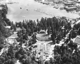
Aerial view of Malkin Bowl, Stanley Park and waterfront industries

Aerial view of Malkin Bowl, Stanley Park and waterfront industries

View of playground at Douglas Park, 20th Avenue at Heather Street

View of Coast Guard station and floating gas station with West End highrise apartments in background

Italian game "Bocce" takes place on Victoria Park
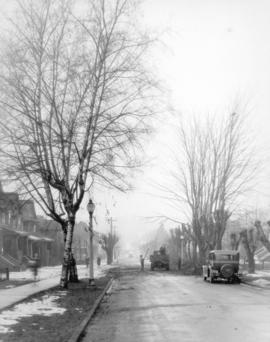
View of tree pruning in progress


Sketch plan showing suggested area for municipal golf links, Vancouver, B.C.
Item is a map showing layout of proposed golf course and topographic contour lines for the area bounded by Victoria Drive, Kerr Street, 59th Avenue, and Marine Drive.
![Plan (in red) showing a suggested bye-pass [sic] road at south end of bridge to avoid cars making...](/uploads/r/null/5/f/a/5fa882ee3603828c85df983159b220e0d7d55438efe1ba4b847e4f6dff6a97f1/dae4a3ae-0095-4c04-bb66-221ef23eeafd-LEG1364_142.jpg)
Item is a map of the Prospect Point area annotated to show a suggested bypass road at the south end of the First Narrows Bridge. Base map shows roadways approaching the proposed First Narrows Bridge, locations of hydrants, topography, and details of landscaping in some areas, and includes two elevations of a proposed skew bridge.
Stanley Park survey - Lost Lagoon
Item is a map showing data from a topographical survey of Lost Lagoon in Stanley Park. The area of the park around the lagoon is depicted, but no topography is indicated.
Item is an architectural design drawing for the English Bay Beach bathhouse. The drawing includes front, north and south elevations; exterior elevations of entrances and windows; and sections.
Vancouver (B.C.). Board of Park Commissioners
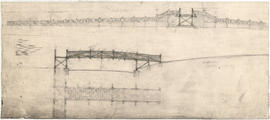
Item is a sketch of a bridge or footbridge, possibly for Stanley Park.
![Plans of proposed improvements for Stanley Park [zoo]](/uploads/r/null/1/2/8/1286e3d551fdc4f6114d7192b398fadf80cd5f81f973f7239a38f213d0fb861f/f85b711c-986e-45d4-9ff2-dcb227c579e4-LEG1969_142.jpg)
Plans of proposed improvements for Stanley Park [zoo]

Plans of proposed pavilion for Stanley Park
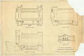
Proposed natatorium for Stanley Park
Item is a rendering of a proposed swimming pool building in or near Stanley Park.
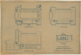
First floor plan and ground [floor] plan
Proposed bird park [Stanley Park]
Proposed Shakespeare Garden in Stanley Park
Item is a rendering for a proposed Shakespeare Garden in Stanley Park.
Thrupp, E.C.

Sharp & Thompson, Architects

Sharp & Thompson, Architects

Site plan and lower ground floor plan
Sharp & Thompson, Architects

Elevations, floor plan and cross-section of swimming baths
Sharp & Thompson, Architects
Item is a drawing depicting three floor plans and a section of a proposed building to house a swimming pool at English Bay.
A.S. Wootton, Civil Engineer
Item is a complete, copy of drawing LEG1969.13, without annotations.
Sharp & Thompson, Architects

Item is a copy of drawing LEG1969.13, which has been annotated to show more detail in the design of interior spaces.

Proposed swimming bath : plan of electrical lighting
Item is a copy of drawing LEG1969.13, which has been annotated to show the locations and type of interior lighting fixtured.