
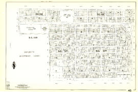
Sheet 39 : Kingsway and Nanaimo Street to Rupert Street and Ward Street to Twenty-second Avenue
- AM1594-MAP 341-: MAP 341.38
- Item
- [1962?], with revisions to Feb. 1967
Part of City of Vancouver Archives technical and cartographic drawing collection
Item is a section showing the area from Kingsway and Nanaimo Street to Rupert Street and Ward Street to Twenty-second Avenue. Includes streets, blocks, lots and legal descriptions, and the locations of parks, schools and railways.
Vancouver (B.C.). Engineering Services


![[School buidling]](/uploads/r/null/4/1/d/41d180811de4ef150e9fc20cbf7713ab4a27b51a03f02ed12164b22e4ad4b47f/8bca8e93-bc97-42e0-a7ad-fa3bccedcee8-CVA1095-08699_142.jpg)
![[School buidling]](/uploads/r/null/f/2/7/f27a9956597ed3eab185566751e605bf55af03aa3414c945f834b796d187c117/d78b3793-55c1-4306-909a-46b53b064c4c-CVA1095-08698_142.jpg)

![[Driveway leading to house]](/uploads/r/null/5/f/a/5fab5a4d90a97322aa344fbaac32665ea61b01c99ff0fecd90f089c808867d15/1bc961f4-d6be-49f9-9b56-5331b1bc7a5b-CVA1095-08696_142.jpg)
![[Corner house]](/uploads/r/null/1/f/f/1ff7292f621c5d3faef0a37be87cabc91230e09a6c9c156ac0d37f4520941f8a/137e1bee-88cc-4c44-bc93-efde42f4f0cf-CVA1095-08695_142.jpg)
![[Lamppost on median]](/uploads/r/null/4/6/1/4614ec629d8ca7d0cc5fc02b351ead6f624bafc95121434058024dbffe73f298/94d04509-6073-4e5c-86a4-fcf688bbe51a-CVA1095-08694_142.jpg)
![[City lookout, possibly along Chancellor Boulevard, 2 of 2]](/uploads/r/null/c/6/d/c6dc2aad70263d1e91a2d0ab75cb2f45967f109c3e92c89adb0692ffda0a495b/4725291a-f337-4fa5-85fd-41ed165d6380-CVA1095-08693_142.jpg)
![[City lookout, possibly along Chancellor Boulevard, 1 of 2]](/uploads/r/null/5/c/b/5cbab1701ebb3167697e9b6d0f393e17c3e37c52aadf93977a4129bd7ec648ad/163ffa2e-bfb5-473f-8654-be14119de72e-CVA1095-08692_142.jpg)
![[House at 1893/1895]](/uploads/r/null/4/f/2/4f21e5f23f332aed9d40206b4a06440930f1dd3a3ef75d6cda7a7a08b991aaa4/376f860f-2682-4a90-80c3-ffa34c4dac05-CVA1095-08691_142.jpg)


![[West Point Grey house]](/uploads/r/null/0/6/d/06df072ee76df683fae2eb26911f784f31db7db01e6a4703ac3de2a4127170e2/3d500d69-f5a6-46c3-b9bc-6e293b38342c-CVA1095-08677_142.jpg)

![[View of 900 block Seymour Street]](/uploads/r/null/8/a/8a5b02b2c474bf4b469da2d909bb54224b911318574331cce7bc62d4574553c8/7f06889b-efed-40ae-b34c-c6615fa12dd1-CVA810-93_142.jpg)


![[Stores on Denman Street]](/uploads/r/null/4/c/4c50ef8af2f205f0da986037226f64b960e8b264d1d6785c129b28a600b9b83b/4252ecbf-7b81-4c5f-99c1-d7b02f1d1061-A09806_142.jpg)
![Miscellaneous [39 of 130]](/uploads/r/null/2/7/2727228414d9291d233b7e03aa7f07086f50d1ac2e0a2859b2c76ea0eccf7f0c/26108bf5-c3d6-4d51-a5d3-37ac2d644038-A64365_142.jpg)
![Miscellaneous [41 of 130]](/uploads/r/null/5/e/5e42ab92f4cae68f59e04f28d6c5796d7a4a008adc11be6e92a097993d27c4cf/850f5829-2350-4212-bfdb-20c86d11b5a2-A64367_142.jpg)
![Miscellaneous [66 of 130]](/uploads/r/null/f/3/f3e5c735d932ae4b6cf5264ac1126704a320ba278c9197a1e374be368226338b/a99fc078-5f61-4e29-b051-d858f0963d35-A64400_142.jpg)
![Miscellaneous [49 of 130]](/uploads/r/null/b/1/b1e9e3e02c21c26fb7412de9dce7bf1f3722b3de4a610190d214c097fb13ecb7/4e89064b-2299-4689-bc00-c477abb6e3c8-A64380_142.jpg)
![Lighting [19 of 47]](/uploads/r/null/7/3/73acdc9324e018631e3d785f16524a128c336294e82c56202b287df5187038e3/004c4cd3-7535-4043-835e-3a441797f4d1-A64375_142.jpg)
![[Evangelistic Tabernacle at 85] E[ast] 10th [Avenue]](/uploads/r/null/2/3/237b17b9012963ccd5826394b64756c7dbce6c3d193c6cb20dd4ca45f92faff7/9908a02f-837c-46d9-b863-fdd358bfa57b-A59089_142.jpg)
![Miss Sally Ann [Mrs. Evelyn Caldwell] of Salvation Army with Robert Bonner holding tambourine and...](/uploads/r/null/4/9/f/49fa0cc886276816d385ad71ca965631d86019d290a7a6782d1dc6922fccadb6/8dd0c48d-4620-4724-90a9-4bf5f1b08696-CVA134-152_142.jpg)
![[Boat in False Creek near old Georgia Viaduct]](/uploads/r/null/8/8/9/8897123eff46c495212fd8fb7b1d55384aeb36a651c1ff5d26e68323ffd499b7/409638d3-7640-4e73-88e7-0913e920749b-CVA145-12_142.jpg)
![[Boat in False Creek near old Georgia Viaduct]](/uploads/r/null/b/6/e/b6ef187cd2031eff02cec51e387c5cc1711ab2888721e681d12649d4e52909b3/ed265319-3236-426f-91c8-4fcd66a2d3ed-CVA145-13_142.jpg)
![[View of the second Hotel Vancouver under construction]](/uploads/r/null/9/d/9dd7406c5046ffc7ab02d343576bdf8c6e569bb8d8e730fe819a11e60af4c35d/6919645d-b788-40b9-a595-67a092fbe3be-A63188_142.jpg)

![[William Aberhart and Mayor G.G. McGeer at Hastings Park]](/uploads/r/null/d/d/dd576c4707605b8c927b0c820f1df522826fc3f3c5e438d9d3080fde0c192392/2d52d651-de6d-4443-80c6-d98f8ad7f657-A74442_142.jpg)

![[Two men with a dead swan]](/uploads/r/null/6/b/6bc0b166e2f92ce69481af39a377b5e3f3808a621bff693f9118c265ca747041/61c08559-867d-4ccf-8d4d-5dcf6e66464a-A61268_142.jpg)