
- AM1052-: AM1052 P-1620
- Item
- [ca. 1928]
This postcard includes personal correspondence. Sent to [Allec Culluch?] of Vancouver, B.C. from A. J. Harrison.
13238 results with digital objects Show results with digital objects
This postcard includes personal correspondence. Sent to [Allec Culluch?] of Vancouver, B.C. from A. J. Harrison.

Whitehall & The War Office, London.
This postcard includes personal correspondence. Sent to Mrs. H. Harrison of Vancouver, B.C.

The horse guards - Whitehall, London.
This postcard includes personal correspondence. Sent to Miss Hilda Baggs of Bath, England.

This postcard includes personal correspondence. Sent to Miss Hilda Baggs of Bath, England.

This postcard includes personal correspondence. Sent to Ms. L. Baggs of Bath, England.

This postcard includes personal correspondence addressed to A.J. Harrison.

Tower of London and Tower Bridge
This postcard includes personal correspondence addressed to Mrs. A.J. Harrison.

This postcard includes personal correspondence addressed to Mr. Alan Parker
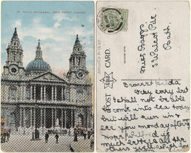
St. Pauls Cathedral, West Front, London
This postcard includes personal correspondence addressed to Miss Baggs of Bath.

This postcard includes personal correspondence addressed to Mr A. E.. Baggs of Kew.
![Misc items - 5 [9 of 16]](/uploads/r/null/3/5/f/35fdaa3e432baeb161083698880d590c614ca481abd2f2426ef287d09f9022d0/12a49660-b424-4602-aefe-cb5bc9fc154c-CVA395-06858_142.jpg)
Part of Habitat Forum photographs
Item is a photograph showing the exterior of the Aberthau Cultural Centre.
![Misc items - 5 [8 of 16]](/uploads/r/null/4/6/4/46410c9fad382c4a9b46e2581eba2aa9167bc661c0e9d3a50ec64e2022a7009a/1ed0f42a-e829-4962-bc7d-f76db10a0f4a-CVA395-06857_142.jpg)
Part of Habitat Forum photographs
Item is a photograph showing the exterior of the Aberthau mansion.

Part of City of Vancouver fonds
Item is a map showing building density by floor space ratio for the downtown area bounded by Burrard Street, Robson Street, and Nicola Street in the west and Main Street in the east.
Part of City of Vancouver fonds
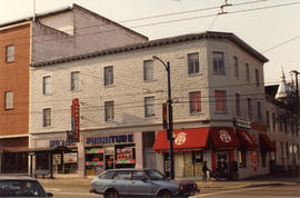
Photograph shows Royal Furniture and Mt. Pleasant Credit Union.

Part of Paul Yee fonds

Part of City of Vancouver Archives technical and cartographic drawing collection
Item is a copy of sections of a November 1889 fire insurance map that have been pieced together. Includes the area between Seymour and Dunlevy Streets, from the south shore of the Burrard Inlet to Keefer Street. Map shows Chinatown, part of False Creek, and buildings and their uses (commercial, residential, industrial). The name of the business, business owner, or type of business is noted for most commercial and industrial buildings.

Construction of Kerrisdale Methodist Church
![[Provincial Day of Action - March for Abortion Rights]](/uploads/r/null/4/e/1/4e1f17674edd94f8f3b31f90f6fd31529cb3fb340d2e4b4ac43249bde2d493fc/36effc43-3cc4-4441-b530-4e8a9d48be9d-CVA1486-32_142.jpg)
[Provincial Day of Action - March for Abortion Rights]
Part of Pro-choice records
Photograph shows the march. Photograph also shows the General Post Office at 349 West Georgia Street.
![[Provincial Day of Action - March for Abortion Rights]](/uploads/r/null/7/0/2/70274f3261ab4b214a863030d7577539e6dda8413e1b0ad8033c899591fc1490/e3511f37-f5ce-4116-a479-a89bfd67663a-CVA1486-33_142.jpg)
[Provincial Day of Action - March for Abortion Rights]
Part of Pro-choice records
Photograph shows the march. Photograph also shows the Hudson's Bay Company building at 674 Granville Street.

Exterior view of Grouse Mountain Chalet

Exterior view of Grouse Mountain Chalet in winter
Photograph shows 2 people standing outside in the snow.

Exterior view of Grouse Mountain Chalet in winter
Photograph shows a person standing outside in the snow.

Interior of Grouse Mountain Chalet
Photograph shows chairs by the fireplace, mantle and stairs.

Interior of Grouse Mountain Chalet
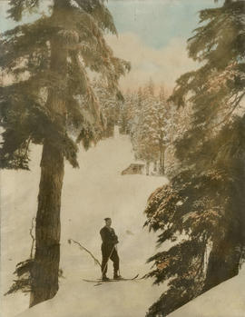
Photograph shows a man on skis.
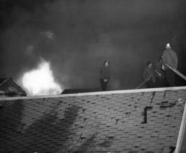
![[View of fire at G.H. Cottrell Warehouse, 139 Water Street]](/uploads/r/null/d/4/2/d42e9cc6d0ed113b820738761abee8e002b3343ece277b2d2aa63d56af341039/38d982ad-3791-47df-aa20-a24e3dff0244-CVA354-018_142.jpg)
[View of fire at G.H. Cottrell Warehouse, 139 Water Street]
Part of City of Vancouver fonds
Item is a photograph showing fire fighters climbing a ladder at building with hoses and engines below and spectators watching from below and from across the street at a rooming house.
![[View of fire at G.H. Cottrell Warehouse, 139 Water Street]](/uploads/r/null/7/7/f/77fd5ca731af55dd5a162210e373ed1c37da355870a390abd03fe0fad87f1f74/0933c3f9-6fcd-4e14-b6fd-5a5b74c03fa0-CVA354-019_142.jpg)
[View of fire at G.H. Cottrell Warehouse, 139 Water Street]
Part of City of Vancouver fonds
Item is a photograph showing the warehouse ablaze and firemen on a ladder. A crowd of spectators is visible in the foreground.
![[Firefighters and motorized equipment in front of Firehall No. 2, 754 Seymour Street]](/uploads/r/null/1/a/2/1a2f1373f1d648856294c4009aca38f93d121927679c379a3ab4dd4db0fd8128/e7169b57-02b8-4cc5-a5d8-122e1c212954-CVA354-043_142.jpg)
[Firefighters and motorized equipment in front of Firehall No. 2, 754 Seymour Street]
Part of City of Vancouver fonds
![[Spectators gathered at apartment fire]](/uploads/r/null/7/e/a/7eaf5dd372b990272c9120815a904008bf9e71ee23108ba12ad938200de8c6cd/4b1985fb-5e6c-4723-ab47-535da5b16817-CVA354-048_142.jpg)
[Spectators gathered at apartment fire]
Part of City of Vancouver fonds
![[Gathering of fire engines to show "Fully Motorized" occasion at C.P.R. freight yards]](/uploads/r/null/4/6/4/464e3333148bebd4439aa317794f2892018b4cdc4c4f2c3e8cfed544422a76d1/ac7aecd4-f952-4786-9697-0f24efacfc7c-CVA354-049_142.jpg)
[Gathering of fire engines to show "Fully Motorized" occasion at C.P.R. freight yards]
Part of City of Vancouver fonds
Item is a photograph showing firefighters and fire equipment with a view of the 700 block of Main Street and a rail car in the background.
![[View of aftermath of fire at Coughlin Shipyards - Fmn. (fireman) Cameron killed]](/uploads/r/null/0/9/4/09432532898fda03f4d03a2915beec43a56c9ffe28f335bee8a3b5e1edfbfa8a/19792784-df36-4eeb-abce-7fa1ec269cb2-CVA354-052_142.jpg)
[View of aftermath of fire at Coughlin Shipyards - Fmn. (fireman) Cameron killed]
Part of City of Vancouver fonds
![[Two members of South Vancouver Fire Department with Studebaker C.S.T. by roadside]](/uploads/r/null/1/3/6/1362dd0e360ddfb8f9c7a69209c447d517c18cc24d756999bbae068498c11e97/f4124cda-9e8c-4cda-abeb-77a5b2aed1df-CVA354-070_142.jpg)
[Two members of South Vancouver Fire Department with Studebaker C.S.T. by roadside]
Part of City of Vancouver fonds

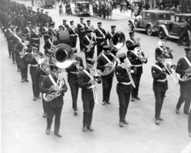
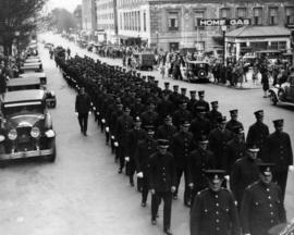
Vancouver Fire Department Band
Part of City of Vancouver fonds
Item is a photograph showing (L-R): Back row - J. Leatherdale, A. LeClair, A.E. Wilkins, L. Leavy, F.G. Luchs, J. Evans, C. Hodson, W. bets, B. Smethurst, R.G. Shaw, G. Harrod, T. Anderson. Middle row - A. King, J. Lyon, T. Warne, C.A. Hillier, A.H. Whipple, H. McElwaine, J. Travis, F. Jenkins, W. Middleton, E. Williamson. Front row - M. Pillat, M. McLeod, E.W. Barnett, G. Ford, M.K. McLennan, H. Ellis, C. Ross.
Part of City of Vancouver fonds

Part of City of Vancouver fonds
Part of City of Vancouver fonds

Part of City of Vancouver fonds
![[View of crowds and fire at Canadian Pacific Railway Pier]](/uploads/r/null/f/c/e/fce743c0128daed19583e4e82a84e7250c4ffcdf765162fe91e58f012f8c647e/6ca98ae0-43f7-410e-945d-da3f3113e69a-CVA354-102_142.jpg)
[View of crowds and fire at Canadian Pacific Railway Pier]
Part of City of Vancouver fonds
![[View of crowds and fire at Canadian Pacific Railway Pier]](/uploads/r/null/2/6/f/26f3a514804e9213c0c6072bbb41069ff8a1aca41deb60e7231722782014fe45/f4952a18-2862-46ac-93bc-a1577784c3e3-CVA354-103_142.jpg)
[View of crowds and fire at Canadian Pacific Railway Pier]
Part of City of Vancouver fonds
![[View of Canadian Pacific Railway Pier D on fire]](/uploads/r/null/9/4/7/947a23d02f7e0b571dc3ea2c42c87f331257cb8e07a77cd2fd080ee000a32c49/43728ece-6a42-442b-8400-3b359d07fb59-CVA354-104_142.jpg)
[View of Canadian Pacific Railway Pier D on fire]
Part of City of Vancouver fonds
![[View from railyard showing the Canadian Pacific Railway Pier D on fire]](/uploads/r/null/9/8/8/98829d8436c7c34cbbc850a4885dbc536b678734e966552bcd71afa7bbb4dfcc/d9de056b-7fa1-4027-985b-46229ce11dc2-CVA354-113_142.jpg)
[View from railyard showing the Canadian Pacific Railway Pier D on fire]
Part of City of Vancouver fonds
![[View of water hoses pouring from Canadian Pacific Station to put out fire at Pier D]](/uploads/r/null/7/9/8/798551f471c491232032352018932010bf28801aaace12720a68ae77015cee00/43c11677-dbe1-47c4-a109-d4b5d811bcf2-CVA354-114_142.jpg)
[View of water hoses pouring from Canadian Pacific Station to put out fire at Pier D]
Part of City of Vancouver fonds
![[View of smoke coming from Canadian Pacific Railway Pier D fire]](/uploads/r/null/8/0/f/80fbdecd3d0dd436ed1a409cbdff968552aab37e875d989befcf4e8652c5832b/521043dc-d66d-42f4-98f0-cbe6e7b33ca6-CVA354-117_142.jpg)
[View of smoke coming from Canadian Pacific Railway Pier D fire]
Part of City of Vancouver fonds

Part of City of Vancouver fonds
![[Firefighters battling fire at Nalos Lumber Company site]](/uploads/r/null/9/a/1/9a14fd68f7e308dbac5768768435b58d0bc4e3e4f6b9ce3f5171e207966646ef/54788840-df5f-470f-a4ed-7ee12c24272b-CVA354-151_142.jpg)
[Firefighters battling fire at Nalos Lumber Company site]
Part of City of Vancouver fonds

Part of City of Vancouver fonds
Part of City of Vancouver fonds

Part of City of Vancouver fonds

Part of City of Vancouver fonds

Part of City of Vancouver fonds