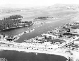
![[View of the harbour from Spencer's Department Store]](/uploads/r/null/2/0/202e8d9d731fb703dfc9c1c09d19f811ee159ca535e8b61865f31dadd624551c/2a899800-eecb-49bd-9760-2d8c09ed120c-A09877_142.jpg)
[View of the harbour from Spencer's Department Store]
- AM54-S4-: Wat N43
- Item
- [193-?]
Part of Major Matthews collection
Photograph shows Canadian Pacific Railway piers 'B' and 'D'.
462 results with digital objects Show results with digital objects
[View of the harbour from Spencer's Department Store]
Part of Major Matthews collection
Photograph shows Canadian Pacific Railway piers 'B' and 'D'.
![[View of the harbour, C.P.R. Pier 'D' and railroad yard from the roof of the Post Office]](/uploads/r/null/0/0/0017cc41004f72fbc45775cf71b997df93d9562b9877c14a78d5a30c67506a85/99ef2020-d62e-4cd3-b0b2-d2a012ec9e1f-A09878_142.jpg)
[View of the harbour, C.P.R. Pier 'D' and railroad yard from the roof of the Post Office]
Part of Major Matthews collection
![[View of the harbour, C.P.R. Pier 'D' and railroad yard from the roof of the Post Office]](/uploads/r/null/e/4/e403caef05acedfc9e78203f7cac185e22853ec36a357deb2f1e3cbb517c0f44/0ce56549-03f9-4349-9a5e-267ba26928df-A09879_142.jpg)
[View of the harbour, C.P.R. Pier 'D' and railroad yard from the roof of the Post Office]
Part of Major Matthews collection
Part of Major Matthews collection
Oblique view looking northeast showing the Denman Arena, the Georgia Street entrance to Stanley Park, the Vancouver Rowing Club, Brockton Point and Deadmans Island
Privy Council (Canada) collection
Item is an extract of a report of a Committee of the Privy Council, dated 8 July 1893, regarding foreshore rights in Vancouver of the Canadian Pacific Railway Company, with two accompanying maps. One map is in the file; the other one is catalogued as Map 648.
Along the no. 20 line : reminiscences of the Vancouver waterfront.
Proceedings of the annual convention.
Canada's Pacific gateways : realizing the vision.
Port of Vancouver. Annual report.
Fraser port : freightway to the Pacific, 1858-1985
The Port of Vancouver : Canada's global gateway
Frank Waterhouse & Company's Pacific Ports
Part of Major Matthews collection
Vancouver Harbour [sectional map]
Part of City of Vancouver Archives technical and cartographic drawing collection
File contains 42 maps showing soundings, harbour headlines, high water marks, shore lines, shoals, submarine cable, rail lines and trails in the Vancouver area. Maps also show names of businesses and other structures.
C.H. Bailey's Table of distances from port to port.