
- AM54-S4-: SGN 901
- Item
- [1896?]
Part of Major Matthews collection
J.S. Matthews' notes with print or negative in Archives.
462 results with digital objects Show results with digital objects
Part of Major Matthews collection
J.S. Matthews' notes with print or negative in Archives.

Part of Major Matthews collection
J.S. Matthews' notes with print or negative in Archives.
![[View of Coal Harbour, Deadmans Island, and North Shore mountains from foot of Thurlow Street]](/uploads/r/null/4/c/4ce8248f3e2c6a40b98fe6815778e930d730e9bc6fef96c61b3f9f0715075431/ed4d630a-fcce-461f-aaaa-3bab818f9bc6-A07647_142.jpg)
[View of Coal Harbour, Deadmans Island, and North Shore mountains from foot of Thurlow Street]
Part of Major Matthews collection
J.S. Matthews' notes with print or negative in Archives.
![[View of ship in Coal Harbour and Deadman's Island, from foot of Bute Street]](/uploads/r/null/c/a/ca08065478426138b96322562f2e229721e66f75053f6ef16a6f73c655815bf9/e78cbbbf-fc54-4725-a7a8-7bbee9ee0162-A07648_142.jpg)
[View of ship in Coal Harbour and Deadman's Island, from foot of Bute Street]
Part of Major Matthews collection
J.S. Matthews' notes with print or negative in Archives.
![[View of water front showing the C.P.R. station and yard and Pier D under construction]](/uploads/r/null/2/7/2781b7cdfb12c9119a5fca39a4be76488e2a9adc05038f861af4810c250356bf/2ca5a454-46e7-41c1-84fb-580e4bc03252-A63185_142.jpg)
[View of water front showing the C.P.R. station and yard and Pier D under construction]
Part of Major Matthews collection
![[Northern view of downtown Vancouver from World Building, 500 Beatty Street]](/uploads/r/null/9/9/997cc0ffa3d5b19d17a58c9f16a1c6f9855c9019e5f3249c78d456803ea58779/b52f219d-f015-40b1-96a6-c089ab3c8d70-A63175_142.jpg)
[Northern view of downtown Vancouver from World Building, 500 Beatty Street]
Part of Major Matthews collection
Photograph also shows Central Public School, Victory Square, Vancouver Daily Province and Dominion Bank Buildings, the Flack Block and C.P.R. Piers B and C and the North Shore in the background.

Part of Major Matthews collection
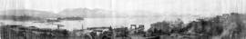
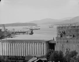
Panoramic view showing Burrard Inlet including 42 ocean steamers in port of which 25 were for grain cargoes, 17 vessels at berth (not shown in photograph) and the Harbour Commissioners wharf and Grain Elevator No. 1 and log booms

Panoramic view showing Burrard Inlet including 42 ocean steamers in port of which 25 were for grain cargoes, 17 vessels at berth (not shown in photograph) and the Harbour Commissioners wharf and Grain Elevator No. 1 and log booms
![[View of Burrard Inlet toward Howe Sound from Point Grey]](/uploads/r/null/d/7/d70841724af53c279a31c140bbc1fce42a0aa6a1d3a9c40cff087f263ccc345d/7095bde6-1c57-4e91-b87a-60bb6b7cd9f3-A64735_142.jpg)
[View of Burrard Inlet toward Howe Sound from Point Grey]
Part of Major Matthews collection
![[View of Burrard Inlet from Point Grey]](/uploads/r/null/e/3/e320d8072b352225b343a6bf036a24dfbe3d1f2d722001dd0b12d0aa899d36bb/bb12fe87-3475-4839-9e59-891393008d05-A64782_142.jpg)
[View of Burrard Inlet from Point Grey]
Part of Major Matthews collection
Panoramic view showing a pier and Stanley Park in background.
Part of John William Freeston fonds
Panoramic view showing fuel oil tanks at the foot of Bute Street, Coal Harbour, the Vancouver Rowing Club, Deadmans Island, Brockton Point, the C.P.R. freight car ferry dock, the Immigration building, C.P.R. Pier A and Pender Street west of Burrard Street
![[Northeast view of downtown Vancouver from the roof of the Hotel Vancouver]](/uploads/r/null/d/e/de95d099d1517793665187336820ebdb65db9f066b651b935a78788383053fb3/5b49058f-4381-43c8-b28f-9755248fa953-A63006_142.jpg)
[Northeast view of downtown Vancouver from the roof of the Hotel Vancouver]
Part of Major Matthews collection
Panoramic view showing Coal Harbour, Deadman's Island, Burrard Inlet, the S.S. "Charmer", the Winch Building under construction, the Bank of Montreal and the Hudson's Bay Co. buildings.

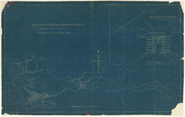
Coal Harbor Vancouver. Height of Water In Upper End 9 ft. above. Zero
Part of Major Matthews collection
Panoramic view showing Lost Lagoon, the Stanley Park Causeway under construction and the Vancouver Rowing Club.
![[360 degree view of Vancouver from the roof of the second Hotel Vancouver]](/uploads/r/null/7/2/72f205b48502a927912ec46b74aa571f102f387013c2d6bce557a2420fd72aa7/269934f7-d517-4c58-b633-4167772f935b-A63168_142.jpg)
[360 degree view of Vancouver from the roof of the second Hotel Vancouver]
Part of Major Matthews collection
Photograph shows many downtown streets and buildings including the Vancouver Block, Wesley Methodist Church, Christ Church, the World Building as well as Coal Harbour, Burrard Inlet and the North Shore in the background.

First Narrows, Burrard Inlet, B.C. showing Parthia and Burnaby shoals
Part of City of Vancouver Archives technical and cartographic drawing collection
Item is a map showing shorelines, estuaries of adjacent creeks, mud flats, tide levels and soundings in feet. Map notes velocity of current at First Narrows.
New Westminster (B.C.). Department of Public Works

Part of City of Vancouver Archives technical and cartographic drawing collection
Item contains both nautical chart and map data. Nautical chart data includes soundings, anchorages, ferry lines, wharves, and waterfront businesses. Map features include district lots, streets, railways, and municipal boundaries.

False Creek interim harbour headline
Part of City of Vancouver Archives technical and cartographic drawing collection
Map shows interim and ultimate headline, interim headline, ultimate headline, and existing headline, as well as streets, lots, railway yards and waterfront industries in the False Creek area. Map was created for the "False Creek development" study, "Harbour headline" project.
![Burrard Viaduct Construction [1 of 10]](/uploads/r/null/2/7/2788a9638050d7cbfc021e29977d956f423fe6048bb7c29c035ea57bda6dd66c/5df17b4f-3ebf-4f8d-ac21-de11bd89033f-A66652_142.jpg)
Burrard Viaduct Construction [1 of 10]
Part of City of Vancouver fonds
Building of Burrard Viaduct with Coal Harbour in the background, including part of Deadman's Island and a floating fuel station on the left and the mountains beyond.
![Burrard Viaduct Construction [2 of 10]](/uploads/r/null/5/7/57426101abc66a2ab407c951565e28bb07f8f27238a35bb05d7478ded4e540b1/8b87415b-c4bc-4c5c-bf5c-89e3546722c2-A66653_142.jpg)
Burrard Viaduct Construction [2 of 10]
Part of City of Vancouver fonds
Building of Burrard Viaduct with Coal Harbour in the background, including part of Deadman's Island and a floating fuel station on the left and the mountains beyond.
Part of Harold D. Kalman fonds
Part of Harold D. Kalman fonds
Part of Harold D. Kalman fonds
Item is a drawing of a harbour that may be Coal Harbour.

Part of City of Vancouver fonds
Item shows Point Grey harbour facilities and industrial lands, the Jericho naval reserve and golf links through a combination of a map and illustrations. A smaller key plan shows the location of the Vancouver Terminals Company's harbour properties in relation to the rest of Point Grey and Vancouver.
![Indian dugout canoe on Burrard Inlet [harbour]](/uploads/r/null/2/5/a/25af1ea9a08cd9f6c1484d7caea4c657ce39d9f11c8bf817638c408febc6624e/1b7ab234-6ea1-4411-8c92-459e46c6471f-CVA99-2122_142.jpg)
Indian dugout canoe on Burrard Inlet [harbour]
Part of Stuart Thomson fonds

Pleasure craft "Nancy Anne" in Vancouver harbour
Part of Stuart Thomson fonds
Part of Stuart Thomson fonds

Visit of H.M.S Durbain, Despatch, and H.M.C.S Vancouver
Part of Stuart Thomson fonds
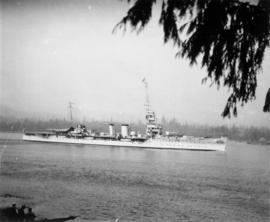
Ship - possibly H.M.S. Despatch
Part of Stuart Thomson fonds
Suggested harbour improvements Burrard Inlet
Part of City of Vancouver fonds

This postcard includes personal correspondence addressed to Maurice Baggs of Vancouver.

The Harbour Mouth from Common, Looe
This postcard includes personal correspondence addressed to Edwin Baggs of Vancouver.

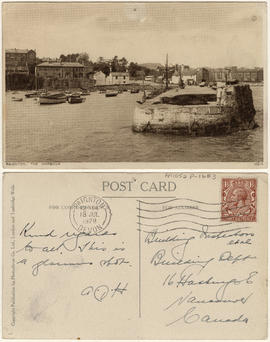
This postcard includes personal correspondence addressed to Building Inspectors, Building Dept. of Vancouver.

This postcard includes personal correspondence addressed to Mr. Arthur Baggs of Bath.

Part of Major Matthews collection
Item is a photograph of a painting of the scene depicted in the image with the identifier SGN 155.

Rail journey through the Rocky Mountains, Victoria, and dog show
Part of Samuel S. Magoffin fonds
Item is an amateur film opening with footage of downtown Vancouver showing several Vancouver Fire Department trucks and engines and a lot filled with lumber, then cutting to footage taken from the back of a moving train, showing snow covered scenery, followed by Sam and Margaret Magoffin standing on a porch with several other people and a dog, Margaret and a man standing in front of a car, and additional footage taken from a moving train showing a sign for Yoho, mountain scenery and the Cathedral train station. The film also contains footage taken in downtown Victoria, B.C. showing the legislative building, Inner Harbour and CPR Steamship Terminal building, followed by dogs, likely the Magoffin’s golden retrievers, and several minutes footage of a dog show.
Vancouver Harbour [sectional map]
Part of City of Vancouver Archives technical and cartographic drawing collection
File contains 42 maps showing soundings, harbour headlines, high water marks, shore lines, shoals, submarine cable, rail lines and trails in the Vancouver area. Maps also show names of businesses and other structures.
Vancouver Harbour : plan of south shore, Burrard Inlet between Heatley Ave. and Victoria Dr.
Part of City of Vancouver Archives technical and cartographic drawing collection
Item is a map which shows parcels of land along Burrard Inlet and district lots in downtown Vancouver. Piers, factories and mills along the waterfront are identified. Soundings are shown in feet.
National Harbours Board
Plan of False Creek, Vancouver, B.C.
Part of City of Vancouver Archives technical and cartographic drawing collection
Map shows streets, railways, land to be reclaimed, foreshore applied for, foreshore granted by order in council, proposed wharf lines, areas to be dredged and land ownership in and along False Creek. A key map in the top right-hand corner shows the location of False Creek in relation to the rest of Vancouver.
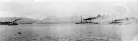
Japanese Warships on visit to Vancouver B.C. Feb. 6-12/1925
Part of Major Matthews collection
Panoramic view showing Coal Harbour, the North Shore Mountains and three warships identified as Asama, Idzumo and Yakumo

Part of Major Matthews collection
Photograph shows Lions Gate Bridge, Beaver Lake, Lost Lagoon, Prospect Point, Brockton Point, Deadman's Island, Royal Vancouver Yacht Club, H.M.C.S. Discovery, Brockton Oval and English Bay.

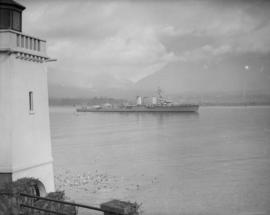
H.M.S. Bonaventure in Vancouver Harbour, B.C.

Prince Rupert : misc. pix : Jack Long
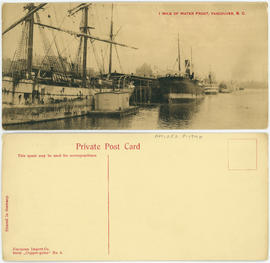
1 mile of water front, Vancouver, B.C.

Victoria Harbour from C.P.R. Hotel, Victoria, B.C.
Item is a postcard showing the Victoria Harbour. The back of the postcard includes personal correspondence addressed to Miss Buhman.

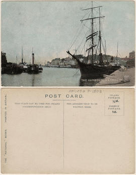
No. 1053, Burrard Inlet, Vancouver, B.C.
Item is a postcard showing the Burrard Inlet. The back of the postcard includes personal correspondence.

Vancouver Water Front, Vancouver, B.C. (Canada)
Item is a postcard showing Coal Harbour. Caption on back of photograph: "View taken from Stanley Park showing Coal Harbour. In the foreground are boats belonging to the Burrard Yacht Club. In the background can be seen the Marine Building, the tallest in Vancouver, and part of the skyline." The back of the postcard includes personal correspondence addressed to Mr. and Mrs. C.W. McClain.

Deadman's Island and Inlet, Vancouver, B.C.
Harbour and bridge from Capitol Hill