
Stanley Park, fountain in duck pond
- AM1376-: CVA 72-47
- Item
- [between 1950 and 1952]
Stanley Park, fountain in duck pond
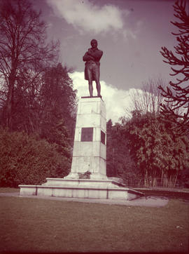
Robbie Burns statue, Stanley Park; Vancouver, Mar 18/50
Item is a photograph of the Robert Burns Memorial in Stanley Park.

Stanley Park, Shakespeare Memorial
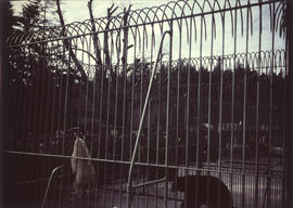
Stanley Park, bear cage with two polar bears and two grizzly bears
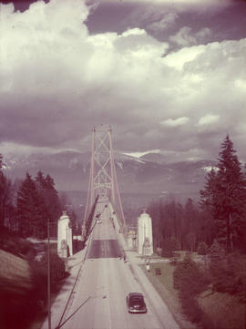
Stanley Park, Lions Gate Bridge southern approach
Item is a photograph of the southern approach to the Lion's Gate Bridge from Stanley Park. Looking north across the bridge, the road, decorative lions and pylons, and cables and piers are visible.

Japanese cherry trees, Stanley Park; 1950
Item is a photograph of Japanese cherry trees in bloom around the Japanese Memorial in Stanley Park.
![Wilson [Harding] memorial, Stanley Park](/uploads/r/null/6/8/e/68e3a71452408ba9791fc140e1befcb53d79722b0251cbd86632949a37835c0c/77c422b7-125a-44e2-8a8b-9850a21f7699-CVA72-53_142.jpg)
Wilson [Harding] memorial, Stanley Park
Item is a photograph of the Warren G. Harding Memorial in Stanley Park.

Part of City of Vancouver Archives technical and cartographic drawing collection
Item is a copy of a map of Vancouver which has been hand annotated. The annotations appear to relate to proposed revisions to the street network, including major streets to be widened and new major street connections.
Vancouver (B.C.). Engineer's Office

Samuel Garvin Prop. & staff of pure Milk Dairy Co. Vancouver. B.C. June 15.1916
Part of Major Matthews collection
Photograph shows S. Garvin and other in an automobile among hore-drawn milk wagons and delivery men in front of the bandstand in Robson Park. Photograph also shows houses in the 500 block 13th Ave E, the 2900 block Carolina Street and 600 block 14th Ave E.

Sheet W : Fraser River to French Street and Fifty-ninth Avenue to Seventy-first Avenue
Part of City of Vancouver Archives technical and cartographic drawing collection
Item is a section showing the area from the Fraser River to French Street and Fifty-ninth Avenue to Seventy-first Avenue. Includes streets, roads, blocks, lots, legal descriptions, parks and golf courses.
Vancouver (B.C.). Office of the City Engineer

Sheet L : Trafalgar Street to Granville Street and Nanton Avenue to Thirty-eighth Avenue
Part of City of Vancouver fonds
Item is a section showing the area from Trafalgar Street to Granville Street and Nanton Avenue to Thirty-eighth Avenue. Includes streets, roads and sewers; blocks, lots and legal descriptions; and parks, golf courses and schools. The map is hand coloured to show tax sale property for sale, property with no water, street widening and drainage, replotting, reserved land for schools, reserved land for parks, sundry land, capital assets not including schools and parks, schools, and parks, as applicable.
Vancouver (B.C.). Office of the City Engineer

Sheet M : Granville Street to Kersland Drive and Twenty-seventh Avenue to Thirty-eighth Avenue
Part of City of Vancouver fonds
Item is a section showing the area from Granville Street to Kersland Drive and Twenty-seventh Avenue to Thirty-eighth Avenue. Includes streets and roads; blocks, lots and legal descriptions; and golf courses, parks and government buildings. The map is hand coloured to show tax sale property for sale, property with no water, street widening and drainage, replotting, reserved land for schools, reserved land for parks, sundry land, capital assets not including schools and parks, schools, and parks, as applicable.

Gov. General Bessborough inspecting Boy Scouts at Ceperley Playground
Part of Stuart Thomson fonds
![[Composite of three Vancouver scenes]](/uploads/r/null/6/3/63a212dcbeefd621100706d8f124b87a33a6c9b89b843c22e400d20998580f4b/0a7256b5-202a-467c-a84e-a7798851caef-A03937_142.jpg)
[Composite of three Vancouver scenes]
Part of Major Matthews collection
Photograph consists of a composite of three photographs, showing a salmon cannery, Brockton Point, and a view of Vancouver from Mount Pleasant. The images were photographed while mounted on a sheet of newspaper.
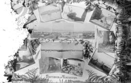
Part of Major Matthews collection
Photograph consists of various images of Vancouver, including sites in Stanley Park, boats, street scenes, a cannery, and other photographs, surrounded by foliage and fruit.
![[Boats in Burrard Inlet, near Brockton Point]](/uploads/r/null/f/6/f6ab148af8419f2d34b065e701dc36facfcd9b0b2f4acfec988fe9275d477ff2/11448caf-652a-43d9-9ef9-f91b97e4aaab-A04013_142.jpg)
[Boats in Burrard Inlet, near Brockton Point]
Part of Major Matthews collection
J.S. Matthews' notes with print or negative in Archives.

Rockeries at Queen's Park, Mr. Rigby
Part of Stuart Thomson fonds

General development plan, Exhibition Park, Vancouver, B.C.
Part of City of Vancouver Archives technical and cartographic drawing collection
Item is a map showing the Exhibition Park site, with existing buildings, proposed buildings (immediate program), proposed buildings (future program), building names and parking lot capacities.
Harland Bartholomew and Associates

Park Tour - Rathie Cuts Ribbon
Part of William Orson Banfield fonds

Part of Elizabeth Walker fonds
Item is a photograph showing the view from 4875 Valley Drive. Written on slide: "Quilchena Drive and up the slope!"

Part of Elizabeth Walker fonds
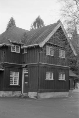
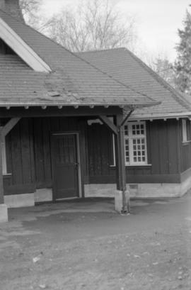
Item is a photograph showing buildings in Jericho Park, now hostel buildings at 1515 Discovery Street.

Part of Elizabeth Walker fonds
Item is a photograph showing former Jericho Air Base buildings on Discovery Street.

Part of Elizabeth Walker fonds

Part of Elizabeth Walker fonds
Item is a photograph showing former Jericho Air Base buildings on Discovery Street.

Soccer - Scottish Football Team and All Stars at Con Jones Park
Part of Stuart Thomson fonds
![Chambers Family - Group [portrait in Clark park]](/uploads/r/null/1/1/118b69452b8ab91b683435805106082dbaf890e7a2e7b6a6ebbe18623e9dccdf/d3df08b3-a337-4762-ae6d-120ea294fa71-A17124_142.jpg)
Chambers Family - Group [portrait in Clark park]
Part of Stuart Thomson fonds
Individuals identified in the photograph are:
Front row (L-R): George Rhodes Chambers, Rupert Rhodes Chambers and Bessie Henrietta Chambers
Back row (L-R): Pearl Elva Chambers, Claude Rhodes Chambers, Bernard Rhodes Chambers and Muriel Mary Chambers
![Chambers Family - Group [portrait in Clark Park]](/uploads/r/null/0/3/0324af74bf7073516b0fca5e235edec6c5a8dbf67f93a037d6b98018e56b5063/acc1b80d-d53a-4d46-b436-f91107e7616a-A17123_142.jpg)
Chambers Family - Group [portrait in Clark Park]
Part of Stuart Thomson fonds
Individuals identified in the photograph are:
Front row (L-R): Muriel Mary Chambers, George Rhodes Chambers, Bessie Henrietta Chambers and Pearl Elva Chambers
Back row (L-R): Claude Rhodes Chambers, Rupert Rhodes Chambers and Bernard Rhodes Chambers
![[Composite view of ships and Stanley Park sites]](/uploads/r/null/3/c/3c46b96242786e4b1aad8df2b667da89143a46e55dc4a60c9541d68888ae6ac9/d6361a9b-8768-494b-911e-6f055c94677c-A03966_142.jpg)
[Composite view of ships and Stanley Park sites]
Part of Major Matthews collection
Photograph consists of a composite of four photographs showing: large tree in Stanley Park, bridge in Stanley Park, the S.S. "Beaver" on shore (Bo P124), and the "Empress of India" at Vancouver dock (Bo P 6.4).

Looking over Brockton Point in Stanley Park, from C.P.R. Hotel Vancouver, B.C.
Part of William Orson Banfield fonds

Sheet W : Fraser River to French Street and Fifty-ninth Avenue to Seventy-first Avenue
Part of City of Vancouver fonds
Item is a section showing the area from Fraser River to French Street and Fifty-ninth Avenue to Seventy-first Avenue. Includes streets and roads; blocks, lots and legal descriptions; and parks and golf courses. Map is hand coloured to show tax sale property for sale, property with no water, street widening and drainage, replotting, reserved land for schools, reserved land for parks, sundry land, capital assets not including schools and parks, schools, and parks, as applicable.
Vancouver (B.C.). Office of the City Engineer

Sheet X : Marine Drive to Ash Street and Fifty-ninth Avenue to Seventy-first Avenue
Part of City of Vancouver fonds
Item is a section showing the area from Marine Drive to Ash Street and Fifty-ninth Avenue to Seventy-first Avenue. Includes streets and roads; blocks, lots and legal descriptions; and parks and schools. Map is hand coloured to show tax sale property for sale, property with no water, street widening and drainage, replotting, reserved land for schools, reserved land for parks, sundry land, capital assets not including schools and parks, schools, and parks, as applicable.

Sheet 1 : Cambie Street to Carolina Street and Sixteenth Avenue to Twenty-eighth Avenue
Part of City of Vancouver fonds
Item is a section showing the area from Cambie Street to Carolina Street and Sixteenth Avenue to Twenty-eighth Avenue. Includes streets, roads, blocks, lots, legal descriptions, parks, nurseries and schools. Map is hand coloured to show tax sale property for sale, property with no water, street widening and drainage, replotting, reserved land for schools, reserved land for parks, sundry land, capital assets not including schools and parks, schools, and parks, as applicable.
Vancouver (B.C.). Office of the City Engineer

Sheet 3 : Cambie Street to St. George Street and Twenty-seventh Avenue to Thirty-eighth Avenue
Part of City of Vancouver fonds
Item is a section showing the area from Cambie Street to St. George Street and Twenty-seventh Avenue to Thirty-eighth Avenue. Map shows streets, roads, blocks, lots and legal descriptions and the locations of parks, schools, reservoirs and Mountainview Cemetery. Map is hand coloured to show tax sale property for sale, property with no water, street widening and drainage, replotting, reserved land for schools, reserved land for parks, sundry land, capital assets not including schools and parks, schools, and parks, as applicable.
Vancouver (B.C.). Office of the City Engineer

Sheet 4 : Prince Edward Street to Bruce Street and King Edward Avenue to Thirty-sixth Avenue
Part of City of Vancouver fonds
Item is a section showing the area from Prince Edward Street to Bruce Street and King Edward Avenue to Thirty-sixth Avenue. Map shows streets, roads, blocks, lots and legal descriptions, and the locations of parks, schools and Mountainview Cemetery. Map is hand coloured to show tax sale property for sale, property with no water, street widening and drainage, replotting, reserved land for schools, reserved land for parks, sundry land, capital assets not including schools and parks, schools, and parks, as applicable.
Vancouver (B.C.). Office of the City Engineer

Sheet 5 : Dumfries Street to Fairmont Street and Twenty-seventh Avenue to Thirty-seventh Avenue
Part of City of Vancouver fonds
Item is a section showing the area from Dumfries Street to Fairmont Street and Twenty-seventh Avenue to Thirty-seventh Avenue. Includes streets, roads, blocks, lots, legal descriptions, parks, railway lines and schools. Map is hand coloured to show tax sale property for sale, property with no water, street widening and drainage, replotting, reserved land for schools, reserved land for parks, sundry land, capital assets not including schools and parks, schools, and parks, as applicable.
Vancouver (B.C.). Office of the City Engineer

Sheet 6 : Craddock Street to Boundary Road and Twenty-ninth Avenue to Fortieth Avenue
Part of City of Vancouver fonds
Item is a section showing the area from Craddock Street to Boundary Road and Twenty-ninth Avenue to Fortieth Avenue. Includes streets, roads, blocks, lots, legal descriptions, parks. railway lines and schools. Map is hand coloured to show tax sale property for sale, property with no water, street widening and drainage, replotting, reserved land for schools, reserved land for parks, sundry land, capital assets not including schools and parks, schools, and parks, as applicable.
Vancouver (B.C.). Office of the City Engineer

Sheet 7 : Cambie Street to St. George Street and Thirty-seventh Avenue to Forty-eighth Avenue
Part of City of Vancouver fonds
Item is a section showing the area from Cambie Street to St. George Street and Thirty-seventh Avenue to Forty-eighth Avenue. Includes streets, roads, blocks, lots, legal descriptions, parks, cemeteries, and schools. Map is hand coloured to show tax sale property for sale, property with no water, street widening and drainage, replotting, reserved land for schools, reserved land for parks, sundry land, capital assets not including schools and parks, schools, and parks, as applicable.
Vancouver (B.C.). Office of the City Engineer

Sheet 8 : Prince Edward Street to Bruce Street and Thirty-fifth Avenue to Forty-seventh Avenue
Part of City of Vancouver fonds
Item is a section showing the area from Prince Edward Street to Bruce Street and Thirty-fifth Avenue to Forty-seventh Avenue. Includes streets, roads, blocks, lots, legal descriptions, and cemeteries, parks and schools. Map is hand coloured to show tax sale property for sale, property with no water, street widening and drainage, replotting, reserved land for schools, reserved land for parks, sundry land, capital assets not including schools and parks, schools, and parks, as applicable.
Vancouver (B.C.). Office of the City Engineer

Sheet 9 : Fleming Street to Carlton Street and Thirty-seventh Avenue to Forty-eighth Avenue
Part of City of Vancouver fonds
Item is a section showing the area from Fleming Street to Carlton Street and Thirty-seventh Avenue to Forty-eighth Avenue. Includes streets, roads, blocks, lots, legal descriptions, parks and schools. Map is hand coloured to show tax sale property for sale, property with no water, street widening and drainage, replotting, reserved land for schools, reserved land for parks, sundry land, capital assets not including schools and parks, schools, and parks, as applicable.
Vancouver (B.C.). Office of the City Engineer

Sheet 10 : Earles Street to Boundary Road and Fortieth Avenue to Fiftieth Avenue
Part of City of Vancouver fonds
Item is a section showing the area from Carlton Street to Boundary Road and Fortieth Avenue to Fiftieth Avenue. Includes streets, roads, blocks, lots, legal descriptions, parks and schools. Map is hand coloured to show tax sale property for sale, property with no water, street widening and drainage, replotting, reserved land for schools, reserved land for parks, sundry land, capital assets not including schools and parks, schools, and parks, as applicable.
Vancouver (B.C.). Office of the City Engineer

Sheet 11 : Cambie Street to St. George Street and Forty-seventh Avenue to Fifty-eighth Avenue
Part of City of Vancouver fonds
Item is a section showing the area from Cambie Street to St. George Street and Forty-seventh Avenue to Fifty-eighth Avenue. Includes streets, roads, blocks, lots, legal descriptions, golf courses, parks and schools. Map is hand coloured to show tax sale property for sale, property with no water, street widening and drainage, replotting, reserved land for schools, reserved land for parks, sundry land, capital assets not including schools and parks, schools, and parks, as applicable.
Vancouver (B.C.). Office of the City Engineer

Sheet 12 : Prince Edward Street to Bruce Street and Forty-seventh Avenue to Fifty-eighth Avenue
Part of City of Vancouver fonds
Item is a section showing the area from Prince Edward Street to Bruce Street and Forty-seventh Avenue to Fifty-eighth Avenue. Includes streets, roads, blocks, lots, legal descriptions, parks and schools. Map is hand coloured to show tax sale property for sale, property with no water, street widening and drainage, replotting, reserved land for schools, reserved land for parks, sundry land, capital assets not including schools and parks, schools, and parks, as applicable.
Vancouver (B.C.). Office of the City Engineer

Sheet 13 : Fleming Street to Carlton Street and Forty-seventh Avenue to Fifty-ninth Avenue
Part of City of Vancouver fonds
Item is a section showing the area from Fleming Street to Carlton Street and Forty-seventh Avenue to Fifty-ninth Avenue. Includes streets, roads, blocks, lots, legal descriptions, parks and schools. Map is hand coloured to show tax sale property for sale, property with no water, street widening and drainage, replotting, reserved land for schools, reserved land for parks, sundry land, capital assets not including schools and parks, schools, and parks, as applicable.
Vancouver (B.C.). Office of the City Engineer

Sheet 14 : Ash Street to St. George Street and Marine Drive to Fraser River
Part of City of Vancouver fonds
Item is a section showing the area from Ash Street to St. George Street and Marine Drive to Fraser River. Includes streets, roads, blocks, lots, legal descriptions, parks and railway lines. Map is hand coloured to show tax sale property for sale, property with no water, street widening and drainage, replotting, reserved land for schools, reserved land for parks, sundry land, capital assets not including schools and parks, schools, and parks, as applicable.
Vancouver (B.C.). Office of the City Engineer

Sheet 15 : Ash Street to St. George Street and Fifty-eighth Avenue to Marine Drive
Part of City of Vancouver fonds
Item is a section showing the area from Ash Street to St. George Street and Fifty-eighth Avenue to Marine Drive.Includes streets, roads, blocks, lots, legal descriptions, parks and railway lines. Map is hand coloured to show tax sale property for sale, property with no water, street widening and drainage, replotting, reserved land for schools, reserved land for parks, sundry land, capital assets not including schools and parks, schools, and parks, as applicable. A note in ink at the top of the map indicates that "Brown-green refers to the Crippled Childrens Hospital Reserve."
Vancouver (B.C.). Office of the City Engineer

Sheet 16 : St. George Street to Argyle Street and Fifty-eighth Avenue to Fraser River
Part of City of Vancouver fonds
Item is a section showing the area from St. George Street to Argyle Street and Fifty-eighth Avenue to the Fraser River. Includes streets, roads, blocks, lots, legal descriptions, railway lines, parks and schools. Map is hand coloured to show tax sale property for sale, property with no water, street widening and drainage, replotting, reserved land for schools, reserved land for parks, sundry land, capital assets not including schools and parks, schools, and parks, as applicable.
Vancouver (B.C.). Office of the City Engineer

Sheet 17 : Argyle Street to Vivian Street and Sixty-second Avenue to Kent Street
Part of City of Vancouver fonds
Item is a section showing the area from Argyle Street to Vivian Street and Sixty-second Avenue to Kent Street. Includes streets, roads, blocks, lots, legal descriptions and golf courses. Map is hand coloured to show tax sale property for sale, property with no water, street widening and drainage, replotting, reserved land for schools, reserved land for parks, sundry land, capital assets not including schools and parks, schools, and parks, as applicable. "22, 23, 25 to 33, 35, 36/258-329" is written in ink at the top of the map.
Vancouver (B.C.). Office of the City Engineer
Part of City of Vancouver fonds
Part of City of Vancouver fonds

Part of City of Vancouver fonds