
Plan of subdivision of part of D.L. 526 : South Vancouver

Plan of subdivision of part of D.L. 526, New Westminster District, B.C., Kitsilano, City of Vancouver

Plan of survey of coast-line around Coal Peninsula, New Westminster District
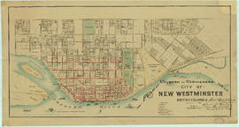
Plan of system of sewerage for the city of New Westminster, British Columbia

Plan of the Burrard Inlet and Pitt River canal location

Plan of the City of Vancouver

Plan of the City of Vancouver

Plan of the City of Vancouver

Plan of the City of Vancouver. Western Terminus of the Canadian Pacific Railway

Plan of the City of Vancouver, B.C.

Plan of the City of Vancouver, B.C.

Plan of the City of Vancouver, British Columbia

Plan of the City of Vancouver, British Columbia

Plan of the Kaminstiquia River and Plan showing survey and soundings of Lake Ellen and Nipigon Bay

Plan of the municipality of South Vancouver

Plan of the town of Newcastle, English Bay

Plan of the Town of Port-Moody, British Columbia

Plan of the townsite of North Vancouver

Plan of the Vancouver Exhibition grounds
![Plan of town of Lonsdale : situate [sic] on harbour opposite City of Vancouver](/uploads/r/null/c/5/d/c5d4b56db1d7f9e1cf57dd5a974f6fcb23507e64543bad1bdd8f62139042389f/1cc57eaf-6c92-438e-a65d-335940738df7-MAP686_142.jpg)
Plan of town of Lonsdale : situate [sic] on harbour opposite City of Vancouver

Plan of townsite at Eburne

Plan of Vancouver Harbour and False Creek, Vancouver, B.C., showing proposed improvements as outlined in Jos. R. Roy's reports dated 15th Sept. 1906

Plan of West Vancouver Municipality
![Plan shewing [showing] division of property belonging to Major C.W. Hill](/uploads/r/null/0/f/0f72067c788c91a520f5055e8b1241e0ee99f2c20c434b03eca0174baea425dc/d22e8a25-814f-4266-99a4-24c639764600-MAP787_142.jpg)
Plan shewing [showing] division of property belonging to Major C.W. Hill
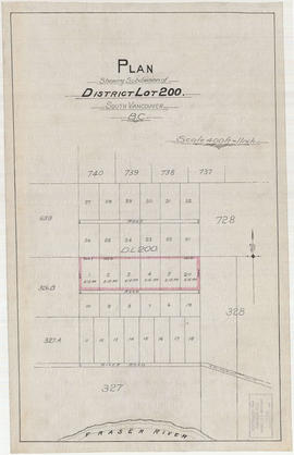
Plan shewing subdivision of District Lot 200. South Vancouver, B.C.

Plan showing bus routes and stops in the downtown area, Vancouver, B.C., October 1961

Plan showing lands occupied in Stanley Park near Brockton Point. City of Vancouver B.C.

Plan showing lands occupied in Stanley Park near Brockton Point, City of Vancouver, B.C.

Plan showing locations of oil and gas seepages and oil wells in Fraser Valley, British Columbia
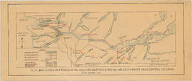
Plan showing locations of oil and gas seepages and oil wells in Fraser Valley, British Columbia

Plan showing polling divisions, City of Vancouver B.C., as defined in by-law no. 2434

Plan showing polling divisions, City of Vancouver, B.C.

Plan showing Vancouver's grave and surrounding graves at Church

Plan showing vicinity of Fisher Case, Nov 9th, 1949
![Plan to accompany by-law no. [Blank] being a by-law to amend by-law no. 4054 being the street nam...](/uploads/r/null/3/a/d/3ad2e1a740be487ac9cdd1a7e10ac6cbe15cda433b0937bde9a0837696e4148a/802101ef-808b-4353-a5fe-3100da56eeb7-MAP71c_142.jpg)
Plan to accompany by-law no. [Blank] being a by-law to amend by-law no. 4054 being the street naming by-law
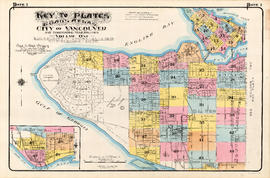
Plate 1: Key to Plates. Goad's Atlas. City of Vancouver and Surrounding Municipalities. Volume One
![Plate 10 [CPR yards between Pender Street and Georgia viaduct]](/uploads/r/null/4/d/f/4df4324d57fa032950845b1be5ae2e04c2707c20e598bf307101a36ba7929130/176fae2d-a49c-4f75-99db-5ec876a739ce-1972-582_142.jpg)
Plate 10 [CPR yards between Pender Street and Georgia viaduct]
![Plate 10: West End [Thurlow Street - Nelson Street - Cardero Street - Burnaby Street]](/uploads/r/null/e/b/2/eb281da970ebd644483c0c62bac6df4efa77211537470a4acc06ddf0dfdfca64/aee7ff8d-629b-4876-aa73-91222025ab9b-MAP342a_142.jpg)
Plate 10: West End [Thurlow Street - Nelson Street - Cardero Street - Burnaby Street]

Plate 100: Renfrew-Collingwood [Rupert Street - Thirty-fifth Avenue - Victoria Drive - Forty-sixth Avenue]
![Plate 101 [Alberta Street to False Creek to Bridge Street to Fifth Avenue]](/uploads/r/null/3/a/c/3ac4671c467690486217deca7d5b3609b605b6fc542b79fb134372abed97a952/1e879c50-27f7-4e55-8d48-ae8d72b27441-1974-100_142.jpg)
Plate 101 [Alberta Street to False Creek to Bridge Street to Fifth Avenue]

Plate 101: Collingwood [Park Street - Wellington/Vanness Avenue - Fairmont/Rupert Street - Forty-sixth Avenue]
![Plate 102 [Front Street to False Creek to Cambie Street Bridge]](/uploads/r/null/2/3/4/23495fedf0cfd0840f946ff51151c2d620ac4381afedbd39cc496162211c108a/798a5687-2c56-4add-bf27-5adb8e27ebeb-1974-100_142.jpg)
Plate 102 [Front Street to False Creek to Cambie Street Bridge]
![Plate 102: Sunset [Windsor Street - Forty-seventh Avenue - Ontario Street - Fifty-seventh Avenue]](/uploads/r/null/2/7/7/2774c2f1fba864e5a24bcce75925abb510bd59d91b4f731f0981d73a411a7d48/02a6a42f-7b26-4852-b5fc-247ec69ad7bc-MAP342b_142.jpg)
Plate 102: Sunset [Windsor Street - Forty-seventh Avenue - Ontario Street - Fifty-seventh Avenue]
![Plate 103 [Manitoba Street to False Creek to Dufferin Street]](/uploads/r/null/0/8/7/0878dcb1525256aa0f6a2ddfe63ea87046dd130caf68b3d7632593fb9d0e805f/b9950050-5631-4c4c-ac19-d2f7d1e8440a-1974-100_142.jpg)
Plate 103 [Manitoba Street to False Creek to Dufferin Street]
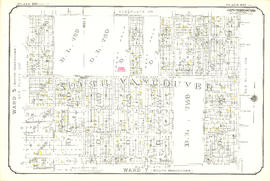
Plate 103: Sunset and Victoria [Victoria Drive - Forty-seventh Avenue - Windsor Street - Fifty-seventh Avenue]
![Plate 104 [Quebec Street to False Creek to Manitoba Street to Dufferin Street]](/uploads/r/null/b/3/b/b3b42c0352bed859e94ea30004ddb12475eea99c16a153542be22e644023b5ac/98b44bb6-b7b2-4f4c-aa2e-1d090030146e-1974-100_142.jpg)
Plate 104 [Quebec Street to False Creek to Manitoba Street to Dufferin Street]

Plate 104: Victoria and Killarney [Rupert Street - Forty-sixth Avenue - Victoria Drive - Thirty-sixth Avenue]
![Plate 105 [Front Street to False Creek to Quebec Street to Dufferin Street]](/uploads/r/null/a/f/b/afbb9be25514350d408eefa5865173e3a489ecdb6752d6b3096564052b234ca4/8c126ea6-16bb-4f0b-8131-a16f2a686d95-1974-100_142.jpg)
Plate 105 [Front Street to False Creek to Quebec Street to Dufferin Street]
![Plate 105: Killarney [Park Street - Forty-sixth Avenue - Rupert Street - Fifty-sixth Avenue]](/uploads/r/null/3/f/2/3f2506180ab01b1bb3e8b93fc8556eaf993c3fed6a652c75cb5f9c1d7a3e58b5/f47931f6-b379-41cb-a6a7-df51e419ab26-MAP342b_142.jpg)
Plate 105: Killarney [Park Street - Forty-sixth Avenue - Rupert Street - Fifty-sixth Avenue]
![Plate 106 [Manitoba Street to Dufferin Street to Alberta Street to Fifth Avenue]](/uploads/r/null/a/2/8/a288bcdc881a84d269c058cb38c117c43ef34c68d4a36dd1ffa72bfc2a46ba60/2d5baff6-456c-4406-9faf-fdd562e492b0-1974-100_142.jpg)
Plate 106 [Manitoba Street to Dufferin Street to Alberta Street to Fifth Avenue]