
Aerial photograph of P.N.E. grounds
- AM281-S8-: CVA 180-1469
- Item
- 1947
11 results with digital objects Show results with digital objects
Aerial photograph of P.N.E. grounds

Aerial view looking northeast over Hastings Park
Item is a photograph depicting an oblique view showing Renfrew Street, the Hastings Park race track, the amusement park including the roller coaster, exhibition buildings, Callister Park and the houses between Oxford Street, Triumph Street, Kaslo Street and Renfrew Street.
![[Aerial view of] British Pacific Properties [and North Vancouver]](/uploads/r/null/1/4/14644a75d43dd6a85d7a3c082e63134f4994ac268e97d1c0940f786b344bbd7e/46041e12-d683-4b08-81b0-797947030f8f-A23485_142.jpg)
[Aerial view of] British Pacific Properties [and North Vancouver]
Part of Major Matthews collection
Oblique view. Photograph shows Lions Gate (First Narrows) Bridge

Aerial view of Coal Harbour and Stanley Park
Part of City of Vancouver fonds
![[Aerial view of Gibson's from 1000 feet]](/uploads/r/null/d/5/d58c7a9e607bc9f48df5886422ab0aba4830b659d95dc8901154f7dd62e737dd/5636f7ef-5742-455c-8626-5939b6fe11c5-A23483_142.jpg)
[Aerial view of Gibson's from 1000 feet]
Part of Major Matthews collection
Aerial view of industrial buildings

Aerial view of Little Mountain area
Item is an aerial photograph showing an oblique view of the Little Mountain area.
Aerial view of metropolitan area of Vancouver, British Columbia


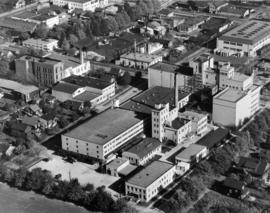
Aerial view of United Distillers and other industrial buildings near the Fraser River
Item is a photograph showing various buildings, including the Harwoods whiskey company and United Distillers, near SW Marine Drive.
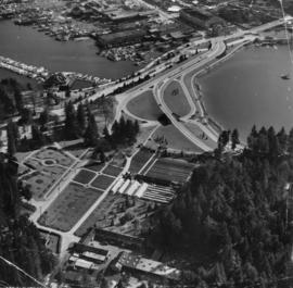
Stanley Park Georgia Street entrance
Photograph shows Coal Harbour, Lost Lagoon, greenhouses, and Stanley Park Armouries.
![Vancouver looking east from [Howe Sound]](/uploads/r/null/6/6/66fa4a6e8bb1ab5d20d8f951fa93ad57dd828be645aff6d182d88a8b36c69281/69bee6e1-54a6-4c8f-a7db-043e03b4dfe6-A23503_142.jpg)
Vancouver looking east from [Howe Sound]
Part of Major Matthews collection
Oblique view. Photograph shows Point Grey, University of British Columbia and University Endowment Lands.
Typewritten letter from Hunting Survey Corporation Limited on verso of print.