
Ferguson Point and Third Beach area
- VPK-S625-: CVA 392-1768
- Item
- Sep. 7, 1961
109 results with digital objects Show results with digital objects
Ferguson Point and Third Beach area


Aerial view of New Brighton Park site, looking west along waterfront toward foot of Renfrew Street
Part of Wilson family fonds

Aerial view of New Brighton Park site, looking east from Renfrew Street
Part of Wilson family fonds
Image shows grain elevators and Canadian Pacific Rails.
![[Aerial view of Vancouver General Hospital complex]](/uploads/r/null/c/c/b/ccbd0b591ebec85e171caa06a1ebf508517f73a7f475af01cecc469616c2990c/c26a808e-5db5-4adb-a9e4-37fbf69526f0-CVA1399-623_142.jpg)
[Aerial view of Vancouver General Hospital complex]
Oblique view showing King Edward High School and False Creek
![[Aerial view of Vancouver General Hospital complex]](/uploads/r/null/0/b/0/0b051003f4129ccb3a10f83c721878865509cd6ebfc12da14ed1309cec7b5aa0/f30b5587-d175-4041-ad8c-5703a5db260b-CVA1399-624_142.jpg)
[Aerial view of Vancouver General Hospital complex]
Oblique view showing King Edward High School and False Creek
![[Aerial view of] downtown bounded by Burrard Street, West Georgia Street, Granville Street and Sm...](/uploads/r/null/9/1/a/91aa0079c35a13cc3a22b0f7df0fb214970095aab0b5d871e09523e0499e3dac/42b18aee-e75f-4548-9e3a-bf196c0130ce-CVA145-17_142.jpg)
Part of City of Vancouver fonds
![[View looking northeast from north shore of False Creek over Smithe Street]](/uploads/r/null/8/f/6/8f6d7814ac04d1498743ba52bf07caf7e8dd2cf0290eb319665712b1edfdc180/c5c831e7-835b-48ff-8c87-5c157412dc0c-CVA145-2_142.jpg)
[View looking northeast from north shore of False Creek over Smithe Street]
Part of City of Vancouver fonds
![[Aerial photograph of north Burnaby near intersection of Lougheed and Sperling]](/uploads/r/null/a/c/acb6598698ac88b27910cc65b590d05b02972403e78fecc5ae1a368cd0c4886b/32a0806e-9249-4407-8edf-f969bf2582fb-A38736_142.jpg)
[Aerial photograph of north Burnaby near intersection of Lougheed and Sperling]

Lions Gate Hospital Area : North Vancouver Medical Centre Area
Areial photograph showing oblique view of Lions Gate Hospital

Aerial photograph of downtown Vancouver and Burrard Inlet waterfront
![[Aerial photograph of downtown Vancouver and Burrard Inlet waterfront]](/uploads/r/null/8/8/880f3eb359e4ba87a53dbb1528c9a52637f0890bd7fa1f026f2a2f8d55770b5f/07f1720e-3884-4019-874b-7ae1f538a5ea-A38733_142.jpg)
[Aerial photograph of downtown Vancouver and Burrard Inlet waterfront]
Aerial photograph looking west down Georgia Street, showing Lost Lagoon and Coal Harbour
![[Aerial photograph of north Burnaby near intersection of Lougheed and Sperling]](/uploads/r/null/f/6/f6d5ee2897afb7fca08a02c5516b73fa64f9dffc0b96e41335272f5049bff318/5e860ead-2105-466e-9535-74449508fa1c-A38734_142.jpg)
[Aerial photograph of north Burnaby near intersection of Lougheed and Sperling]
![[Aerial photograph of north Burnaby near intersection of Lougheed and Sperling]](/uploads/r/null/0/4/0402a7c6f7e8a28c8ca96ea5b930f8be591de0a42bfa4e4d588b57d8242e3df2/89b183bb-b4c9-4610-bd3d-233b78ca3218-A38735_142.jpg)
[Aerial photograph of north Burnaby near intersection of Lougheed and Sperling]
![[Aerial photograph of downtown Nanaimo B.C.]](/uploads/r/null/6/5/65cde66194e385688e218734e0d220ed5ee7ad328ef1509e29b092e2bccd990c/9b09da99-a3e3-4278-bfef-a729495916b4-A38724_142.jpg)
[Aerial photograph of downtown Nanaimo B.C.]
Aerial view of ferry terminal, downtown Nanaimo
![[Aerial photograph of downtown Nanaimo B.C.]](/uploads/r/null/9/b/9b5d6fcf945972bb10cacdedfe59a314267f99d1ef992e2e700a51cbe2bc7f80/6c0c2c60-d22a-48c1-b603-cdfa6801ce19-A38723_142.jpg)
[Aerial photograph of downtown Nanaimo B.C.]
Aerial view of shopping centre in downtown Nanaimo

Aerial photograph showing unidentified cannery in West Vancouver

Aerial photograph showing oblique view of Royal Columbian Hospital complex and surrounding neighborhood

Aerial photograph showing oblique view of Royal Columbian Hospital complex. Industrial development on the Fraser river visible in the background

Aerial view of P.N.E. grounds and surrounding area looking northeast

Aerial view of P.N.E. grounds looking northeast

Aerial view of P.N.E. grounds and surrounding area looking north

Aerial view of east half P.N.E. grounds looking south
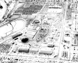
Aerial view of P.N.E. grounds looking east

Aerial view of P.N.E. grounds and surrounding area looking east

Aerial view of P.N.E. grounds and surrounding area looking northeast

Aerial view of P.N.E. grounds looking southeast

Aerial view of P.N.E. grounds looking northeast

Aerial view of P.N.E. grounds looking south

Aerial view of P.N.E. grounds and surrounding area looking northeast

Aerial view of P.N.E. grounds and surrounding area looking east

Aerial view of P.N.E. grounds looking southeast

Aerial view of P.N.E. grounds looking east

Aerial view of P.N.E. grounds and surrounding area looking west

Aerial view of P.N.E. grounds and surrounding area looking east
![Pacific Coliseum : [aerial view of partially completed construction of Pacific Coliseum]](/uploads/r/null/d/c/dc912c3674861fdf8170c8af413b0fdcd60b92c885b984b4c27897efb0f7982f/1b944e3c-667b-49a3-b7d1-b5a485a7427c-CVA180-5921_142.jpg)
Pacific Coliseum : [aerial view of partially completed construction of Pacific Coliseum]

Aerial view of partially completed construction of Pacific Coliseum

Aerial view of partially completed construction of Pacific Coliseum

Aerial view of partially completed construction of Pacific Coliseum

Aerial view of partially completed construction of Pacific Coliseum

Aerial view of partially completed construction of Pacific Coliseum

Aerial view of partially completed construction of Pacific Coliseum

Aerial view of area surrounding Pacific Coliseum construction looking east

Aerial view of partially completed construction of Pacific Coliseum

Aerial view of partially completed construction of Pacific Coliseum

Aerial view of area surrounding Pacific Coliseum construction looking northeast

Aerial view of area surrounding Pacific Coliseum construction looking northeast

Aerial view of area surrounding Pacific Coliseum construction looking northeast

Aerial view of area surrounding Pacific Coliseum construction looking east
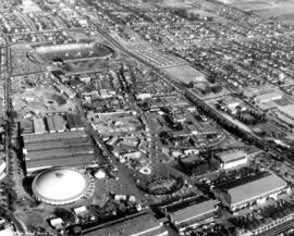
Aerial view of P.N.E. grounds looking southeast