
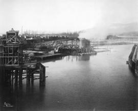
West half Granville Island before filling
- AM54-S4-1-A-10-: A-8-24.2
- Item
- [ca. 1916]
Part of Major Matthews collection
15 results with digital objects Show results with digital objects
West half Granville Island before filling
Part of Major Matthews collection
West half Granville Island before filling
Part of Major Matthews collection

Part of Major Matthews collection
Photograph shows water, tugs, log booms and an industrial section of shoreline.
![Ocean Falls [harbour dredging]](/uploads/r/null/1/e/1e7e09e17dcb3d0b28a30119bceaa2f16244f3ff09e4db0d582bf8f4d720d60c/64cfdccc-461e-4627-b615-908f9ba91921-A31758_142.jpg)
Ocean Falls [harbour dredging]
Part of Major Matthews collection
![Filling of government dock at Victoria, B.C. [Victoria outer dock]](/uploads/r/null/a/c/ac3dfcbfd7931077bc2fd044d9ac56f115bc15a0a358e22caf0d0dd50edde8b7/dcf75c65-ad8b-4b52-b57c-bf2b8a6aefd3-A31777_142.jpg)
Filling of government dock at Victoria, B.C. [Victoria outer dock]
Part of Major Matthews collection
![Filling of government dock at Victoria, B.C. [Victoria outer dock]](/uploads/r/null/a/4/a407ab35e25717806ed19dee13e037e030e5e4a94cee438b0b27b6b923de43ce/82cdb86b-0638-46f6-8815-f9a538f91041-A31776_142.jpg)
Filling of government dock at Victoria, B.C. [Victoria outer dock]
Part of Major Matthews collection
![[East half Granville Island before filling]](/uploads/r/null/7/7/779c84832492846bbaaf82b09675d06ff7c3ab6303167b3827dc162b403089ef/daa3991d-6801-47d2-a003-486fb768fb00-A31771_142.jpg)
[East half Granville Island before filling]
Part of Major Matthews collection

East half Granville Island before filling
Part of Major Matthews collection
File shows harbour, log boom and industrial shoreline.

East half Granville Island before filling
Part of Major Matthews collection
![[East half Granville Island before filling]](/uploads/r/null/3/5/35c9254407dcb353fee92a4f8f428fb575c8c83ae212ce77b57e6ecf0bbb2b9f/2b18b1d3-56f8-4e24-89f3-345aa9ea9358-A31772_142.jpg)
[East half Granville Island before filling]
Part of Major Matthews collection

East half Granville Island before filling
Part of Major Matthews collection
File shows harbour, log boom and industrial shoreline.

East half Granville Island before filling
Part of Major Matthews collection

East half Granville Island before filling
Part of Major Matthews collection
Photograph shows harbour, log boom and wharves.
![[Dredging] drill](/uploads/r/null/8/b/8bb6d6caa508ebafbe54a8a3d3a65f79ffaadd1478574fd193f15aa473444465/64564f45-3036-423d-a547-db9887092a15-A31773_142.jpg)
Part of Major Matthews collection

Coal Harbor Vancouver. Height of Water In Upper End 9 ft. above. Zero
Part of Major Matthews collection
Panoramic view showing Lost Lagoon, the Stanley Park Causeway under construction and the Vancouver Rowing Club.