![The nave, north and south transepts, from the chancel [St. Andrew's Wesley United Church]](/uploads/r/null/e/9/e926c427f686de90fffbe61232de072e6e368bd15144818b1c94feeecb7cb389/faf65e2b-d72c-499f-ab6f-31b25ee05bd5-A02032_142.jpg)
The nave, north and south transepts, from the chancel [St. Andrew's Wesley United Church]
- AM336-S3-3-: CVA 677-221.10
- Item
- [1933]
208 results with digital objects Show results with digital objects
The nave, north and south transepts, from the chancel [St. Andrew's Wesley United Church]
![Great organ, St. Andrew's Wesley [United] Church](/uploads/r/null/3/0/3061fcdc3fc975c626a581f7a6d8d8530612ee3fee362fbb65febf192759f162/a1aa9e1c-2885-4ba3-975e-8622577bdaeb-A02042_142.jpg)
Great organ, St. Andrew's Wesley [United] Church
Photograph shows the church organ pipes.

Dining hall, Anglican College, Vancouver, B.C.
Photograph shows tables and chairs, window, ceiling beams, and other details of the room.

Photograph shows the choir of the Wesley Methodist Church posed in front of the church organ before the church's amalgamation with St. Andrew's Presbyterian Church to form St. Andrew's Wesley United Church.

Photograph shows the choir of the Wesley Methodist Church posed in front of the church organ before the church's amalgamation with St. Andrew's Presbyterian Church to form St. Andrew's Wesley United Church.
![Chapel of Anglican College [later part of the Vancouver School of Theology]](/uploads/r/null/d/a/da3f561c54d090f5b91662493f7c250c51f85bb3669b06376c4577e8aac78160/0f086191-f839-4bba-aea4-1125da8c31d1-A01993_142.jpg)
Chapel of Anglican College [later part of the Vancouver School of Theology]
Photograph shows interior of college, with chairs, podium, altar, and other items.
![Interior of Pioneer's Association Museum (Old Hastings Mill Store) [1575 Alma Street, Vancouver]](/uploads/r/null/e/3/e3dc34ac96b39496a16764ca9f2f3cbd29f527a89f61fc99604b9ab117605c27/b402c75d-f487-4410-a534-1f39150c1810-A02002_142.jpg)
Interior of Pioneer's Association Museum (Old Hastings Mill Store) [1575 Alma Street, Vancouver]
Photograph shows a piano and other artifacts in the museum.

![[Houses in Mount Pleasant]](/uploads/r/null/f/9/f9cfae1b728e3983b8f1159363fbd867d1483954da987c6ecfd6a1c0d33db277/89e698d2-20cd-45f2-833f-42e0f90a492e-A02351_142.jpg)
Photograph shows two houses. Two men are standing on the front walkway of one house
![[View of street at sunset]](/uploads/r/null/3/2/327d00083c28f5a628cf671d79a4ee682189452a4603f984501908565b0a717f/96da385e-1c23-4f49-a785-2570631425a0-A02369_142.jpg)
Note on original mounting board reads: "Hastings St. ca. 1904"
![[Willows and bridges at Stanley Park]](/uploads/r/null/5/3/53d080a378f89be5e7362a7d3a855809b4127730940d1824a3c179e319ba13f7/604fe6a6-0cfb-4b72-bf12-e95d1256d685-A02370_142.jpg)
[Willows and bridges at Stanley Park]
Notes on original mounting board read: "Weeping willows, in their winter sleep. Stanley Park, Vancouver, B.C. Van. Nat. History. - Timms"
![[Five men at] Sub-arctic lake, Garibaldi National Park](/uploads/r/null/9/e/9ef6c38f5e5a9738dad7c04bb5d0a46fc72a172b4bd13b0acdc77473cacd8688/39c34211-5803-4dbc-8991-96d25fd4e662-A02371_142.jpg)
[Five men at] Sub-arctic lake, Garibaldi National Park
Note on original mounting board reads: "Lakes in the sub-arctic, 5500 ft. up. Age-old ice and the annual snowfall. Garibaldi Nat. Park. Van. Nat. History - Timms."
![[Side view of sand drifts, Boundary Bay]](/uploads/r/null/8/9/897b31793bc2d55755f4b4c7455edb0f42ef168e269e747396751d88443f48d8/e4a8b3b1-f80f-4987-a885-0061378fb176-A02372_142.jpg)
[Side view of sand drifts, Boundary Bay]
Note on original mounting board reads: "Boundary Bay, B.C. Melting of the ice age, Fraser River. Drift of sand and iron stained pebbles."
![[Willows and bridges in Stanley Park]](/uploads/r/null/e/4/e40cb6940b9e141aa52e3b9b3566f1f6f283b3f6d419c804fc1af6f121e50e23/99a3706c-26bd-4ff6-9dc7-0a3cf6895f00-A02381_142.jpg)
[Willows and bridges in Stanley Park]
A note on the original mounting board reads: "Landscape. The Willow's looking glass. Winter in Stanley Park, Vancouver, B.C. 1939. Van. Nat. History - Timms."

Rock splitting tree - Bowen Island
A note on the original mounting board reads: "Rock splitting trees fight for life. Bowen Island. Van. Nat. History. Timms."
![Vancouver Natural History Society [members assembled at] Trout Lake](/uploads/r/null/6/0/60faecd5561679711f20ff90f76a36517f7c966954f934517a3900aac27f5f87/663d10e3-9600-4fff-b713-7feb118214a6-A02379_142.jpg)
Vancouver Natural History Society [members assembled at] Trout Lake
A note on the original mounting board reads: "Vancouver Natural History Society. Our first outing at Trout Lake, Spring time 1927 - Philip Timms Photo."

Pebble filled volcanic mud, False Creek
A note on the original mounting board reads: "Geology. Pebble filled volcanic mud. Mounds, south cliffs of False Creek, Vancouver, B.C. Van. Nat. History - Timms"
![[Trees in] Garibaldi National Park](/uploads/r/null/8/1/8184ec455cb01c2d9ae30f7ab3088e9dbe2257bd6c990e1fdcf30f726169658d/a98029bf-6aba-4a4f-9873-b74b23a83532-A02377_142.jpg)
[Trees in] Garibaldi National Park
A note on the original mounting board reads: "Garibaldi National Park 1922 one tree cut down by snow avalanche."
![[Interior of] Bell tower, St. James' Anglican Church [303 East Cordova Street]](/uploads/r/null/8/4/84d65f1b33de71dbafe6d3e645d41293298cc5db747fc79c2448fdf88e4668d9/4ba0c3b3-7b23-4fc1-9a98-56be7e88b7e8-A02376_142.jpg)
[Interior of] Bell tower, St. James' Anglican Church [303 East Cordova Street]
A note on the original mounting board reads: "Industry. Saturday afternoon. Stop work. Bell Tower, St. James' Anglican Church, Vancouver, B.C. Van. Nat. History - Timms."
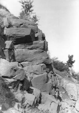
![[Wedge shaped rocks]](/uploads/r/null/a/3/a352b264d91ed0365918d3b75eee70621d4f2968675d734ce9b3c3e38cf645b8/3998514c-6f83-49ac-8b02-d4d0b1db0be6-A02375_142.jpg)
A note on the original mounting board reads: "The 'Wedge." The disintegration of rock formation is an interesting field for the nature photographer. Wet, frost, debris, and vegetation penetrates the fractures in the rock, forcing the mass apart to fall below and form the Talus. Sea Coast, near Vancouver, B.C. Philip Timms, A.R.P.S."
![[Tidal pool at] Bowen Island](/uploads/r/null/c/9/c9e690827c17ac0dca03eaf7388235e0e83e7859e9114c4965cbbf280e244dde/0895f359-83dc-41e7-a5fa-80b13336913a-A02374_142.jpg)
A note on the original mounting board reads: "Geology. Pools of sea water, left by falling tides, are a means with frost and heat, of splitting rocks at their jointing. Bowen Island, Vancouver, B.C. Van. Nat. History - Timms."
Five sided basalt, False Creek
A note on the original mounting board reads: "Geology. Five sided basalt. Eruptives of False Creek, south hillsides. Vancouver, B.C. Van. Nat. History - Timms."

Volcanic mud and basaltic outcropping, False Creek
A note on the original mounting board reads: "Geology. Volcanic mud and basaltic outcropping. South side of False Creek, Vancouver, B.C. Van. Nat. History - Timms."

Cross section of 275 year old Fir tree, Bowen Island
A note on the original mounting board reads: "Forestry. Section of a 275 year old Fir tree. Bacteria opens the way to the weather. Bowen Island. Van. Nat. History - Timms."
![[Weathered rocks in] Capilano River](/uploads/r/null/6/a/6a1dbf92fc242e68f5a266bc39d8472891e69ded08970b12afb3efe2b24bed03/15ba65e2-d9b1-4fe9-a022-b594a8baf144-A02382_142.jpg)
[Weathered rocks in] Capilano River
A note on the original mounting board reads: "Weathering. Sharply fractured rocks fall into the streams and become rounded in shape by the ever-moving currents. Capilano River, Vancouver, B.C. Van. Nat. History - Timms."

A note on the original mounting board reads: "'The morning's promise.' Early morning on Howe Sound, Vancouver, Canada. Tidal salt water of the Pacific Ocean, explored by Captain Vancouver, over 160 years ago."

A note on the original mounting board reads: "Geology. Hill-tops of False Creek, Volcanic debris, where play the city's children, Vancouver, B.C. Van. Nat. History - Timms."

Arbutus Tree on Island Summit, near Hood Point, Howe Sound
A note on the original mounting board reads: "Forestry. The Arbutus Tree on Watch. Island Summit, off Hood Point, Howe Sound, Vancouver, B.C. Van. Nat. History - Timms."

A note on the original mounting board reads: "Seascape. Low tide, salt water, and the disintegrating of shoreline. Miller's Landing, Howe Sound, Vancouver, B.C. Van. Nat. History - Timms."
![[View of Howe Sound, with dead tree in the foreground]](/uploads/r/null/9/2/9273475a95f0e734b78ee2b6ce5481ff85ebb6cd2690b5220d08dfdbda2c760d/8912457f-258e-4e66-99cd-d38feaf88752-A02390_142.jpg)
[View of Howe Sound, with dead tree in the foreground]
A note on the original mounting board reads: "It is possible that this dead tree witnessed the comming of Capt. Vancouver as he explored the Sound past Hood Point, Bowen Island. Van. Nat. History - Timms."

Rocky ramparts of Bowen Island
A note on the original mounting board reads: "Geology. Rocky ramparts of Bowen Island. Among the Igneous formations. Miller's Landing, Hower Sound. Van. Nat. History - Timms."

A note on the original mounting board reads: "Geology. Sand cliffs at Boundary Bay, near Vancouver, Ancient sea bottom laid down when the Gulf of Georgia was fresh water. Van. Nat. History - Timms."

Photograph shows docks and boats, commercial and industrial buildings, and houses in the distance.
A note on the original mounting board reads: "Old Sand lenses at Second Beach undermined by wave erosion. Van. Nat. History - Timms."
![[Tree growing around rock], Bowen Island](/uploads/r/null/0/5/05c8ec5cf8e2c8f40f12082ea6fb7152fda17623c39bf9eba2bfab9e0d354d95/29e74b50-3458-41f6-bc87-58bffa7bf8dc-A02399_142.jpg)
[Tree growing around rock], Bowen Island
A note on the original mounting board reads: "The trees teach men how to fight difficult problems. Splitting the rocks, Bowen Island. Van. Nat. History - Timms."
![[Panorama view of Vancouver looking north from Nelson Street]](/uploads/r/null/a/2/c/a2cbf67d9e217c29ca20d8e07b9e19e016002e1fa58bc96f21141f17b5271c84/52df33e9-d34f-45a7-bef4-bb7a2566c630-CVA677-656_142.jpg)
[Panorama view of Vancouver looking north from Nelson Street]
Prominent buildings in photograph are: Manhattan Apartments (784 Thurlow Street), Marine Building (355 Burrard Street), Hotel Vancouver (900 West Georgia Street), Provincial Court House (750 Hornby Street); Second Hotel Vancouver (Granville Street), Vancouver Block (736 Granville Street), First Baptist Church (969 Burrard Street) and St. Andrew's-Wesley United Church (1012 Nelson Street).
![[Pedestrians on sidewalk at Granville and Pender Streets]](/uploads/r/null/0/c/0c8bf8835393626cbd0053bc597af02ed3bc986ef3cfc113fd077b552034000e/a47bc6ae-1a2e-4180-9b51-f6b51d1bf1f0-A02491_142.jpg)
[Pedestrians on sidewalk at Granville and Pender Streets]
Photograph shows pedestrians, streetcars, automobiles, a C.P.R. sign, and the corner of the Rogers building, including O.B. Allan Jewellers.
![[Pedestrians on sidewalk of 500 block of Granville Street]](/uploads/r/null/7/1/7126175ce575e54d0d75b5b7a58a62eade59ac2bbdbcc7290427a7f271832d02/ccc72e8c-93a9-4ee2-b8c8-a6831a8e7b42-A02490_142.jpg)
[Pedestrians on sidewalk of 500 block of Granville Street]
An accompanying label reads: "Commonwealth City Life, 50 years ago in Vancouver, Canada. No autos, no chewing gum bespattered asphalt roads, no radios or television. Memory recalls the sound of gentle footsteps along the 12 ft. wooden plank sidewalks. The long skirts and the "respectable" street cleaners of the period. Timms, Vancouver Natural History Society. 1904-1954."

Corner Hastings and Richards Streets. Time of the visit of our King and Queen
Photograph shows Hastings Street, looking west, decorated with flags and signs. Photograph also shows streetcars, automobiles, and pedestrians.

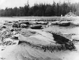
Pot holes drilled by running stream, Vancouver Island
Photograph shows weathered rocks.
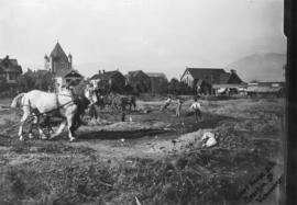
Clearing site for Court House on Georgia Street
Photograph shows horses and men clearing land.
![[Granville Street near Pender Street, looking north, showing sign for Semi-Ready Tailoring]](/uploads/r/null/1/8/18e5f88a77032fa4077010395c66a954f9f6525eeb74e47c363fbc365a76424d/5e0ce98d-ca14-4d39-be49-d7caa1330521-A02360_142.jpg)
[Granville Street near Pender Street, looking north, showing sign for Semi-Ready Tailoring]
A label on the back of the photograph mounting reads: "Granville Street, near Pender. Looking North. A foggy day in the autumn. One auto, tram cars on left hand side, the hand cart, Rand Bros. office, Old Style sign of 'Semi-Ready.' The corner before the Rogers building was built."
![[View of Dupont Street, later Pender Street, Chinatown area]](/uploads/r/null/6/0/606e8b9b8cb0818a46e021cda095c9662964079d95d2021f028ca4b94e14f67b/c1f3750a-82c7-4c2c-b0c6-f71c0fff69c5-A02361_142.jpg)
[View of Dupont Street, later Pender Street, Chinatown area]
Photograph shows carts, people, and a dog in the middle of the street. Various commercial buildings are also shown.
![Dominion Bank building [207 West Hastings Street] under contruction, showing old Court House Dome](/uploads/r/null/e/f/ef0a358e8f8482368170e001fcb7c3fd29efd0496f1663714c8a3fe1efe62341/42bb7db4-040f-48e2-81c3-2cc101b3ed75-A02363_142.jpg)
Dominion Bank building [207 West Hastings Street] under contruction, showing old Court House Dome
Photograph also shows a horse-drawn cart, and two men leaning over a hand cart.

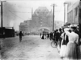
Parade, Cordova Street, Dominion Day
Photograph shows soldiers with band marching down street, with spectators on the sidewalks.
![[Businesses and produce carts on 400 block of Carrall Street]](/uploads/r/null/b/a/ba3afb730e1d31aa6078c129eb52b155aa07a1972b6501f71677e094c1072fe6/10eb7a0e-9980-4c7f-a8eb-700e6b0a58e5-A02353_142.jpg)
[Businesses and produce carts on 400 block of Carrall Street]
Photograph shows several horse-drawn carts in front of a commercial block. Businesses in the buildings include: Kwong Fat Yuen Co., Sam Kee and Co., Sun Sun Fine Tailoring.
![[View of Granville Street, north of Dunsmuir Street, in the rain]](/uploads/r/null/4/1/41ae90722326c6a1f9a2249e76f9dc0db1b903d8e054d682367f2212794d7053/4083214f-fccc-4550-bc95-1904f24ab65b-A02356_142.jpg)
[View of Granville Street, north of Dunsmuir Street, in the rain]
Photograph shows pedestrians on sidewalk and horse-drawn carriages in the street.
Photograph shows queue on both sides of the street, leading to the C.P.R. station.

Georgia Street at Hornby Street
Photograph shows horse-drawn carriages on street, including one for the Badminton Hotel; Christ Church Cathedral; and a building containing both a grocery store (Kyle Grocery) and a picture framing store (Timms Art Emporium), later the site of the Georgia Medical - Dental building, then Cathedral Place.
![[Five cars at Prospect Point, Stanley Park]](/uploads/r/null/9/a/9aa12bcb709c4f532bfe4f18b98e8df0e1641dd45b108c1609a7e00230ee0a8d/334f8307-3819-471b-acff-d4ca678b8b24-A02392_142.jpg)
[Five cars at Prospect Point, Stanley Park]
Photograph shows men, women, and children in cars around Prospect Point. Two young men and a child are seated on a tree stump.