
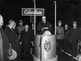
[A.W. Lundell, William Manson and Mayor W. Hardman on the platform at the launch of "The Canadian"]
- AM358-S1---: CVA 152-75
- Item
- [Apr. 24, 1955]
Part of H.A. Price collection
[A.W. Lundell, William Manson and Mayor W. Hardman on the platform at the launch of "The Canadian"]
Part of H.A. Price collection
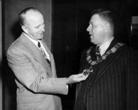
C. E. Thompson and unidentified individual wearing Mayor's chain
Part of Charles Thompson fonds

C. E. Thompson and unidentified individual wearing Mayor's chain, holding mace
Part of Charles Thompson fonds
![Canadian Pacific [Airlines] "Empress of [Vancouver" in the air]](/uploads/r/null/b/b/bb4c7a7b97f535a860c37dd1687e9ffbdd659e9981b5aa798a5047aaa0304be5/9faa21b4-94f2-47bb-801e-68444de1ed50-A23432_142.jpg)
Canadian Pacific [Airlines] "Empress of [Vancouver" in the air]
Part of Major Matthews collection
Oblique view. Airplane identified as Canadair Four CF-CPR 402
![Canadian Pacific [Airlines] "Empress of [Vancouver]" in the air](/uploads/r/null/5/1/51636b9581d5a98c5d1a2e9a940e68e7cf54290524ef44c878a1e3546d59f13f/0d7f17a2-5788-418a-b1bb-a387115cfd35-A23433_142.jpg)
Canadian Pacific [Airlines] "Empress of [Vancouver]" in the air
Part of Major Matthews collection
Airplane identified as Canadair Four CF-CPR 402
![[Canadian Pacific Airlines] "Empress of Vancouver" over city of Vancouver](/uploads/r/null/6/b/6ba4ed2071cb0964df7f0fc2336187077a7a9f4bd20495de3bb21849830457dc/8c45c9d3-f69c-47f4-9801-da5254d0abf4-A23430_142.jpg)
[Canadian Pacific Airlines] "Empress of Vancouver" over city of Vancouver
Part of Major Matthews collection
Oblique view
![Canadian Pacific map of Vancouver [west half]](/uploads/r/null/f/a/fa49266d21715d75ce93883012d471657dd058b90843927ec82b44d2bb42b007/f12ea9a5-4914-4db8-bda9-312aa2e2ccef-MAP10_142.jpg)
Canadian Pacific map of Vancouver [west half]
Part of City of Vancouver Archives technical and cartographic drawing collection
Item is a portion of a map depicting lands granted to the Canadian Pacific Railway in Vancouver. The portion depicts the West End and northern Kitsilano.

Canadian Pacific Railway - Miss S. Clifford, Wiper
![Canadian Pacific Railway - [woman] washing car](/uploads/r/null/e/1/e1c1a6fcef59ceac0f2df375f68142a1a05ba29cfd112ef5afff07284a1e9479/d396d81a-cf4c-4c73-a866-466d25b3541b-A03634_142.jpg)
Canadian Pacific Railway - [woman] washing car
![Canadian Pacific Railway - [women] cleaning engine [2716]](/uploads/r/null/2/1/21a8d706f62be21243b4102972897c1d361b763b194b2ece4b6a2e6c0f0cdf1a/e4af7985-2844-44d9-97c8-ad1620ff0c5b-A14030_142.jpg)
Canadian Pacific Railway - [women] cleaning engine [2716]
![[Canadian Pacific Railway docks at the foot of Granville Street]](/uploads/r/null/f/6/f640a24e1e67eda5e039d660b8f7b97f8ca9c90750dc88e77e02e8ff00ffc3fc/c32fd062-712d-4c3a-8a51-4bae34226e6a-A63436_142.jpg)
[Canadian Pacific Railway docks at the foot of Granville Street]
Part of Major Matthews collection
Photograph shows Pier C, Pier D, Canadian Pacific Railway yards.
![[Canadian Pacific Railway Piers B, C and D and "R.M.S. Aorangi"]](/uploads/r/null/7/3/732d51489af8d536bb1c0180619efb76de2d683a132af4a68c5926157a550bbf/cdcb24ad-c919-4f86-8ebc-ab3af236f267-A63443_142.jpg)
[Canadian Pacific Railway Piers B, C and D and "R.M.S. Aorangi"]
Part of Major Matthews collection
Photograph also shows the Immigration Building.

Item is a map showing land subdivision in downtown Vancouver around Burrard Inlet, and the route of the Canadian pacific Railway along the south shore of Burrard Inlet.

Part of City of Vancouver Archives technical and cartographic drawing collection
Map shows a survey conducted by the Canadian Pacific Railway of English Bay, Burrard Inlet and Coal Harbour, including a rough outline of area and lots. Note on map reads "Certified as a correct plan showing the land required for right of way Burrard Inlet B.C., February 22, 1886. H.J. Cambie, Engineer in Charge." Map is certified as correct and signed by various C.P.R. officials, including W.C. Van Horne.
![[Canadian Pacific Railway station and S.S. "Princess Mary" at Pier D]](/uploads/r/null/7/6/769da866be87d82bcd72056c99d61da7da542fcf9ebe228c7b84427db2b91fe5/994d4a92-5809-49a8-8f99-99adbb2c2f39-A63438_142.jpg)
[Canadian Pacific Railway station and S.S. "Princess Mary" at Pier D]
Part of Major Matthews collection
![[Canadian Pacific Railway station, S.S. "Princess Mary" at Pier D]](/uploads/r/null/7/8/781a7d3fee3af13d3b537bba4f7ed0643a96ecf680c22d0fa96e3c52f8bd0e48/5d29acdf-e6da-4e6c-bb6a-7c42d5efa497-A63439_142.jpg)
[Canadian Pacific Railway station, S.S. "Princess Mary" at Pier D]
Part of Major Matthews collection
Photograph also shows C.P. passenger and freight cars and hotel buses.
![Canadian Pacific Railway [women wiping-down engine]](/uploads/r/null/9/6/96c1ddb39154e1d487967560e5f0c95c0105d9ac9977068c89464f4682360aa7/489cd943-51cd-4fbd-8efc-6cdba65679b2-A03632_142.jpg)
Canadian Pacific Railway [women wiping-down engine]
![[Canadian Pacific Railway yard, Pier D, ships and waterfront]](/uploads/r/null/4/0/40723795358f5b22b8659eaf69c6e435c53d5fedc4f43e3c463ae96b8700c6f1/47c6f457-b958-4bb6-af35-0e56071bab26-A63442_142.jpg)
[Canadian Pacific Railway yard, Pier D, ships and waterfront]
Part of Major Matthews collection
Photograph also shows a vehicle ferry crossing the inlet.
![[Chief Justice Sloan speaks before the departure of C.P.R. "The Canadian"]](/uploads/r/null/4/4/443cba6712fa26f949a586478ddedec1b8c34aef54b7421587f229f3d3da0a8b/f1875220-2e3a-4417-915d-64b7dc739bd6-A70836_142.jpg)
[Chief Justice Sloan speaks before the departure of C.P.R. "The Canadian"]
Part of H.A. Price collection
Photograph shows various officials and two R.C.M.P. officers. Men identified in the photograph are: Mayor F.J. Hume, Hon. E.W. Hamber, Chief Justice Harris, William Mason, Commander Stevenson and Assistant Commissioner C.E. Rivett-Carnac.
![C.P.R. [Canadian Pacific Railway] Station (Waterfront Station), exterior entrance](/uploads/r/null/a/3/a/a3aa77c3f092730794ebf981766cbaa9f8a7f6b5225d2681ce0221f2bd2e297b/11247e60-2a07-42ff-a94b-a9c26cfab226-CVA70-01_142.jpg)
C.P.R. [Canadian Pacific Railway] Station (Waterfront Station), exterior entrance
Part of Art Grice fonds
Item is a photograph of the entrance columns of the third C.P.R. Station (601 West Cordova Street), also known as Waterfront Station, located at Granville Street and Cordova Street.
![C.P.R. [Canadian Pacific Railway] Station (Waterfront Station), interior concourse](/uploads/r/null/6/9/1/691dda1bf40a991b5f274acd3c573ce6c541562041fe5699c56d7130e50074bf/72300492-c1ca-4723-a44e-127362bcaebc-CVA70-02_142.jpg)
C.P.R. [Canadian Pacific Railway] Station (Waterfront Station), interior concourse
Part of Art Grice fonds
Item is a photograph of the concourse of the third C.P.R. Station (601 West Cordova Street), also known as Waterfront Station, located at Granville Street and Cordova Street. The length of the room, mostly empty, is visible, revealing a police officer and travellers sitting on benches at either end of the room. Detail of architectural features can be seen, including columns and capitals, decor, mouldings, a wall clock, and the coffered ceiling. Travelers sit at the waiting benches.
![C.P.R. [Canadian Pacific Railway] Station (Waterfront Station), interior concourse wall](/uploads/r/null/a/3/b/a3b9565aef2be59ce914c3369ba932e5acd519813d9463c048e74c64613c25d3/4ac657ae-ae98-4830-b079-56c65fdcfb3f-CVA70-03_142.jpg)
C.P.R. [Canadian Pacific Railway] Station (Waterfront Station), interior concourse wall
Part of Art Grice fonds
Item is a photograph of one of the ends of the concourse of the third C.P.R. Station (601 West Cordova Street), also known as Waterfront Station, located at Granville Street and Cordova Street. Detail of architectural features can be seen, including columns and capitals, decor, mouldings, the wall clock, and the coffered ceiling. Travelers sit at the waiting benches.

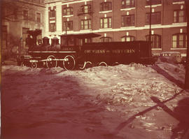
C.P.R. No. 1, Countess of Dufferin steam locomotive
Item is a photograph of the Countess of Dufferin steam locomotive, C.P.R. No. 1, surrounded by snow, at its outdoor display location in Winnipeg.

[C.P.R. President N.R.C. Crump being interviewed by CBC during the launch of "The Canadian"]
Part of H.A. Price collection
![[C.P.R. President N.R.C. Crump being interviewed during the launch of "The Canadian"]](/uploads/r/null/1/9/19c97210702841eeb9287763959a5f8c7acc9cebf707d891b16dcd4f3df8be27/6048da38-b563-4f9c-a240-a1f6891a5e1d-A70838_142.jpg)
[C.P.R. President N.R.C. Crump being interviewed during the launch of "The Canadian"]
Part of H.A. Price collection

[C.P.R. President N.R.C. Crump (middle) being interviewed during the launch of "The Canadian"]
Part of H.A. Price collection

Item is a photograph of a high angle view looking northeast over the C.P.R. train tracks at Vancouver Harbour.
C.P.R. unveiling of The Canadian
Part of Hamber family fonds
![[CPR Vancouver Terminal]](/uploads/r/null/6/3/6321675b658f8eb5b5ba29d30864853ae686b6d3b8d24bdabcf921047af002c4/9b724deb-5c0d-4f32-be61-8fd708c3507f-A70765_142.jpg)
Part of H.A. Price collection
Photograph shows the CPR Vancouver Terminal. View is looking east. Photograph shows the railsidings, the station, and the commercial piers.

Entertainment at event for C.P.R. directors
Part of Hamber family fonds

Entertainment at event for C.P.R. directors
Part of Hamber family fonds

Entertainment at event for C.P.R. directors
Part of Hamber family fonds

Eric W. Hamber and others dining at event for C.P.R. directors
Part of Hamber family fonds

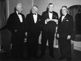
E.W. Hamber and four fellow C.P.R. directors
Part of Hamber family fonds

E.W. Hamber and two fellow C.P.R. directors
Part of Hamber family fonds

E.W. Hamber at the C.P.R. event for The Canadian
Part of Hamber family fonds

E.W. Hamber at the C.P.R. event for The Canadian
Part of Hamber family fonds

E.W. Hamber at the C.P.R. event for The Canadian
Part of Hamber family fonds

E.W. Hamber at the C.P.R. event for The Canadian
Part of Hamber family fonds

E.W. Hamber at the C.P.R. event for The Canadian
Part of Hamber family fonds

E.W. Hamber speaking with a man at event for C.P.R. directors
Part of Hamber family fonds

E.W. Hamber with men at event for C.P.R. directors
Part of Hamber family fonds

E.W. Hamber with three men at event for C.P.R. directors
Part of Hamber family fonds

E.W. Hamber with three men at event for C.P.R. directors
Part of Hamber family fonds
E.W. Hamber with three men at event for C.P.R. directors
Part of Hamber family fonds

E.W. Hamber with two men at event for C.P.R. directors
Part of Hamber family fonds

E.W. Hamber with two men at event for C.P.R. directors
Part of Hamber family fonds
![[Exterior view of Canadian Pacific Railway Station from Granville Street]](/uploads/r/null/8/b/a/8bab3678f79bc54be06ae488c527445b74ef3dec72b3619c1c9226ef293b3634/6346a9f0-4a94-4ddd-bd17-5dc0dfafdb94-CVA1095-08323_142.jpg)
[Exterior view of Canadian Pacific Railway Station from Granville Street]
Part of City of Vancouver fonds
Item is a photograph that depicts an exterior view of the west side of the C.P.R. Station (Waterfront Station), located at 601 West Cordova Street.
![[Exterior view of Canadian Pacific Railway Station, 1 of 6]](/uploads/r/null/1/5/f/15fecaba07c54b62eba944bb08a92a684c8e7ff09cdd8ac4cd39678e3d54b270/a643f9de-3889-4cbb-bff0-e32a22382bcb-CVA1095-08321_142.jpg)
[Exterior view of Canadian Pacific Railway Station, 1 of 6]
Part of City of Vancouver fonds
Item is a photograph that depicts an exterior view of the C.P.R. Station (Waterfront Station), located at 601 West Cordova Street.