Map is a plan showing streets, blocks and lots in the area bounded by Columbia Street, Burrard Inlet, Glen Drive and Atlantic Street. The map is hand coloured to show the different types of land use in the area between Columbia Street and Glen Drive and Atlantic Street and Hastings Street. Red tape is used to identify the boundaries of the Strathcona sub-area and Project 1 and Project 2 areas are also indicated.
Map is a plan showing streets, blocks, lots and structures in the area just west of Main Street to just east of Glen Drive and from Burrard Inlet in the north to Prior Street in the south. The map is hand coloured to show the condition of non-residential buildings from very good to very poor, and areas that are mixed residential and non-residential, in the area bounded by Main Street, Hastings Street, Glen Drive and Prior Street, based upon a 1957 field survey. Also included are the names of businesses along the waterfront.
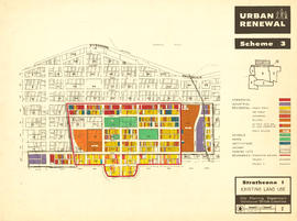
Map is a plan showing streets, blocks, lots and structures in the area just west of Main Street to just east of Glen Drive and from Burrard Inlet in the north to Prior Street in the south. The map is hand coloured to show the condition of residential buildings from very good to very poor in the area bounded by Main Street, Hastings Street, Glen Drive and Prior Street, based upon a 1957 field survey. Also included are the names of businesses along the waterfront.