Mt. Pleasant's Brewery Creek : urban study
- PUB-: PD 1358
- Item
- 1985
Part of City publications collection
134 results with digital objects Show results with digital objects
Mt. Pleasant's Brewery Creek : urban study
Part of City publications collection
Vancouver heritage resource inventory : phase I : technical report.
Part of City publications collection
Item is a map showing land use for single family, two family. and multiple family dwellings, tourist courts and cabins, hotels, offices and other commercial uses, stores, parking and commercial lots, service stations, warehouses and storage yards, light industrial, heavy industrial, public and semi-public buildings, public utilities, schools, open spaces, and railroads and docks.

City of Vancouver, British Columbia : 1981 census of Canada
Part of City publications collection
Item is a map showing 1981 census tracts and enumeration areas, and federal electoral districts.

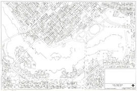
Downtown peninsula - Vancouver, B.C. : contour lines at 10 foot intervals, datum line - 100
Part of City publications collection
The Kitsilano neighbourhood plan : summary
Part of City publications collection
1989 aerial photograph key map
Part of City publications collection
Part of City publications collection

Strathcona (building outlines)
Part of City of Vancouver fonds
Item consists of a map depicting the outlines of buildings in the Strathcona neighbourhood.

Old Shaughnessy (building outlines)
Part of City of Vancouver fonds
Item consists of a map depicting the outlines of buildings in the portion of Shaughnessy north of King Edward Avenue.

Riley Park (building outlines)
Part of City of Vancouver fonds
Item consists of a map depicting the outlines of buildings in the Riley Park neighbourhood.

Mount Pleasant (east half; building outlines)
Part of City of Vancouver fonds
Item consists of a map depicting the outlines of buildings in the Mount Pleasant neighbourhood.

Mount Pleasant (west half; building outlines)
Part of City of Vancouver fonds
Item consists of a map depicting the outlines of buildings in the Mount Pleasant neighbourhood.
False Creek basin including building outlines
Part of City of Vancouver fonds
Item consists of a map depicting the outlines of buildings in the area surrounding False Creek, including the southern portions of Downtown and the northern portion of Fairview west to south Granville.

Kensington N.I.P area (building outlines)
Part of City of Vancouver fonds
Item consists of a map depicting the outlines of buildings in the Kensington neighbourhood and immediately adjacent areas.

Grandview-Woodland Local Area (building outlines)
Part of City of Vancouver fonds
Item consists of a map depicting the outlines of buildings in the Grandview-Woodland neighbourhood.

Part of City of Vancouver fonds
Item consists of a map depicting the outlines of buildings in the Fairview neighbourhood.

City of Vancouver. British Columbia (east half)
Part of City of Vancouver fonds
Item consists of a map depicting the city's streets and transportation infrastructure, including railways lines.

City of Vancouver. British Columbia (west half)
Part of City of Vancouver fonds
Item consists of a map depicting the city's streets and transportation infrastructure, including railways lines.

Part of City of Vancouver fonds
Item consists of a map depicting Vancouver's major road, the original Skytrain line and location of stations.
[Parking and gas stations : downtown]
Part of City of Vancouver fonds
File consists of four plans showing parking and gas stations in downtown Vancouver.
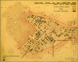
Parking lots in the downtown area
Part of City of Vancouver fonds
Item is a plan showing parking lots in the downtown area and indicating the type of surface treatment to the lots. Map is numbered Plan 4.
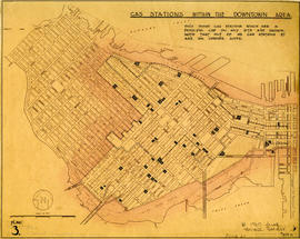
Gas stations within the downtown area
Part of City of Vancouver fonds
Item is a plan showing gas stations within the downtown area. A note on the map states that "only those gas stations which are a principal use on any site are shown. Note that out of 43 gas stations 37 are on corner sites." Map is numbered Plan 3.

Parking in existing and proposed designated parking areas, May 1960
Part of City of Vancouver fonds
Item is a plan showing parking in existing and proposed designated parking areas. Plan shows parking structures, parking lots with hourly and monthly rates, as well as private parking lots. Map is numbered Plan 2.

Parking within the existing (CM-2) and (C-5) zoning districts, June 1960
Part of City of Vancouver fonds
Item is a plan showing parking within CM-2 and C-5 zoning districts in downtown Vancouver. Plan shows parking structures and parking lots with and without screening and landscaping. A note on the map states "in these districts parking is only permitted conditional upon approval by City Council." Map is numbered Plan 1.

Figure 15 : a circulation pattern for pedestrians
Part of City of Vancouver fonds
Map is a plan of downtown Vancouver with areas shaded to indicate streets, squares, malls and arcades, in which the movement of vehicles is not permitted at all or is restricted. Although the entire downtown area is shown, shading pertains only to Jervis Street and Main Street and Burrard Inlet and Nelson Street. Note written in the bottom right corner of the map reads "B 1960 Jan., Traffic Plans, small folder."

Figure 12 : parking as the major use of land in 1976
Part of City of Vancouver fonds
Map is a plan of downtown Vancouver showing parking structures and parking lots in the area between Jervis Street and Main Street and Burrard Inlet and Nelson Street. The source of the map is indicated as 'parking supply and demand projections, September 1959'. Note written in the bottom right corner of the map reads "B 1960 Jan., Traffic Plans, small folder."

Figure 11 : parking as the major use of land in 1959
Part of City of Vancouver fonds
Map is a plan of downtown Vancouver showing parking structures and parking lots in the area between Jervis Street and Main Street and Burrard Inlet and Nelson Street. The source of the map is indicated as an aerial photograph taken April 1959. Note written in the bottom right corner of the map reads "B 1960 Jan., Traffic Plans, small folder."
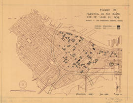
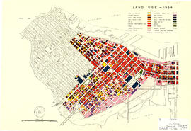
Figure 10 : parking as the major use of land in 1954
Part of City of Vancouver fonds
Map is a plan of downtown Vancouver showing parking structures and parking lots in the area between Jervis Street and Main Street and Burrard Inlet and Nelson Street. The source of the map is indicated as 'The Downtown Parking Report'. Note written in the bottom right corner of the map reads "B 1960 Jan., Traffic Plans, small folder."

Complete pedestrian mall : all traffic taken off : street closed
Part of City of Vancouver fonds
Item is consists of an architectural drawing showing three stages of development of a proposed pedestrian mall on Granville Street between Georgia Street and Dunsmuir Street. The pedestrian mall includes a sculpture fountain, sidewalk terraces (cafés), children's play area with merry-go-round, fish pool and fountain pool.

Pedestrian mall : looking south
Part of City of Vancouver fonds
Item is a drawing of a proposed pedestrian mall on Granville Street looking south from Dunsmuir Street. Shows pedestrians; the Vancouver Block, Birks Building and Hudson's Bay Building; shops, including Zellers, Raeson Shoes, Saba Brothers and Woolworth's; the Colonial Theatre; and an outdoor café.
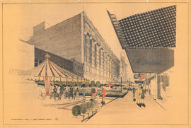
Pedestrian mall : view towards south
Part of City of Vancouver fonds
Item is a drawing of a proposed pedestrian mall on Granville Street looking south from about Dunsmuir Street. Shows pedestrians, the Vancouver Block, Birks Building, Hudson's Bay Building, shops, an outdoor café and a merry-go-round.

Part of City of Vancouver fonds
Map is a plan of the area bounded by Balsam Street, 3rd Avenue, Arbutus Street and Broadway, showing streets, blocks, lots and legal descriptions. Lots along Fourth Avenue are hand coloured to indicate the period of erection of the structures upon them. Also indicated are those buildings over one storey in height and buildings contructed of masonry. Plan is labelled " K, 1961 April, 3942B, small."
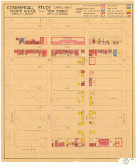
Part of City of Vancouver fonds
Map is a plan of the area bounded by Balsam Street, 3rd Avenue, Arbutus Street and Broadway, showing streets, blocks and some buildings. Structures are indicated on the plan for Yew Street between Fourth Avenue and Broadway and for Fourth Avenue, between Balsam and Arbutus Street. Structures are hand coloured to indicate land use, such as single family dwellings or business offices. Plan is labelled " K, 1961 April, 3941B, small."
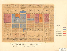
Government precinct : major land ownerships
Part of City of Vancouver fonds
Map is a plan of the area bounded by Oak Street, Broadway, Yukon Street and Sixteenth Avenue, showing streets, blocks, lots and legal descriptions. Map is hand coloured to show property owned by the City, Vancouver General Hospital, the Province of British Columbia, the B.C. Cancer Institute, and private owners within the 'Government Precinct' boundaries. Indicated are the locations of King Edward High School, Vancouver General Hospital, the Model School, Provincial Government building, City Hall, and a Refuge Home. Plan is labelled "G : 1960 March, 320-6A, Gov't Precinct 1957."
Industrial zoning : changes from 1930-1962
Part of City of Vancouver fonds
Map is Plan no. 4105A Sheet 10 of 11 of the City of Vancouver, showing streets, blocks, hospitals, golf courses, First Nations reserves, parks, schools, city yards and cemetery. Map is hand coloured to show light and heavy industry additions, light and heavy industry deletions, and changes from light to heavy industry and heavy to light industry. Base map is titled "City of Vancouver zoning map : a diagrammatic reproduction of schedule "D" : zoning district plan and schedule "E" : building lines of zoning and development by-law no. 3575 (amended to by-law no. 3972, March 1962)." Map is dated June 25, 1962 and labelled "1962 June 4105 A-10, Industrial Study 1964."
Part of City of Vancouver fonds
Map is Plan no. 4105A Sheet 8 of 11 of the City of Vancouver, showing streets, blocks, hospitals, golf courses, First Nations reserves, parks, schools, city yards and cemetery. Map is hand coloured to show designated routes, designated areas for different sizes of commercial vehicles, the central district and areas zoned for industry. Map is labelled "1963 4105 A-8 Industrial Study 1964." Base map is amended to May 1961.
Industry : parking : on street
Part of City of Vancouver fonds
Map is Plan no. 4105A Sheet 7 of 11 of the City of Vancouver, showing streets, blocks, hospitals, golf courses, First Nations reserves, parks, schools, city yards and cemetery. Map is hand coloured to show full parking, half parking, no parking and no parking allowed. Map is labelled "1964 April 4105 A-7 Industrial Study 1964." Base map is amended to May 1961.
Part of City of Vancouver fonds
Map is Plan no. 4105A Sheet 5 of 11 of the City of Vancouver, showing streets, blocks, hospitals, golf courses, First Nations reserves, parks, schools, city yards and cemetery. Map is hand coloured to show very good, good, fair, poor and very poor site quality. Base map is amended to May 1961.
Part of City of Vancouver fonds
Map is Plan no. 4105A Sheet 4 of 11 of the City of Vancouver, showing streets, blocks, hospitals, golf courses, First Nations reserves, parks, schools, city yards and cemetery. Map is hand coloured to show very good, good, fair, poor and very poor quality streets. Map is labelled "1963 January 4105 A-4 Industrial Study 1964." Map is dated January 1963 in the bottom left corner; base map is amended to May 1961.
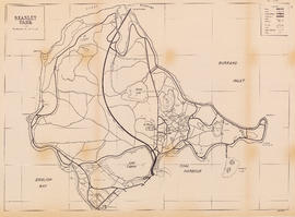
Part of City publications collection
Item is a map showing roads, trails, walkways, parking lots, buildings, shorelines, creeks, and swamps in Stanley Park.
Pattern language : Britannia Community Services Centre, index to first group of parts
Part of City publications collection

Marpole (east half; building outlines)
Part of City of Vancouver fonds
Item consists of a map depicting the outlines of buildings in the Marpole neighbourhood.

Marpole (west half; building outlines)
Part of City of Vancouver fonds
Item consists of a map depicting the outlines of buildings in the Marpole neighbourhood.
Kitsilano (east half; building outlines)
Part of City of Vancouver fonds
Item consists of a map depicting the outlines of buildings in the Kitsilano neighbourhood.
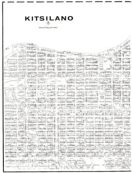
Kitsilano (west half; building outlines)
Part of City of Vancouver fonds
Item consists of a map depicting the outlines of buildings in the Kitsilano neighbourhood.

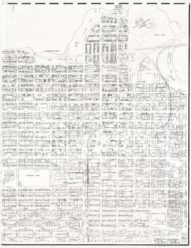
Part of City of Vancouver fonds
Item consists of a map depicting the outlines of buildings in the Downtown area of the city.
Participation - Vancouver City Planning Department
Part of City publications collection
Cabaret and restaurant guidelines
Part of City publications collection
Part of City publications collection
Page lists the following, with the bar graphs showing preparation phases and implementation time frames: redevelopment project no. 1, redevelopment project no. 2, FP 6 Raymur Place, urban renewal scheme no. 3, public housing (Blk. 56, D.L. 264A), public housing (A-3 & part of A-6), public housing (Blk. A, D.L. 730), part V N.H.A. study, urban renewal scheme no. 4, public housing related to scheme 4, urban renewal scheme no. 5, public housing related to scheme 5, urban renewal scheme no. 6, urban renewal scheme no. 7.