![[Vancouver Police force]](/uploads/r/null/c/b/cb46f056b409004677e2efed8bfc79acfec8ab8db1eb176b954123bc1135302e/a8745ae7-5955-4212-8384-11b0b2b7452f-A65069_142.jpg)
- VPD-S214-: CVA 480-365
- Item
- Apr. 1921
Panoramic group portrait
1696 results with digital objects Show results with digital objects
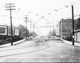
Panoramic group portrait

Looking north on Oak Street at West 16th Avenue
Part of City of Vancouver fonds
Photograph shows construction of the electric street railroad, businesses in the 3100 block Oak Street, Leo Service station (3095 Oak Steet), Huntly Lodge (3050 Oak Street), 3027 Oak Street and Athol Apartments (2970 Oak Street).

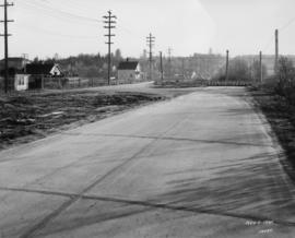
View looking north on Oak Street at West 15th Avenue
Part of City of Vancouver fonds
Photograph shows electrical lines, street light, the edge of Huntley Lodge (3050 Oak Street), houses at 3027, 3017, 3007 Oak Street and 1026 West 14th Avenue,Van Arsdel Apartments (2975 Oak Street) and Cleary Court Apartments (2925 Oak Street).
Looking south on Oak Street at West Broadway
Part of City of Vancouver fonds
Photograph shows overhead electrical lines, billboards, Vallejo Court Apartment building (1009 West 10th Avenue) and the north side of the Vancouver Jewish Community Centre (2675 Oak Street).
![[Photograph of a stoplight]](/uploads/r/null/7/4/74c224b383e1f94c182abad984ae1f2bf4ddfb3986b553762fdb976feabed022/fe00f732-37f2-4e7c-a3c1-f1ee5b245c8b-A43703_142.jpg)
Part of City of Vancouver fonds
![[Photograph of a stoplight]](/uploads/r/null/0/0/00e46d8380a39fb16ca7911ba995eb3d714b9477dab76e3de5807f7d1eddc65f/62994856-7cd6-450e-bbb5-5a8a896ad3b0-A43702_142.jpg)
Part of City of Vancouver fonds

Detail of the west side of Fraser, north of 67th Avenue
Part of City of Vancouver fonds

Wooden sidewalk on unidentified street
Part of City of Vancouver fonds

Wooden sidewalk on unidentified street
Part of City of Vancouver fonds

Sidewalk on Water Street west of Carrall
Part of City of Vancouver fonds

Great Northern tracks on Boundary Road
Part of City of Vancouver fonds
Great Northern tracks on Boundary Road
Part of City of Vancouver fonds

Looking east down Georgia viaduct
Part of City of Vancouver fonds
Photograph shows a sign reading, Street closed by order of City Engineer.

Looking east down Georgia viaduct
Part of City of Vancouver fonds
Photograph shows Marshall-Wells B.C. Limited on the left and the Empress Theatre in the distance.

Looking east along Cordova at Seymour
Part of City of Vancouver fonds
Photograph shows Nabob Brands Roasters & Importers of Extracts etc.

Looking south on Fraser near 67th Avenue
Part of City of Vancouver fonds
Photograph shows Webb's Shoe Repairs and a wooden sidewalk.

St. Francis Hotel and CPR Station, looking west down Cordova Street
Part of City of Vancouver fonds
![Convent [of the Sacred Heart School for Girls (later St. George's School)]](/uploads/r/null/a/8/a8dd94e0287ddd9d5d46856388e54d9a72605e4e4b96c8b6467e537daa7b8064/3a8ef464-f77e-46f8-81f7-99969648a3f5-A70549_142.jpg)
Convent [of the Sacred Heart School for Girls (later St. George's School)]
Part of St. George's School fonds
Ice Delivery Co. Ltd. Building
Part of Mitchell family fonds
![[West Coast Shipbuilders Limited site under construction]](/uploads/r/null/5/8/58584b679b854c84a8cf7c1e6055bea560dec1d0a2cf752433a1b0fd3fb81bc9/49c41e03-e2fc-4e14-8536-cdb7c3c3c4b4-A43339_142.jpg)
[West Coast Shipbuilders Limited site under construction]
Part of Major Matthews collection
Photograph shows the north side of False Creek and Downtown in the background
![[West Coast Shipbuilders Limited site under construction]](/uploads/r/null/6/b/6bd8531423cc7725255454dfacd90e23428f1607c16fcd6bd6a2159c2f93d758/9f561c65-24df-4552-af90-83054bdc67c1-A43338_142.jpg)
[West Coast Shipbuilders Limited site under construction]
Part of Major Matthews collection
Panoramic view showing part of the Hamilton Bridge (Western) Limited building, a gas storage silo and the Sun Tower in the background
![[Exterior of Hamilton Bridge (Western) Limited on False Creek]](/uploads/r/null/8/f/8fa1a250ff514eca96520a5961c3a36a766505bc2aebbdf03dc1630c348ec2a1/998ed617-01fe-4f28-96e3-c95fbabdad52-A43337_142.jpg)
[Exterior of Hamilton Bridge (Western) Limited on False Creek]
Part of Major Matthews collection
Panoramic view
![[Interior of Hamilton Bridge (Western) Limited on False Creek]](/uploads/r/null/6/2/6202aeb8b9d3ecbbb12d1276d7f835b5dc3cfd37d91d346e7f0e018f31dd8b42/56c925b1-4627-4b1c-b4f0-69224183b400-A43336_142.jpg)
[Interior of Hamilton Bridge (Western) Limited on False Creek]
Part of Major Matthews collection
![[Interior of Hamilton Bridge (Western) Limited on False Creek]](/uploads/r/null/0/d/0dd9359e5748c2076f4c9d4b3213fc18c183f3d476bb9759532d591043a8d1d7/8fc9eef3-33bb-45a9-a75c-03bcf6c99808-A43335_142.jpg)
[Interior of Hamilton Bridge (Western) Limited on False Creek]
Part of Major Matthews collection
![[Interior of Hamilton Bridge (Western) Limited on False Creek]](/uploads/r/null/4/0/4096a70292e34103613df5529fd13910760e836049b3d715b46989d28c288bbc/325624bc-ba75-4e76-8537-e4b330f19913-A43334_142.jpg)
[Interior of Hamilton Bridge (Western) Limited on False Creek]
Part of Major Matthews collection
![[View of C.P.R. Pier "D" from the roof of the Post Office]](/uploads/r/null/f/5/f51a0735cc0af724e55ece759cc3a31cecfae8aef85c8ec45ee034d883436adb/1f4dbe18-c176-4091-93a4-2dd471b14d4c-A43400_142.jpg)
[View of C.P.R. Pier "D" from the roof of the Post Office]
Part of Major Matthews collection
Photograph shows the "Princess Charlotte" and the "Empress of Australia"

Part of Major Matthews collection
![[View of C.P.R. Pier 'B' and Pier 'C' from the top of the Royal Bank building]](/uploads/r/null/a/4/a440e3398d4526c39cc8bbbb702aaead801062934f502f27f43e1d109216bf2b/935de5ec-0605-477f-b09a-c04c6b7abc38-A09922_142.jpg)
[View of C.P.R. Pier 'B' and Pier 'C' from the top of the Royal Bank building]
Part of Major Matthews collection
![[View of Howe Sound from West Vancouver]](/uploads/r/null/9/d/9d2d676791acb7b4fff2918d33c9775c7c2455f5135e567ce86d398fe7ec4a4e/5df6b8be-b0b3-4909-9d34-3d001797eea5-A09921_142.jpg)
[View of Howe Sound from West Vancouver]
Part of Major Matthews collection
![[View of Howe Sound from West Vancouver]](/uploads/r/null/4/e/4e434b4da0159b0f9ddcc19828bf72e262bf6d490874b5b2ff13bc89ca870a41/241ac1d5-a75f-44bb-87e5-0a9a8802d021-A09920_142.jpg)
[View of Howe Sound from West Vancouver]
Part of Major Matthews collection
![[View of Howe Sound from West Vancouver showing Hood Point on Bowen Island]](/uploads/r/null/9/5/95d669d485294908ad6ea6b5948509455b4c64f91677fe479440d28292d56bb4/b2ce2d6e-c24a-49ec-a4ac-da63d3417d65-A09919_142.jpg)
[View of Howe Sound from West Vancouver showing Hood Point on Bowen Island]
Part of Major Matthews collection
![[View of Howe Sound from West Vancouver showing Hood Point, Bowyer Island and Whytecliffe]](/uploads/r/null/6/7/67562932d73e81a1eb4649431864ce783f7c20df7f3d066a345c0d5240f3f4ea/c298f1e1-fb66-4e56-8bcb-11686ae38da7-A09918_142.jpg)
[View of Howe Sound from West Vancouver showing Hood Point, Bowyer Island and Whytecliffe]
Part of Major Matthews collection
![[Boathouse and beach at Whytecliffe Park]](/uploads/r/null/4/a/4ab5157172ffa04f4988311f35ad76a553712a5b9f3a00989bb315873a128501/ec6efeca-7965-481d-9931-78a27d632372-A09917_142.jpg)
[Boathouse and beach at Whytecliffe Park]
Part of Major Matthews collection
![[View of Whytecliffe Park]](/uploads/r/null/2/a/2a1167266653e4c46007bdba89d6be4d8fe66cce9792d145fbf3aa8fb1d75afc/8b9aa5a0-537d-46f1-8291-bea64192e255-A09916_142.jpg)
Part of Major Matthews collection
![[Whytecliffe Park pavilion]](/uploads/r/null/8/e/8ef52f39e4f7c5bbf6ae5f4c23a15dd73f457acb0181943f42c1a6003f2d6995/f00f3972-f989-4b1e-958b-97b4f79e96d8-A09915_142.jpg)
Part of Major Matthews collection
![[View of Larson Bay looking south toward Batchelor Point]](/uploads/r/null/b/1/b1f13b8d6c2c0c3cb96ae766a3b020f9022423e3244d6c98571e008ef63f1e1f/4bd56f08-19ff-418f-996d-341cdeee0fc7-A09914_142.jpg)
[View of Larson Bay looking south toward Batchelor Point]
Part of Major Matthews collection
![[View of Kettle and Batchelor Points and Garrow Bay from Whytecliffe Park]](/uploads/r/null/0/a/0a96bd2feaacdb3fe247826abf16686d8b9aaeeeeda3cdb006534c3f0c53b71c/1a9f3b2d-c1fb-4933-a666-ab87b5bf1532-A09913_142.jpg)
[View of Kettle and Batchelor Points and Garrow Bay from Whytecliffe Park]
Part of Major Matthews collection
J.S. Matthews' notes with print or negative in Archives.
![[Gleneagles Golf Course]](/uploads/r/null/1/2/12ebefdb7f5bd57b61da8b13d47ca1da9def9b8f25612b08899e400270f33953/d6a75ed1-ebd5-4f7e-bd3d-47cf674385ed-A09912_142.jpg)
Part of Major Matthews collection
![[Gleneagles Golf Course]](/uploads/r/null/d/a/da94714f5ae7f48f7d13d24b06946ced51a68001443a175ff04140df917e189c/2d245cd1-e82b-40c1-b187-6ae62a6e3249-A09911_142.jpg)
Part of Major Matthews collection
Photograph shows area, formerly part of Larson's Ranch.
![[Gleneagles Golf Course]](/uploads/r/null/d/4/d4d0e1fc68956df6eb61f767b03682c6bac7a324c42e60874f1d8e798ed15a45/ce4075ce-a8a5-413f-8374-b5cc0a6dd604-A09910_142.jpg)
Part of Major Matthews collection
Photograph shows area formerly part of Larson's Ranch.
![[Gleneagles Golf Course]](/uploads/r/null/1/4/14100a99e68e215d338cc12150f205f07a2cad5868207eabf19489a1651d3bc9/ca2ec0e2-b6a9-42d7-9618-fba456865755-A09909_142.jpg)
Part of Major Matthews collection
Photograph shows area, formerly part of Larson's Ranch.
![[Gleneagles Golf Course]](/uploads/r/null/8/0/80a93a183abeefe836fb487a95e23a7d11e83e6d9916ec202730c979832e13f9/278a3065-9bb9-450e-ba09-2c2fc0e42828-A09908_142.jpg)
Part of Major Matthews collection
Photograph shows area, formerly part of Larson's Ranch
![[Caretaker's cottage and stable at Larson's Ranch, Larson Bay]](/uploads/r/null/5/6/564b7e92727476d06c920c59321097ac2b08a64c9a3d00d3777d26478cb73696/14f2fb1c-2243-4cdb-b113-f23d21d5c906-A09907_142.jpg)
[Caretaker's cottage and stable at Larson's Ranch, Larson Bay]
Part of Major Matthews collection
![[Larson's Ranch at Larson Bay]](/uploads/r/null/2/f/2fff1d4d2960ea13039adcd6cf565c7b476154ea85e047e1f28f18c19ea3d428/54a05fdb-4a08-4ad3-860a-cc50b7dec6cb-A09906_142.jpg)
[Larson's Ranch at Larson Bay]
Part of Major Matthews collection
Photograph shows a boathouse on the beach with the caretaker's cottage, stables and ranch house visible above the bay.
![[Larson Bay]](/uploads/r/null/6/3/63cbe7af0fc5719c62ab9b3522327e7c7e651c44b1211d97b26d14373442eefd/91441935-7499-42a3-99ad-9aa664069f00-A09905_142.jpg)
Part of Major Matthews collection
![[Larson's Ranch at Larson Bay]](/uploads/r/null/c/1/c1024a71f97519b5aa252a4bbb863a833ec0a9e03917b4096255e8a03f9d378c/bd15e446-f0d2-49b8-a155-c25f6a90080b-A09904_142.jpg)
[Larson's Ranch at Larson Bay]
Part of Major Matthews collection
Photograph shows boathouse on the beach with the caretaker's cottage and ranchhouse visible above the bay.
![[Caretaker's cottage and stable at Larson's Ranch, Larson Bay]](/uploads/r/null/0/3/03e1d5de967ddc03ee79e65681f7d9c977014e284c447ce75c4571de407b9755/d65f3307-80bb-429e-8c82-d75f299aa89e-A09903_142.jpg)
[Caretaker's cottage and stable at Larson's Ranch, Larson Bay]
Part of Major Matthews collection
![[Thomas Garrow's house at Garrow Bay near Whytecliffe Park]](/uploads/r/null/4/9/49a49c4f0bf8b16b0f93bbce7455469888b46b0320ad9655c638b175fed8fd7e/10b37908-390d-4001-b360-c689e5101038-A09902_142.jpg)
[Thomas Garrow's house at Garrow Bay near Whytecliffe Park]
Part of Major Matthews collection
J.S. Matthews' notes with print or negative in Archives.
![[Entrance to Whytecliffe Park on Marine Drive above Batchelor Bay]](/uploads/r/null/c/4/c441051a7d56e18d0d5e15b8696b185d65a619fea84eaa7021777b04e5da5bc5/14fe946c-2293-4553-864f-03a99cbc9c66-A09901_142.jpg)
[Entrance to Whytecliffe Park on Marine Drive above Batchelor Bay]
Part of Major Matthews collection
![[Fisherman's Cove and Passage Island]](/uploads/r/null/a/1/a119ccfaf37b9076523c271a5be890b054a0c31d405ea13b3174c2cc2db87f68/672a9b2b-44aa-465c-bf52-b14d00a78028-A09900_142.jpg)
[Fisherman's Cove and Passage Island]
Part of Major Matthews collection
Photograph shows refreshment stand, dock and boats for hire at Fisherman's Cove with a view of Passage Island to the west. Construction of Marine Drive started in background.