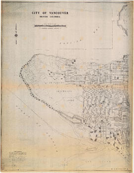
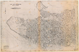
City of Vancouver, British Columbia : Point Grey to Cypress Street
- PUB-: PD 2111-: LEG1354.01
- Part
- 1981
Part of City publications collection
Part is the west half of a map of Vancouver showing streets, address block numbers, parks, schools, golf courses, First Nations reserves, railways, and topographic contour lines.


![City of Vancouver [park sites June/80]](/uploads/r/null/9/4/9484add7c4684ea3838e4d00ee8add3ecf85d78d5aa8fe2780cae273e59556a5/bd2464d8-2aa9-4501-aba6-8b3f7d130a42-MAP1032_142.jpg)


![[Sheet 6 : Nicola Street to Beatty Street and English Bay Beach to Georgia Street]](/uploads/r/null/f/2/f2effc97084427c0bd73bae3566d3ad910caaa6e7fb3e5ed9f3ece81bd2ac0a1/f2cc48a6-1195-4dd8-8227-71d36d1791bb-MAP339_142.jpg)
![[Sheet 5 : Stanley Park to Nicola Street and English Bay Beach to Robson Street]](/uploads/r/null/1/d/1daf1ff2196704e4e82a6b5c7476ee3e8a46b4e0740f3c37f3f58813f5f8b5f0/ee3a2706-4ebe-4ee8-b4db-da89840c7f89-MAP339_142.jpg)
![[Sheet 4 : Chilco Street to Burrard Street and Robson Street to Deadmans Island]](/uploads/r/null/9/4/9482209e02b8dc04c79ef404276e1d40bcbb4fab0330b4aa744e352ae9440921/5597738a-70b2-4cfc-a802-6a076987c33d-MAP339_142.jpg)


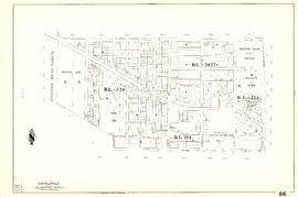
![[Sheet 88 : Macdonald Street to Angus Drive and Edgington Avenue to Fifty-seventh Avenue]](/uploads/r/null/5/9/595b991e091f624b5f74507db063dddb150624fbef03fe1d577f8d7a32bb9088/8afa1350-f31b-43bd-a14f-0ea9082c21fe-MAP339_142.jpg)
![[Sheet 87 : Barnard Street to Heather Street and Beckwith Road to Seventy-fifth Avenue]](/uploads/r/null/5/b/5b41d7f129096861b243317317db68bc0b54890dd82076ae972b78c504318686/01e0f65c-cd9d-4050-8861-1cafa29a58cc-MAP339_142.jpg)
![[Sheet 89 : North Arm of Fraser River to Southwest Marine Drive and Barnard Street]](/uploads/r/null/f/9/f98aff3ec8879da9a55c5b6dbe11a8bbc03439210831ff3b0cc884e0ac4bbcfd/ba8da922-1aaa-419f-93de-9658629a43b7-MAP339_142.jpg)
![[Sheet 83 : Fremlin Street to Main Street and Southwest Marine Drive to Fifty-seventh Avenue]](/uploads/r/null/3/e/3efc869894db6ec7c88cf96b10cd2cb7f93db04cae7e1f6f35be1ac51c2bdc14/6323fdeb-3ce2-4794-bc7f-691ce81ee431-MAP339_142.jpg)
![[Sheet 86 : Angus Drive to Laurel Street and Seventy-fifth Avenue to Sixty-seventh Avenue]](/uploads/r/null/6/e/6efd95dacdad7f8976575767597855d90ccaa34e423b1ba76885d33d2dffb725/8167b0a2-0792-4e60-9755-7a4706830df0-MAP339_142.jpg)
![[Sheet 85 : Laburnum Street to Fremlin Street and Sixty-eighth Avenue to Fifty-seventh Avenue]](/uploads/r/null/a/b/ab9f29b0e940cdcc4947062af96fb062d03e6ee1a34cac14d94b05edec4e2463/b9e1d243-5b38-4c67-ad11-2beba81bb35b-MAP339_142.jpg)


![[Sheet 81 : Main Street to Inverness Street and Southeast Marine Drive to Fifty-seventh Avenue]](/uploads/r/null/9/5/9518e71d1e1780cdb281e3519ba78f0606992747daac9a2701b7f7ff38a67a92/65136071-c971-4835-877a-159bf293b14d-MAP339_142.jpg)
![[Sheet 78 : Kerr Street to Ivy Avenue and North Arm of Fraser River to Southeast Marine Drive]](/uploads/r/null/9/0/90c6186a1aa17588ec162078d412440a826f55dc10a9d49f8e74df97a4d3ff6e/0a3e4f49-3d6d-4dec-95f1-08aa42e666d8-MAP339_142.jpg)
![[Sheet 79 : Gladstone Street to Kerr Street and North Arm of Fraser River to Bobolink Avenue]](/uploads/r/null/7/9/79214408afd85e4ab6ccc7eec43ecc85caf5ce5dedb9cfeb219866aa0091a733/7696de5a-3bba-4c2d-bc6c-83bf14bcf845-MAP339_142.jpg)
![[Sheet 72 : Oak Street to Quebec Street and Fifty-eighth Avenue to Forty-sixth Avenue]](/uploads/r/null/d/9/d95b8e85252fc5bb5a704534795819328aaac0251d8659e64190e79cd61b3037/43d93b13-ddc2-4f78-9ba2-07fbbcf3baa9-MAP339_142.jpg)
![[Sheet 75 : Nanaimo Street to Kerr Street and Bobolink Avenue to Forty-ninth Avenue]](/uploads/r/null/d/1/d14981939464fabe5e1b9488ecd26d62b3e16b1f4d1b8e00ece1bac6fa0dbdfa/a8e1d890-9726-473c-8f49-69d918d62d56-MAP339_142.jpg)