
- PUB-: PD 2103-: LEG1354.12
- Part
- 1990
Part of City publications collection
20 results with digital objects Show results with digital objects
Part of City publications collection

Part of City publications collection

Part of City publications collection

Part of City publications collection

Part of City publications collection

Part of City publications collection

Part of City publications collection

Part of City publications collection

City of Vancouver, B.C. area map : Inverness Street to Boundary Road and 32nd Avenue to 54th Avenue
Part of City publications collection

City of Vancouver, B.C. area map : Maple Street to Heatley Avenue and Burrard Inlet to 6th Avenue
Part of City publications collection

Part of City publications collection


City of Vancouver, British Columbia : Cypress Street to Boundary Road
Part of City publications collection
Part is the east half of a map of Vancouver showing streets, address block numbers, parks, schools, golf courses, First Nations reserves, railways, and topographic contour lines.
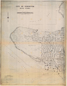
City of Vancouver, British Columbia : Point Grey to Cypress Street
Part of City publications collection
Part is the west half of a map of Vancouver showing streets, address block numbers, parks, schools, golf courses, First Nations reserves, railways, and topographic contour lines.

Part of City publications collection
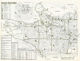
Part contains safety and security information for cyclists and a small map of major bikeways in Vancouver.

Part of City publications collection
Part contains safety and security information for cyclists and a small map of major bikeways in Vancouver.

Part of City publications collection
Part contains a map of Vancouver bicycle routes with a key to attractions, bridges and ferries, and downtown bicycle parking locations. An inset map shows Downtown Vancouver in more detail.

Part of City publications collection
Part contains a map of the north half of Vancouver (Burrard Inlet to 22nd Avenue) showing bicycle routes, parks, and SkyTrain stations, and textual information on downtown bicycle parking and combining cycling with public transit.
Part of City publications collection
Part contains a map of Vancouver bicycle routes with a key to attractions, bridges and ferries, and downtown bicycle parking locations. An inset map shows Downtown Vancouver in more detail.

Part of City publications collection
Part contains a map of the south half of Vancouver (22nd Avenue to the Fraser River) showing bicycle routes, parks, and SkyTrain stations, a list of useful contacts for cyclists, and information on bridges and connections.