
- AM1594-: MAP 1035
- Item
- 1979
Part of City of Vancouver Archives technical and cartographic drawing collection
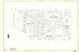
Map is a City Engineering Department base map of Vancouver, showing city blocks and Canadian Pacific, Canadian National and Great Northern Railway lines. Parks, golf courses, hospitals, schools, theatres and other structures are identified. "Metric Vancouver" and "Guide Map 15" appear in the bottom right corner of the map.

![City of Vancouver [park sites June/80]](/uploads/r/null/9/4/9484add7c4684ea3838e4d00ee8add3ecf85d78d5aa8fe2780cae273e59556a5/bd2464d8-2aa9-4501-aba6-8b3f7d130a42-MAP1032_142.jpg)


![[Sheet 6 : Nicola Street to Beatty Street and English Bay Beach to Georgia Street]](/uploads/r/null/f/2/f2effc97084427c0bd73bae3566d3ad910caaa6e7fb3e5ed9f3ece81bd2ac0a1/f2cc48a6-1195-4dd8-8227-71d36d1791bb-MAP339_142.jpg)
![[Sheet 5 : Stanley Park to Nicola Street and English Bay Beach to Robson Street]](/uploads/r/null/1/d/1daf1ff2196704e4e82a6b5c7476ee3e8a46b4e0740f3c37f3f58813f5f8b5f0/ee3a2706-4ebe-4ee8-b4db-da89840c7f89-MAP339_142.jpg)
![[Sheet 4 : Chilco Street to Burrard Street and Robson Street to Deadmans Island]](/uploads/r/null/9/4/9482209e02b8dc04c79ef404276e1d40bcbb4fab0330b4aa744e352ae9440921/5597738a-70b2-4cfc-a802-6a076987c33d-MAP339_142.jpg)


![[Sheet 88 : Macdonald Street to Angus Drive and Edgington Avenue to Fifty-seventh Avenue]](/uploads/r/null/5/9/595b991e091f624b5f74507db063dddb150624fbef03fe1d577f8d7a32bb9088/8afa1350-f31b-43bd-a14f-0ea9082c21fe-MAP339_142.jpg)
![[Sheet 87 : Barnard Street to Heather Street and Beckwith Road to Seventy-fifth Avenue]](/uploads/r/null/5/b/5b41d7f129096861b243317317db68bc0b54890dd82076ae972b78c504318686/01e0f65c-cd9d-4050-8861-1cafa29a58cc-MAP339_142.jpg)
![[Sheet 89 : North Arm of Fraser River to Southwest Marine Drive and Barnard Street]](/uploads/r/null/f/9/f98aff3ec8879da9a55c5b6dbe11a8bbc03439210831ff3b0cc884e0ac4bbcfd/ba8da922-1aaa-419f-93de-9658629a43b7-MAP339_142.jpg)
![[Sheet 83 : Fremlin Street to Main Street and Southwest Marine Drive to Fifty-seventh Avenue]](/uploads/r/null/3/e/3efc869894db6ec7c88cf96b10cd2cb7f93db04cae7e1f6f35be1ac51c2bdc14/6323fdeb-3ce2-4794-bc7f-691ce81ee431-MAP339_142.jpg)
![[Sheet 86 : Angus Drive to Laurel Street and Seventy-fifth Avenue to Sixty-seventh Avenue]](/uploads/r/null/6/e/6efd95dacdad7f8976575767597855d90ccaa34e423b1ba76885d33d2dffb725/8167b0a2-0792-4e60-9755-7a4706830df0-MAP339_142.jpg)
![[Sheet 85 : Laburnum Street to Fremlin Street and Sixty-eighth Avenue to Fifty-seventh Avenue]](/uploads/r/null/a/b/ab9f29b0e940cdcc4947062af96fb062d03e6ee1a34cac14d94b05edec4e2463/b9e1d243-5b38-4c67-ad11-2beba81bb35b-MAP339_142.jpg)


![[Sheet 81 : Main Street to Inverness Street and Southeast Marine Drive to Fifty-seventh Avenue]](/uploads/r/null/9/5/9518e71d1e1780cdb281e3519ba78f0606992747daac9a2701b7f7ff38a67a92/65136071-c971-4835-877a-159bf293b14d-MAP339_142.jpg)
![[Sheet 78 : Kerr Street to Ivy Avenue and North Arm of Fraser River to Southeast Marine Drive]](/uploads/r/null/9/0/90c6186a1aa17588ec162078d412440a826f55dc10a9d49f8e74df97a4d3ff6e/0a3e4f49-3d6d-4dec-95f1-08aa42e666d8-MAP339_142.jpg)
![[Sheet 79 : Gladstone Street to Kerr Street and North Arm of Fraser River to Bobolink Avenue]](/uploads/r/null/7/9/79214408afd85e4ab6ccc7eec43ecc85caf5ce5dedb9cfeb219866aa0091a733/7696de5a-3bba-4c2d-bc6c-83bf14bcf845-MAP339_142.jpg)
![[Sheet 72 : Oak Street to Quebec Street and Fifty-eighth Avenue to Forty-sixth Avenue]](/uploads/r/null/d/9/d95b8e85252fc5bb5a704534795819328aaac0251d8659e64190e79cd61b3037/43d93b13-ddc2-4f78-9ba2-07fbbcf3baa9-MAP339_142.jpg)
![[Sheet 75 : Nanaimo Street to Kerr Street and Bobolink Avenue to Forty-ninth Avenue]](/uploads/r/null/d/1/d14981939464fabe5e1b9488ecd26d62b3e16b1f4d1b8e00ece1bac6fa0dbdfa/a8e1d890-9726-473c-8f49-69d918d62d56-MAP339_142.jpg)


![[Sheet 65 : Camosun Street to Carnarvon Street and Forty-first Avenue to Thirty-third Avenue]](/uploads/r/null/4/0/407c98f21cf3d2ce519b79e8a505fd6a325c965dc1550cdbc00d96b7bc7e5e3d/04862e6e-5125-4593-84de-c80135fd76ce-MAP339_142.jpg)
![[Sheet 63 : Carnarvon Street to Cypress Street and Forty-first Avenue to Thirty-third Avenue]](/uploads/r/null/4/3/43f21afad72cf7d769c23be0a8b778e288335df1801a3b9d42bace4e74c8ea1a/64b6fa50-ede8-4087-81fc-6b7da9b7dfd1-MAP339_142.jpg)
![[Sheet 64 : Balaclava Street to Cypress Street and Forty-ninth Avenue to Forty-first Avenue]](/uploads/r/null/6/d/6d41bb5db0383d13fdc92e51638fb1e2c9ac8e11a664fd9070ee16be3212d8f5/07989ba9-42ff-4d9a-ac56-a25405a93120-MAP339_142.jpg)
![[Sheet 62 : Cypress Street to Oak Street and Forty-ninth Avenue to Forty-first Avenue]](/uploads/r/null/7/c/7c5b951f94dee2cfd6a1b82979539f15bd77424ef36377f8e2db0e7bfb4aae10/78c561eb-987a-4aef-9574-18f261df2111-MAP339_142.jpg)
![[Sheet 60 : Oak Street to Quebec Street and Forty-sixth Avenue to Thirty-seventh Avenue]](/uploads/r/null/b/5/b5e1b3fe1dda55eb9d0029fcbe47cb6048a48720c1ad1f7b1897640d35203319/e097b4d6-7a5c-41bc-9ca5-1b9e7b57eccc-MAP339_142.jpg)
![[Sheet 61 : Cypress Street to Oak Street and Forty-first Avenue to Thirty-third Avenue]](/uploads/r/null/e/c/ecb192d35087c4f7d7713e1578ae0bc7f934c92ab822401e070cf7a4cf61fdf3/1cfa7241-9da6-4626-aedb-d6bfa44f7d5e-MAP339_142.jpg)
![[Sheet 58 : Inverness Street to Nanaimo Street and Forty-ninth Avenue to Forty-first Avenue]](/uploads/r/null/5/5/55825f5529a2ab4a1b9c04e6d086f342c86830cc9828262a5f7b22eab255b346/4ce8baf7-a89b-4c24-bec2-d1a45477ca67-MAP339_142.jpg)
![[Sheet 59 : Quebec Street to Inverness Street and Forty-seventh Avenue to Thirty-seventh Avenue]](/uploads/r/null/0/1/015bc0f349dc1228105d4cdd774354b22820bad860e0a822b707d62c3eb343f5/b9fe9076-66e5-4167-b081-e65e8b625778-MAP339_142.jpg)
![[Sheet 56 : Doman Street and Joyce Street to Boundary Road and Forty-ninth Avenue to Kingsway]](/uploads/r/null/5/e/5ee0f6b78ce9f3b0e0e39795d6220cd37d587872bad7b41b67f4d29c7cb49d4c/f8a321d6-ea4f-4e1f-85da-6d12e149ea85-MAP339_142.jpg)


![[Sheet 53 : Inverness Street to Nanaimo Street and Forty-first Avenue to Thirty-second Avenue]](/uploads/r/null/a/9/a9fdfc1181cd3a36ad078c24a5892d8bfc60c5456733839fa59914d5700e6509/5f8f4fc4-26e4-49f3-b5d4-acced16d8490-MAP339_142.jpg)

![[Sheet 47 : Camosun Street to Blenheim Street and Thirty-third Avenue to King Edward Avenue]](/uploads/r/null/5/9/59c6b01a85dc6051f7cfecf1f33eb7e7017beb24d0dd57b512fcddc2063e3e8f/eabe5a9f-362b-46a4-9efc-275f9b96459b-MAP339_142.jpg)
![[Sheet 50 : Oak Street to Ontario Street and Thirty-seventh Avenue to Twenty-eighth Avenue]](/uploads/r/null/a/3/a3b7d0414ced2d15d401c5747a576809010cc56bb00c564251adecdb35091358/01957154-6807-4889-bc0f-a1f2455ab066-MAP339_142.jpg)
![[Sheet 45 : Discovery Street to Blenheim Street and King Edward Avenue to Fourteenth Avenue]](/uploads/r/null/7/b/7b9edfc2a053f0ba6c95af404ad3bf4f22a5e63ff6ddcd9acea2fd6dc469d916/ef5279fc-e406-412e-9886-eddb46d44c27-MAP339_142.jpg)
![[Sheet 46 : Blanca Street to Discovery Street and Sixteenth Avenue to Fourteenth Avenue]](/uploads/r/null/9/0/90f542cbf378be4c0b5366f96f6c5575e76ea3a215a1d517a5c1b7c12ca2425c/8324fff9-cff3-4306-89c6-e6157d1e36a0-MAP339_142.jpg)
![[Sheet 43 : East Boulevard to Oak Street and Laurier Avenue to Fourteenth Avenue]](/uploads/r/null/8/8/8846e3e6c19438103b656786c264d5dcccc37b59de3cf8fa85bb05f01b65d8f9/9fb3d6cb-93e9-48d0-be52-05cc55ad4ec4-MAP339_142.jpg)
![[Sheet 44 : Blenheim Street to Arbutus Street and King Edward Avenue to Fourteenth Avenue]](/uploads/r/null/2/f/2fdf5060ec6fdc47756dc75416312dd42047abea2beed2d99f086c73bd0c8726/2fe0f45d-ad6c-46e6-9a9f-50c795523f5f-MAP339_142.jpg)
![[Sheet 40 : Inverness Street to Nanaimo Street and Twenty-second Avenue to Thirteenth Avenue]](/uploads/r/null/9/3/9367a0c50f6fa513d717a1972b1bac72acde6d41b002fefcf48ddbd8c8122e8a/c7bfac0b-bf44-441b-b059-fd7bbc0bd4a0-MAP339_142.jpg)
![[Sheet 41 : Ontario Street to Inverness Street and Twenty-eighth Avenue to Sixteenth Avenue]](/uploads/r/null/c/2/c22ca2538905633f64373261ce970df6216075ce4de9e22d491c2e212ce17c1f/616ab944-e39a-4c66-abb4-918b17cc3252-MAP339_142.jpg)
![[Sheet 39 : Kingsway and Nanaimo Street to Rupert Street and Ward Street to Twenty-second Avenue]](/uploads/r/null/0/4/0409c276b1c046750a9680e1310ce46ec18fce0f1dfc928aab80fbe273730918/665972e9-723b-462b-b30f-95f1484b2c51-MAP339_142.jpg)
![[Sheet 42 : Oak Street to Ontario Street and Twenty-eighth Avenue to Sixteenth Avenue]](/uploads/r/null/c/7/c7489c984c3ec99abcbb22a87a294856654f9c25046416db253386367e8f4001/9f397dcd-244e-47bf-8acc-e4ae1dcd8a0d-MAP339_142.jpg)