Showing 22 results

Archival description
City of Vancouver Archives technical and cartographic drawing collection Canada. Canadian Hydrographic Service With digital objects
Print preview View:
Tidal current charts, Vancouver Harbour, British Columbia : front cover
Tidal current charts, Vancouver Harbour : inside front cover
Tidal current chart, Vancouver Harbour : inside back cover
Tidal current chart, Vancouver Harbour : one hour before maximum ebb at First Narrows
Tidal current chart, Vancouver Harbour : two hours before maximum ebb at First Narrows
Tidal current chart, Vancouver Harbour : maximum ebb at First Narrows
Tidal current chart, Vancouver Harbour : three hours after maximum ebb at First Narrows
Tidal current chart, Vancouver Harbour : one hour after maximum ebb at First Narrows
Tidal current chart, Vancouver Harbour : two hours after maximum ebb at First Narrows
Tidal current chart, Vancouver Harbour : one hour before maximum flood at First Narrows
Tidal current chart, Vancouver Harbour : two hours before maximum flood at First Narrows
Tidal current chart, Vancouver Harbour : maximum flood at First Narrows
Tidal current chart, Vancouver Harbour : one hour after maximum flood at First Narrows
Tidal current chart, Vancouver Harbour : two hours after maximum flood at First Narrows
Tidal current chart, Vancouver Harbour : three hours after maximum flood at First Narrows
Vancouver Harbour : Sheet 3 (Second Narrows to Port Moody)
Howe Sound and Howe Sound (southern portion)
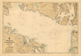
Sand Heads to Ballenas Islands
Vancouver Harbour : Sheet 1 (First Narrows to Second Narrows)
Vancouver Harbour : Sheet 2 (Point Grey to Second Narrows)
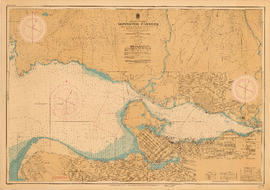
Vancouver North. British Columbia
Vancouver Harbour : Sheet 2 (Point Grey to Second Narrows)