Item is a topographical map showing the eastern portion of Sechelt Peninsula, Keats Island, southern portion of Gambier Island, Bowen Island, West Vancouver, North Vancouver, and Vancouver. City streets and blocks are shown, as well as surveyed parcels of land. Map also shows depth contours in fathoms for Howe Sound and Burrard Inlet.
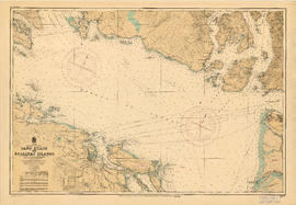
Item is a nautical chart of the Strait of Georgia and the southern portion of Howe Sound. Shows soundings in fathoms, tidal information, bench marks, locations of cables, and characteristics of land at shorelines.
Item contains two nautical charts of Howe Sound; one chart shows the southern portion (Bowen Island and Gambier Island) only, while the other shows the Sound from Burrard Inlet in the south to Squamish in the north. Charts show soundings in fathoms, tidal information, bench marks, locations of cables, and characteristics of land at shorelines.