British Columbia pilot. 1st - 7th ed.
- VK 945 .C3
- 1930
22 results with digital objects Show results with digital objects
British Columbia pilot. 1st - 7th ed.

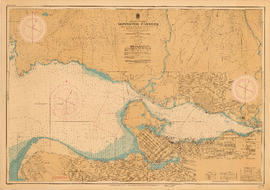
Howe Sound and Howe Sound (southern portion)
Part of City of Vancouver Archives technical and cartographic drawing collection
Item contains two nautical charts of Howe Sound; one chart shows the southern portion (Bowen Island and Gambier Island) only, while the other shows the Sound from Burrard Inlet in the south to Squamish in the north. Charts show soundings in fathoms, tidal information, bench marks, locations of cables, and characteristics of land at shorelines.
Office consolidation of the migratory birds convention act? and the migratory birds regulations
Pacific coast tide and current tables 1957
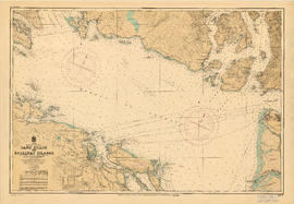
Sand Heads to Ballenas Islands
Part of City of Vancouver Archives technical and cartographic drawing collection
Item is a nautical chart of the Strait of Georgia and the southern portion of Howe Sound. Shows soundings in fathoms, tidal information, bench marks, locations of cables, and characteristics of land at shorelines.
The history of hydrographic surveying in British Columbia

Tidal current chart, Vancouver Harbour : inside back cover
Part of City of Vancouver Archives technical and cartographic drawing collection
Part contains information about the survey data upon which the charts are based, and contact information for the Canadian Hydrographic Service.

Tidal current chart, Vancouver Harbour : maximum ebb at First Narrows
Part of City of Vancouver Archives technical and cartographic drawing collection

Tidal current chart, Vancouver Harbour : maximum flood at First Narrows
Part of City of Vancouver Archives technical and cartographic drawing collection

Tidal current chart, Vancouver Harbour : one hour after maximum ebb at First Narrows
Part of City of Vancouver Archives technical and cartographic drawing collection

Tidal current chart, Vancouver Harbour : one hour after maximum flood at First Narrows
Part of City of Vancouver Archives technical and cartographic drawing collection

Tidal current chart, Vancouver Harbour : one hour before maximum ebb at First Narrows
Part of City of Vancouver Archives technical and cartographic drawing collection

Tidal current chart, Vancouver Harbour : one hour before maximum flood at First Narrows
Part of City of Vancouver Archives technical and cartographic drawing collection

Tidal current chart, Vancouver Harbour : three hours after maximum ebb at First Narrows
Part of City of Vancouver Archives technical and cartographic drawing collection

Tidal current chart, Vancouver Harbour : three hours after maximum flood at First Narrows
Part of City of Vancouver Archives technical and cartographic drawing collection

Tidal current chart, Vancouver Harbour : two hours after maximum ebb at First Narrows
Part of City of Vancouver Archives technical and cartographic drawing collection

Tidal current chart, Vancouver Harbour : two hours after maximum flood at First Narrows
Part of City of Vancouver Archives technical and cartographic drawing collection

Tidal current chart, Vancouver Harbour : two hours before maximum ebb at First Narrows
Part of City of Vancouver Archives technical and cartographic drawing collection

Tidal current chart, Vancouver Harbour : two hours before maximum flood at First Narrows
Part of City of Vancouver Archives technical and cartographic drawing collection
Tidal current charts : Vancouver Harbour, British Columbia
Part of City of Vancouver Archives technical and cartographic drawing collection
Item is a booklet containing twelve charts showing tidal currents in Vancouver Harbour at different points in the tidal cycle.

Tidal current charts, Vancouver Harbour : inside front cover
Part of City of Vancouver Archives technical and cartographic drawing collection
Part contains explanatory text to be used in conjunction with the tidal current charts in the booklet.
Tidal current charts, Vancouver harbour, British Columbia
Part of Major Matthews collection
File consists of a volume of nautical charts depicting direction and velocity of tides into and out of Vancouver harbour (Burrard Inlet) and around English Bay at various times of the day.

Tidal current charts, Vancouver Harbour, British Columbia : front cover
Part of City of Vancouver Archives technical and cartographic drawing collection

Vancouver Harbour : Sheet 1 (First Narrows to Second Narrows)
Part of City of Vancouver Archives technical and cartographic drawing collection
Item is a nautical chart of Vancouver Harbour from First Narrows in the west to Second Narrows in the east, showing soundings in fathoms, tidal information, anchorages, beacons, and waterfront businesses. Street names are shown on land areas.
Vancouver Harbour : Sheet 1 (First Narrows to Second Narrows)
Part of City of Vancouver Archives technical and cartographic drawing collection
Vancouver Harbour : Sheet 2 (Point Grey to Second Narrows)
Part of City of Vancouver Archives technical and cartographic drawing collection
Vancouver Harbour : Sheet 2 (Point Grey to Second Narrows)
Part of City of Vancouver Archives technical and cartographic drawing collection
Item is a nautical chart of Burrard Inlet and Vancouver Harbour from Point Grey in the west to Second Narrows in the east, showing soundings in fathoms, tidal information, anchorages, beacons, and waterfront businesses.

Vancouver Harbour : Sheet 2 (Point Grey to Second Narrows)
Part of City of Vancouver Archives technical and cartographic drawing collection
item is a nautical chart of Burrard Inlet and Vancouver Harbour from Point Grey in the west to Second Narrows in the east, showing soundings in fathoms, tidal information, anchorages, beacons, and waterfront businesses. Street names are shown on land areas. A Royal Canadian Air Force bombing range at Jericho Beach is identified as a danger area.
Vancouver Harbour : Sheet 3 (Second Narrows to Port Moody)
Part of City of Vancouver Archives technical and cartographic drawing collection

Vancouver Harbour : Sheet 3 (Second Narrows to Port Moody)
Part of City of Vancouver Archives technical and cartographic drawing collection
Item is a nautical chart of Vancouver Harbour from Second Narrows in the west to Port Moody in the east, showing soundings in fathoms, tidal information, anchorages, beacons, and waterfront businesses. Street names are shown on land areas.
Vancouver Harbour [nautical charts]
Part of City of Vancouver Archives technical and cartographic drawing collection
File consists of three published nautical charts which, collectively, map the entirety of Vancouver Harbour from Point Grey to Port Moody and the southern portions of Indian Arm.
The charts depict shorelines and shoreline development, sounding, underwater cables and pipes, shoals and other impediments to navigation, signals and beacons, land-based transportation infrastructure such as bridges and rail lines, tidal marshes, offshore anchorages and currents.

Vancouver North. British Columbia
Part of City of Vancouver Archives technical and cartographic drawing collection
Item is a topographical map showing the eastern portion of Sechelt Peninsula, Keats Island, southern portion of Gambier Island, Bowen Island, West Vancouver, North Vancouver, and Vancouver. City streets and blocks are shown, as well as surveyed parcels of land. Map also shows depth contours in fathoms for Howe Sound and Burrard Inlet.