General Key of Atlas/Title Page
- AM1594-MAP 342a-: MAP 342a.01
- Item
- July 1912
Part of City of Vancouver Archives technical and cartographic drawing collection
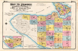
Item is a map which acts as a key to the volumes of the Atlas, depicting which areas are included in which volume. The map is incorporated in the title page of the volume.
![Plate 2: Waterfront [Granville Street - Burrard Inlet - Bute Street - Seaton/Hastings Street]](/uploads/r/null/e/e/6/ee607ca30e67c8c4896ae282b486b3f964d1df0e69215deb0cd511d30ed9192a/b8527682-9fa1-4aaa-8021-5885b6e2d810-MAP342a_142.jpg)
![Plate 3: Waterfront [Carrall Street - Burrard Inlet - Granville Street - Hastings Street]](/uploads/r/null/c/c/7/cc70d1a765eb2a68965a4c4b627827d53b432cd88d1d50e51081c4b205e112a8/1a6b5b79-2499-48c3-a96f-26eb2ca6444c-MAP342a_142.jpg)
![Plate 4: Waterfront Bute Street - Burrard Inlet - Bidwell Street - Georgia Street]](/uploads/r/null/5/6/e/56e493b1b8b9ebd5e77bae9be83741618c7d3b1c1b6a2992e4b6ef5edac7e16b/6eed9ed2-73a1-44f2-9e37-165d726d7fcb-MAP342a_142.jpg)
![Plate 5: West End [Richards Street - Hastings Street - Thurlow Street - Georgia Street]](/uploads/r/null/6/e/8/6e8029e15299600c6890f41cb1e769ea5f4c8a79c7923ef6e2075a19883197b7/ae297304-5960-4a77-930f-8a2926cc0ee0-MAP342a_142.jpg)
![Plate 6: Downtown [False Creek - Hastings Street - Richards Street - Georgia Street]](/uploads/r/null/d/d/b/ddbaf20b087e86cf7d4207d5d35455b0b7bf77324a6df070a9adb2a0bc587ecf/fa347988-8e1f-4026-b6f3-3901fc6f102b-MAP342a_142.jpg)
![Plate 7: West End [Cardero Street - Burrard Inlet - Coal Harbour/Park Road - Barclay Street]](/uploads/r/null/7/c/9/7c9620050dee0e734bfff1e37ce6e2e0affd0b3c0b799447714657aae517ae79/4b20302f-dc29-4512-858d-5524b7a4467f-MAP342a_142.jpg)
![Plate 8: West End [Cardero Street - Barclay Street - Park Road - Beach Avenue - Davie Street]](/uploads/r/null/6/d/6/6d680461017be540974f2eb8ba9641e6ea703be5860e413e63fdfe34f65ceead/e073c970-9088-45fe-8202-64066fbe2941-MAP342a_142.jpg)
![Plate 9: West End [Thurlow Street - Georgia Street - Cardero Street - Nelson Street]](/uploads/r/null/1/9/b/19b3fe0eae79817485533a75436377555fcbfd19e4603d5072d4b4f96c5c3a32/fd60c8fe-f7b1-4e31-805a-515a9c9bccb9-MAP342a_142.jpg)
![Plate 10: West End [Thurlow Street - Nelson Street - Cardero Street - Burnaby Street]](/uploads/r/null/e/b/2/eb281da970ebd644483c0c62bac6df4efa77211537470a4acc06ddf0dfdfca64/aee7ff8d-629b-4876-aa73-91222025ab9b-MAP342a_142.jpg)
![Plate 11: Downtown [Homer Street - Georgia Street - Thurlow Street - Burnaby Street/Drake Street]](/uploads/r/null/5/b/d/5bdf92b6d2c774df0db66b41942f3eacb7f3ac265aeefeac99ba2fe6be2377b8/42419aa4-f47a-47ec-870b-3fdab1496d88-MAP342a_142.jpg)
![Plate 12: Downtown [Homer Street - Nelson Street - Thurlow Street - Burnaby/Drake Street]](/uploads/r/null/c/4/7/c479046ad281d3e8c73d530cdea1a11c67c9851532d39090f74a7aeb902254c9/b6eac841-0ece-4d40-abef-04b5187d1ed7-MAP342a_142.jpg)
![Plate 13: West End [False Creek - Georgia Street - Homer Street - Nelson Street]](/uploads/r/null/9/d/4/9d42140eaeed380dcafc9d9f2ec4c75ff8838b865768cfc3a3265748ec5e28c6/c274bed5-3f86-4ff0-9a71-2e86ff6884c3-MAP342a_142.jpg)
![Plate 15: West End [Broughton Street - Burnaby Street/Davie Street - Denman Street - False Creek]](/uploads/r/null/1/3/0/13083b6fde232491e843c0bb62a3e683ea30651590e365309e8d1f17429acfa1/edde3573-9350-4c2b-8fee-5ac5e153d498-MAP342a_142.jpg)
![Plate 16: West End [Burrard Street - Burnaby Street - Broughton Street - False Creek]](/uploads/r/null/a/e/4/ae4a56ddc4cdf97482012768325293cc1d68ad0a5f115f88f04f5275ddf4c692/6df39ba5-4b67-4a21-9d2c-64e0f75b8726-MAP342a_142.jpg)
![Plate 17: West End [False Creek/CPR yards - Drake Street - Burrard Street - False Creek]](/uploads/r/null/6/7/3/673cc6c2e73aac364d594828685a373c4c21e3472090c2f42f66c52e1f4017b7/3e200741-7cad-4e20-852a-40b7b2cbef17-MAP342a_142.jpg)
![Plate 18: Kitsilano [Granville Street/False Creek - English Bay - Vine Street - Fourth Avenue]](/uploads/r/null/8/4/7/84793377156dc5b2cee4d0a61c1a42ba7d06bf59277c2ade519654c642d016df/c1ac7e98-80d1-43fc-a70e-7e6dc4fef11a-MAP342a_142.jpg)
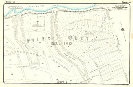
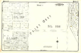
![Plate 19: Point Grey [DL 176 - English Bay - Blanca Drive - Sixth Avenue]](/uploads/r/null/9/0/9/909403abc0abc4ea9b01b1fe9828873551fc26e82dc2e7e8f84af526c1a137b6/34b7af86-7d81-4ed5-9c84-a350059fc9b2-MAP342a_142.jpg)
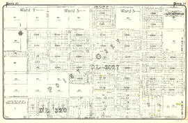
![Plate 20: Point Grey [Crown Street - Sixth Avenue - Blanca Drive - Sixteenth Avenue]](/uploads/r/null/e/7/1/e7131a5080595ea160953fc209124d18fa23d64a87bff5a9e09a0f0548c21440/2ad33d97-773a-48a1-935e-20d3599a75b0-MAP342a_142.jpg)
![Plate 21: Kitsilano Carnarvon Street - English Bay - Crown Street - Tenth Avenue]](/uploads/r/null/4/2/8/428f96578655c794d997e5a6ff5007ddbcabb876cb06f8aec6efe8db1ca589dc/d66a7b24-0eaa-47f3-bfa5-0a39a8ee9943-MAP342a_142.jpg)
![Plate 22: Kitsilano [Maple Street - English Bay - Bayswater Street - Eighth Avenue]](/uploads/r/null/9/d/9/9d9051a341addd66a3787edec21c3f030078f93d6880678e9cdafe7df84f7ef3/e6465a0a-12da-48fb-b10f-425350c425b0-MAP342a_142.jpg)
![Plate 23: Kitsilano [Carnarvon Street - Tenth Avenue - Crown Street - Twenty-first Avenue]](/uploads/r/null/c/b/9/cb9d797daebe3c23cc3ba0e3ab52ab602fa9dc4a36711e52ea66b2f98545e1ba/5287ebc9-ddb6-4554-a8ca-501a8cdcfd50-MAP342a_142.jpg)
![Plate 24: Kitsilano [Maple Street - Eighth Avenue - Carnarvon Street - Nineteenth Avenue]](/uploads/r/null/b/a/0/ba0d68b19000d99c14b892626e97bedc7f45445a348eb8777d39028478ac4859/2cc1981f-874e-400e-9af5-afe630d81ebd-MAP342a_142.jpg)
![Plate 25: Fairview [Oak Street - False Creek - Fourth Avenue - Cypress Street]](/uploads/r/null/2/7/2/2726be0d8aa2ac0291e1b47b1349d50e381b1f9dec983a5584305f99303e4b0b/dba924f1-ac60-4a66-ba3e-98b7efd7357d-MAP342a_142.jpg)
![Plate 26: Fairview [Ontario Street - False Creek - Oak Street - Broadway/Ninth Avenue]](/uploads/r/null/9/c/f/9cf0028638ea04ddd006a3c088b61627f8c0e4d4b5e18682e311f1d6def04d28/f9c5d29c-3cc9-4177-b843-0d5b612020da-MAP342a_142.jpg)

![Plate 28: Fairview [Ontario Street - Broadway/Ninth Avenue - Oak Street - Nineteenth Avenue]](/uploads/r/null/7/e/6/7e62aa80c58481466edbc9d0d7b745c557d25fdf62d02e52fa8c3f1cf37aff45/4bea1d2d-ba54-43ec-a23e-ba0cbb34f094-MAP342a_142.jpg)
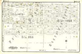
![Plate 29: Point Grey [Carnarvon Street - Twenty-first Avenue - Camosun Street - Thirty-first Avenue]](/uploads/r/null/3/6/d/36d64967233ead79fd5a60377f3c5e17df446e8fb639b21ee7558cddfd00f3ab/d5368109-f547-4d50-8e11-9e2ddea49dec-MAP342a_142.jpg)


![Plate 35: Shaughnessy [Oak Street - Thirty-third Avenue - Cypress Street - Forty-third Avenue]](/uploads/r/null/6/b/0/6b0eae693375c4dfe3401f5cd39a61247d72c892fbca308e4ddc56acb16a5ad1/2f2c15a3-f282-4f2f-b8f7-a655cf488ae9-MAP342a_142.jpg)

![Plate 37: Point Grey [Carnarvon Street - Forty-first Avenue - Crown Street - Fifty-first Avenue]](/uploads/r/null/e/5/4/e5420c03d3bc5ab6f2d354bd06f0606912e9fbc9a52335a42088fc2aaa6f0ffb/2b4101b5-1a7c-4531-9dca-881ac9509984-MAP342a_142.jpg)
![Plate 38: Kerrisdale [Maple Street - Thirty-ninth Avenue - Carnarvon Street - Forty-ninth Street]](/uploads/r/null/8/8/7/8877319961d5b79d8baacd1f17610d932fc144c32cdc4d51c091b6508e5f91ac/5003435f-0706-4579-9683-4be095514a59-MAP342a_142.jpg)


![Plate 41: Point Grey [Oak Street - Forty-third Avenue - Maple Street - Fifty-third Avenue]](/uploads/r/null/5/c/4/5c49ce9e62c8124e60724ba4658ef672c9a8577a72b7470712e755f225e5e53c/40c68f07-c590-4dd6-8980-19dae2c185f8-MAP342a_142.jpg)

![Plate 43: Point Grey [Oak Street - Fifty-third Avenue - Maple Street - Sixty-first Avenue]](/uploads/r/null/0/1/2/0128f370e81c187f858e4dd8d1c56123f245fac386e61c2814dac4e42c3fb5e1/2d462a46-87dc-44f5-892d-bf76b2a0c867-MAP342a_142.jpg)

![Plate 45: Eburne [Fremlin Avenue - Buckberry Road - DL 317 - Townsend Road]](/uploads/r/null/5/5/9/5598cfd0ce990ca7fe898ca616c8d59032103fcbbb1ac971f056446b55c6f85c/969c2d6f-977a-423a-a251-279ae90cd87b-MAP342a_142.jpg)