
Indexed guide map of the city of Vancouver and suburbs : map booklet front cover
- AM1594-: MAP 70-: LEG1276.2
- Part
- 1914
Part of City of Vancouver Archives technical and cartographic drawing collection
10 results with digital objects Show results with digital objects
Indexed guide map of the city of Vancouver and suburbs : map booklet front cover
Part of City of Vancouver Archives technical and cartographic drawing collection

Part of City of Vancouver Archives technical and cartographic drawing collection
Part is a page from the booklet accompanying a guide map of Greater Vancouver, and contains a list of hotels in Vancouver.

District lot index and street index (1st Avenue to Campbell Avenue)
Part of City of Vancouver Archives technical and cartographic drawing collection
Part contains two pages from the booklet accompanying a guide map of Greater Vancouver.

Street index (Campbell Street to Rosser Avenue)
Part of City of Vancouver Archives technical and cartographic drawing collection
Part contains two pages from the booklet accompanying a guide map of Greater Vancouver.

Street index (Royal Oak Avenue, Vancouver to Frederick Road, North Vancouver)
Part of City of Vancouver Archives technical and cartographic drawing collection
Part contains two pages from the booklet accompanying a guide map of Greater Vancouver. Pages include the last portion of the Vancouver and Burnaby street index, the New Westminster street index, and the North Vancouver street index from 1st Street to Frederick Road.

Street index (Gibson Street to William Street) and tram stations
Part of City of Vancouver Archives technical and cartographic drawing collection
Part is a page from the booklet accompanying a guide map of Greater Vancouver, and contains the last portion of the North Vancouver street index, the West Vancouver street index, and a list of Vancouver tram stations.
Indexed guide map of the city of Vancouver and suburbs : map booklet back cover
Part of City of Vancouver Archives technical and cartographic drawing collection
Map of West Vancouver and vicinity : verso
Part of City of Vancouver Archives technical and cartographic drawing collection
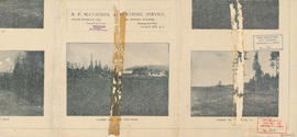
Part contains promotional images of West Vancouver and an advertisement for R.P. Matheson Advertising Service.

Indexed guide map of the city of Vancouver and suburbs
Part of City of Vancouver Archives technical and cartographic drawing collection
Part is a map showing district lots, blocks, and boundaries between the City of Vancouver, Point Grey, South Vancouver, Burnaby, New Westminster, and parts of Richmond, North Vancouver and West Vancouver. Concentric circles indicate the distance in miles from the intersection of Main Street and Hastings Street in intervals of 1/2 mile.

Map of West Vancouver and vicinity
Part of City of Vancouver Archives technical and cartographic drawing collection
Part contains a map of West Vancouver, North Vancouver, and the northern parts of Vancouver and Burnaby. Map shows district lot and block numbers, streets, and distances from City Hall.