
Burrard Inlet - triangulation control
- AM1594-MAP 1157-: LEG1153.062
- Item
- 1921
Part of City of Vancouver Archives technical and cartographic drawing collection
22 results with digital objects Show results with digital objects
Burrard Inlet - triangulation control
Part of City of Vancouver Archives technical and cartographic drawing collection
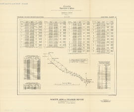
North Arm of Fraser River - triangulation control
Part of City of Vancouver Archives technical and cartographic drawing collection

Fraser River - triangulation control
Part of City of Vancouver Archives technical and cartographic drawing collection

Burrard Inlet - Port Moody sheet
Part of City of Vancouver Archives technical and cartographic drawing collection

Part of City of Vancouver Archives technical and cartographic drawing collection

Burrard Inlet - Dollarton sheet
Part of City of Vancouver Archives technical and cartographic drawing collection

Burrard Inlet - Second Narrows sheet
Part of City of Vancouver Archives technical and cartographic drawing collection

Burrard Inlet - Vancouver sheet
Part of City of Vancouver Archives technical and cartographic drawing collection

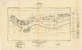
North Arm of Fraser River - Point Grey sheet
Part of City of Vancouver Archives technical and cartographic drawing collection

North Arm of Fraser River - Ione Island sheet
Part of City of Vancouver Archives technical and cartographic drawing collection
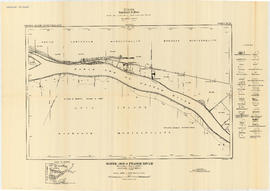
North Arm of Fraser River - Marpole sheet
Part of City of Vancouver Archives technical and cartographic drawing collection
North Arm of Fraser River - Boundary Road sheet
Part of City of Vancouver Archives technical and cartographic drawing collection

North Arm of Fraser River - Poplar Island sheet
Part of City of Vancouver Archives technical and cartographic drawing collection

Fraser River - Port Mann sheet
Part of City of Vancouver Archives technical and cartographic drawing collection

Fraser River - New Westminster sheet
Part of City of Vancouver Archives technical and cartographic drawing collection

Fraser River - Annacis Island sheet
Part of City of Vancouver Archives technical and cartographic drawing collection

Fraser River - Tilbury Island sheet
Part of City of Vancouver Archives technical and cartographic drawing collection

Fraser River - Deas Island sheet
Part of City of Vancouver Archives technical and cartographic drawing collection

Part of City of Vancouver Archives technical and cartographic drawing collection

Fraser River - Steveston sheet
Part of City of Vancouver Archives technical and cartographic drawing collection

Fraser River - Sand heads sheet
Part of City of Vancouver Archives technical and cartographic drawing collection
Part of City of Vancouver Archives technical and cartographic drawing collection
File consists of 18 maps and 3 sheets of associated triangulation and other survey control data, published by the Geological Survey of Canada. The maps depict a geological survey of the banks, islands, marshes, etc. of the Fraser River, North Arm of the Fraser River and Burrard Inlet.
Fraser River Delta, British Columbia
Part of City of Vancouver Archives technical and cartographic drawing collection
Item is a map with section showing the geology and topography of the Fraser River Delta region. The map depicts surface deposits and bedrock outcrops over different periods of time. Oil and gas well locations are also included.

Geological map of parts of Nanaimo and New Westminster mining divisions
Part of City of Vancouver Archives technical and cartographic drawing collection
Item is a map showing Tertiary, Mesozoic, and Paleozoic areas and includes descriptive notes. Map drawn "To illustrate report by O. E. Leroy, M. Sc., 1906."