- AM1519-: 2009-139.1
- Item
- 1939
Item is an advertising broadsheet for Monel brand metal products and appliances, as featured in "the new Hotel Vancouver." Includes interior views of the hotel's kitchen and utility areas, and one exterior view.
25 results with digital objects Show results with digital objects
Item is an advertising broadsheet for Monel brand metal products and appliances, as featured in "the new Hotel Vancouver." Includes interior views of the hotel's kitchen and utility areas, and one exterior view.
H.R.H. the Duke of Edinburgh's second Commonwealth study conference : Canada 1962
Limited Edition : eighty-two contemporary townhomes in the Shaughnessy estate tradition
Soho at the village : on Mainland Street between Smithe and Nelson Street
Mackenzie Green : the height of luxury : coming soon to Mackenzie Heights
Maddox Downtown : a pledge of place, form, and trust
Maddox Downtown : coming this May
Torvill and Dean : the world tour : itinerary
A Sign for the City : May 2011 - April 2012
Item is a calendar notebook for a public art project by Sabine Bitter & Helmut Weber.
Item is a booklet featuring working drawings and information about a public art work installation.
Main Street : the neighbourhood magazine of Riley Park - Little Mountain
Item is a community magazine.
Item is a community magazine.
Item is a community newspaper.
Item is a community newspaper including the 25th anniversary story of Sunset Memorial Centre.
Item is a community newspaper.
Item is a community newspaper.
du Maurier council presentation
Item is a duMaurier Pop Concerts progamme.
The CHQM great composer series : 1974
The Vancouver Symphony Orchestra presents the Sun Centennial Festival : concert 3
Item is a programme for a family concert.
Item is a brochure promoting the Playhouse Theatre Company's third season.
Dance, ballet & broadway : Anna Wyman Dance Theatre
Item is a programme for a gala performance at Queen Elizabeth Theatre, November 27, 1985.
Vancouver Symphony Orchestra gala Orpheum opening : April 2, 1977
Item is a souvenir programme including the history of the VSO and the Orpheum Theatre.
The vegetation of the floodplains of the Lower Fraser, Serpentine and Nicomekl Rivers, 1859 to 1890
Item is an academic article.
Plan of the City of Vancouver [BC] Western Terminus of the Canadian Pacific Railway
Part of City of Vancouver Archives technical and cartographic drawing collection
The map shows the city of Vancouver in 1886. The map displays the CPR Railway tracks throughout Vancouver. The bodies of water - False Creek, Burrard Inlet, and Coal Harbour - are emphasized with approximately 5cm of blue pencil outlining the bodies of water. Additionally, streets, parks, and residential lots are also depicted.
The Northernmost point on the map is the Indian Reserve and the intersection of Capilano River and the First Narrows river, and the Southernmost point is the Due West City Boundary (listed at N 89 05 W). The Easternmost is the City Boundary for the townside of Hastings (listed at 55? E) and the Westernmost road on the map is Campbell Street.
A detailed compass, in the middle of the map, shows Astronomic North.
Map of Vancouver British Columbia
Part of City of Vancouver Archives technical and cartographic drawing collection
The map of Vancouver shows streets, bus routes, railways, and postal block numbers. The map?s buildings are quite detailed, and it includes depictions of fire halls, libraries, hospitals, and schools. Red and green annotations show the divisional boundaries of wards and polling stations. One mile circles radiate from City Hall. A Street Index appears at the bottom of the map, and this gives the coordinates of different roads.
The westernmost identifiable point on the map is Marine Drive and the easternmost road is Boundary Road while the northernmost is Stanley Park, and the southernmost is Sea Island and Lulu Island.

Part of City of Vancouver Archives technical and cartographic drawing collection
Map shows the Pacific Coast from Prince William Sound in the north though the Queen Charlotte Islands, Vancouver Island, Port S. Francisco and Sn. Diego to Sn. Domingo in the south.
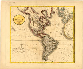
A new map of America, from the latest authorities
Part of City of Vancouver Archives technical and cartographic drawing collection
Map shows North America, South America, Greenland, islands in the Pacific and Atlantic oceans and parts of western Africa and western Europe.

Part of City of Vancouver Archives technical and cartographic drawing collection
Primary map shows towns, states and territories in North America and Central America. An ancillary map shows the "Hawaiian Group or Sandwich Islands".

Part of City of Vancouver Archives technical and cartographic drawing collection
Item is a map showing the Pacific Coast of British Columbia and Washington and Oregon states as surveyed by French explorer Jean-Francois de Galaup (Laperouse) in 1786, and the routes of his ships Astrolabe and Boussole. The map shows the Pacific coastline from Cap Rond (Tillamook Head) in Oregon at latitude 45 degrees and 40 minutes in the south to Baeie de Clonard (Beresford Bay, northwestern tip of Haida Gwaii) in British Columbia at latitude 54 degrees and 10 minutes in the north. Other major place names on the map include Nootka, Pointe Boisee, Baie St. Louis, Iles de Sartine, Mont Fleurieu, Cap Fleurieu, Cap Hector, Mont de la Touche, Baie de la Touche, and Baie de Clonard. Vancouver Island is shown as part of the mainland. Map includes latitudes and longtitudes as well as indication of elevations. Map is a plate from the "Atlas de Voyage de la Perouse".
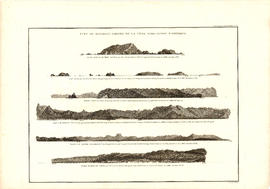
Vue de diverses parties de la côte nord-ouest d'Amérique
Part of City of Vancouver Archives technical and cartographic drawing collection
Item is a graphical plate from an atlas, showing views of Cape Scott, Scott Island, the entrance to Nootka Sound, Woody Point, the entrance to the Columbia River, and Point Barro de Arena. The item is a plate from a French reprinting of "A Voyage of Discovery to the North Pacific Ocean and round the world..." by George Vancouver.
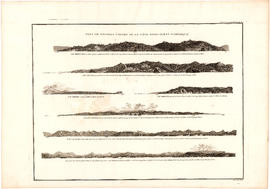
Vue de diverses parties de la côte nord-ouest d'Amérique
Part of City of Vancouver Archives technical and cartographic drawing collection
Item is a graphical plate from an atlas, showing views of Cape Mendocino, Cape Orford, Grenville Point, the entrance to the Straits of Juan de Fuca and the coastline south of Cape Flattery. The item is a plate from a French reprinting of "A Voyage of Discovery to the North Pacific Ocean and round the world..." by George Vancouver.
Part of City of Vancouver Archives technical and cartographic drawing collection
Map shows major roads, parks, landmarks and tourist attractions in Vancouver and parts of West Vancouver, North Vancouver and Burnaby. The map shows the area from Grouse Mountain in the north to Vancouver International Airport in the south and from Burnaby Lake in the east to Lighthouse Park and the University Endowment Lands in the west
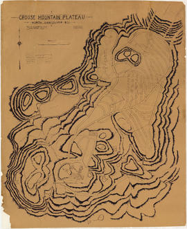
Grouse Mountain Plateau, North Vancouver, B.C.
Part of City of Vancouver Archives technical and cartographic drawing collection
Item is a topographic map showing the contours of Grouse Mountain Plateau, and various lakes, ponds, and creeks, and industrial developments including parking roads, parking areas, bridges, and scenic trails.
Let's go see! Inside Vancouver
Part of City of Vancouver Archives technical and cartographic drawing collection
Item is a tourist brochure featuring information on attractions on the North Shore (North Vancouver and West Vancouver) and maps showing routes to the area.
Part of City of Vancouver Archives technical and cartographic drawing collection
Item is a pamphlet with a map of the Lower Mainland on one side and information about Delta, Chilliwhack [sic], Surrey, New Westminster, Maple Ridge, Langley, and British Columbia on the other.

Map of the United States and territories together with Canada etc.
Part of City of Vancouver Archives technical and cartographic drawing collection
Item is a map showing the boundaries of U.S. territories and states and the southern portion of Canadian colonies of Vancouver Island, British Columbia, Canada East, Canada West, as well as New Brunswick, Prince Edward Island and Nova Scotia. The map also shows cities and principal geographical features. Two inset maps show "Hampton Roads and Norfolk Harbour" and "Pensacola Bay" in greater detail.
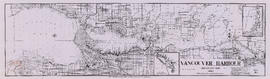
Vancouver Harbour, British Columbia, 1964
Part of City of Vancouver Archives technical and cartographic drawing collection
Item is a nautical chart showing English Bay and Burrard Inlet with soundings in feet, anchorages, locations of submarine cables, and ferry lines. Land features include city blocks and district lot numbers. Includes inset maps of the North Arm of Burrard Inlet and Vancouver Island.

Stuart's pocket map of Vancouver, B.C.
Part of City of Vancouver Archives technical and cartographic drawing collection
Item is an illustrated map of the "old" City of Vancouver. The map shows streets, transportation, and significant businesses (such as C.P.R. wharves, smelter, Hastings Mill, Morse's Mill, C.P.R. Shops, City Hospital, sawmill, slaughter houses, and smallpox hospital). The map includes "Index of Streets, Government Offices, Churches, [etc.], including "Civic and other Principal Buildings", "Places of Amusement or Recreation", "Public Schools", "Principal Mills, Foundries and Manufactories", "Principle Bankers", Principal Hotels", and "Miscellaneous".
The map was designed to be folded into a cover, which is included.

Port Moody, the western terminus of the Canadian Pacific Railway
Part of City of Vancouver Archives technical and cartographic drawing collection
Item is a map showing lots surveys and made available for purchase in Port Moody.

"Know your city" : Buckley's map of Vancouver (un-abridged)
Part of City of Vancouver Archives technical and cartographic drawing collection
Item is an illustrated map with a farcical, cartoon-like, illustration of Vancouver. The map contains cartoonish depictions of various Vancouver "types" and neighbourhoods, including racist caricatures, as well as a key to sewerage systems, government liquor stores, and other oddities.
Map of Vancouver Unemployment and Relief [BC]
Part of City of Vancouver Archives technical and cartographic drawing collection
The map shows relief and elevations of Vancouver. It depicts streets, parks, and railways, and residential and industrial areas.
The annotations in black ink trace parts of the map: names, railways, and the coast line. The amendments also show Cases and Persons of Domiciled Residents in the Vancouver Area, in May 1934. The map also lists statistics of approximate Cases and Persons of Transient Families and Single Women, and Single Homeless Men.
Pensions and Compensation statistics are also compiled for: Mothers Pensions, Old Age Pensions, War Pensions, amd Workmen's Compensation as of the population of Vancouver in 1931.
The westernmost boundary of the map is Boundary Road and the easternmost boundary is the University of British Columbia while the northernmost is the Burrard Inlet and the southernmost is Sea Island and Lulu Island.
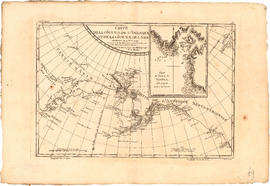
Carte de la cote N.O. de l' Amerique et de la cote N.E. de l'Asie
Part of City of Vancouver Archives technical and cartographic drawing collection
Item is a map showing the north west coast of America and the north east coast of Asia. Inset maps shows the entrance to Nootka Sound.

Carte de la riviere de Cook dans la partie N.O. de l'Amerique
Part of City of Vancouver Archives technical and cartographic drawing collection
Item is a nautical chart showing "Cook's River" [Cook Inlet, Alaska]; the inset chart shows Oonalaska Island and gives soundings for "Samganoodha harbour" and the waters around the island.

Plan of the townsite of North Vancouver
Part of City of Vancouver Archives technical and cartographic drawing collection
item is a map showing lots and land subdivision in North Vancouver, most likely related to real estate sales. Index map shows the location of North Vancouver relative to Greater Vancouver.
New Westminster, British Columbia
Part of City of Vancouver Archives technical and cartographic drawing collection
Map shows the portion of New Westminster south of Columbia Street to the Fraser River. Land subdivision for the area is shown and streets are identified. Inset shows the location of New Westminster in relation to the rest of the Lower Mainland, B.C.
Commercial Map of Greater Vancouver and District [BC]
Part of City of Vancouver Archives technical and cartographic drawing collection
The map shows the Greater Vancouver Area and its roads, streets, and residential, commercial, and industrial districts in July 1924. In accordance with the legend, the map shows railroads, electric railways, parks, and buildings. The map uniquely depicts the center of Vancouver which is approximately 5400 feet and spans from Water and Railway Street to Prior Street and Abbott Street to Princess Street. The center circle then concentrically expands outwards with other circles marking every mile outward.
Additionally, there are annotations in black, red, yellow, and green. The black annotations mark topography and contour lines with listed elevations. The red annotations mark water gauges. The yellow annotations indicate the best routes through the City and District as suggested by the Automobile Club of BC. The green annotations appear for an unknown reason.
The Westernmost road on the map is Marine Drive and the Easternmost is Columbia Street and North Road while the Northernmost road on the map is Dempsey St. in North Vancouver and the Southernmost point is No. 20 Road.
City of Vancouver British Columbia
Part of City of Vancouver Archives technical and cartographic drawing collection
The map is a positive blueprint of the City of Vancouver with boundaries, streets block numbers & the harbour headline. A detailed compass appears in the top left corner of the map. The legend is also in the top left hand corner depicting City boundaries, Harbour headlines, Postal Blocks, and street numbers. There is a copy of the Map included, Map 71B, and it includes the Geographic Census Tracts.
The westernmost identifiable point on the map is the Straight of Georgia, and the easternmost is Boundary Road. The northernmost point on the map is the Stanley Park, the southernmost is Sea Island and Twiggs Island.
Plan of Sewerage System Point Grey Municipality
Part of City of Vancouver fonds
The map shows the Point Grey Area and its district lot boundaries, street car lines, and postal block numbers. The map displays streets, parks, railways, and schools. Additionally, there are annotations red which mark the sewerage and drainage for the area. The size of the pipes is also incrementally listed.
The Northernmost point on the map is the English Bay and the Southernmost point is the North Arm of the Fraser River. The Easternmost is Ontario St. and Westernmost road on the map is Marine Drive beside UBC.
W.C. Grey was the engineer that produced the map.