National Harbours Board Annual report 1975
- AM1519-: PAM 1975-58
- Item
- 1975
2 results with digital objects Show results with digital objects
National Harbours Board Annual report 1975

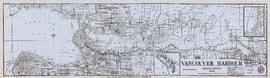
Vancouver Harbour. British Columbia
Part of City of Vancouver Archives technical and cartographic drawing collection
Item is a map sheet containing three nautical charts. The main map shows English Bay and Burrard Inlet and the land bordering these bodies of water, including North and West Vancouver, Downtown Vancouver, the University Endowment Lands and Port Moody. Inset maps depict the north arm of Burrard Inlet and a chart showing Vancouver Island in relation to the B.C. coast and the state of Washington, U.S.A.
Vancouver Harbour [sectional map]
Part of City of Vancouver Archives technical and cartographic drawing collection
File contains 42 maps showing soundings, harbour headlines, high water marks, shore lines, shoals, submarine cable, rail lines and trails in the Vancouver area. Maps also show names of businesses and other structures.
The Port of Vancouver : Canada's key city of the West
Part of City of Vancouver Archives technical and cartographic drawing collection
Item is a brochure promoting Vancouver harbour as a hub of economic activity in the city. The brochure includes illustrations of harbour activity, facts about various aspects of the operations to show the harbour's capacity and facilities.
Vancouver Harbour : plan of south shore, Burrard Inlet between Heatley Ave. and Victoria Dr.
Part of City of Vancouver Archives technical and cartographic drawing collection
Item is a map which shows parcels of land along Burrard Inlet and district lots in downtown Vancouver. Piers, factories and mills along the waterfront are identified. Soundings are shown in feet.
Vancouver Harbour, British Columbia, 1945
Part of City of Vancouver Archives technical and cartographic drawing collection
Item is a nautical chart showing English Bay and Burrard Inlet with soundings in feet, anchorages, locations of submarine cables, and ferry lines. Land features include city blocks and district lot numbers. Includes inset maps of the North Arm of Burrard Inlet and Vancouver Island. Note at the bottom of map states, "Not to be used for navigational purposes."