- AM1594-: MAP 803-: LEG1315.5
- Part
- 1948
Part of City of Vancouver Archives technical and cartographic drawing collection
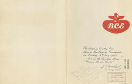
Part contains B.C. Electric logo and J.S. Matthews's annotations regarding the plan.
Part of City of Vancouver Archives technical and cartographic drawing collection
Part contains B.C. Electric logo and J.S. Matthews's annotations regarding the plan.

B.C. Electric Rly. Co. Ltd. plan showing transit services in Vancouver city as at end of 1951
Part of City of Vancouver Archives technical and cartographic drawing collection
Part is a map showing existing and proposed transit lines in Vancouver.

Part of City of Vancouver Archives technical and cartographic drawing collection
Part contains maps of the Richmond and downtown Vancouver transit systems, a street index to the Greater Vancouver map on the other side of the sheet, information on B.C. Electric transit routes, and general tourist information.

Transit system map of Greater Vancouver, B.C.
Part of City of Vancouver Archives technical and cartographic drawing collection
Part contains a map of Greater Vancouver showing bus lines, route numbers, B.C. Electric installations, block numbers, points of interest and amenities; an inset map showing streets in Gleneagles, Whytecliff, and Horseshoe Bay; and an inset map showing streets in Port Moody, Coquitlam, and Maillardville.

Part of City of Vancouver Archives technical and cartographic drawing collection
Part contains maps of the Richmond and downtown Vancouver transit systems, a street index to the Greater Vancouver map on the other side of the sheet, information on B.C. Electric transit routes, and general tourist information.

Transit system map of Greater Vancouver, B.C.
Part of City of Vancouver Archives technical and cartographic drawing collection
Part contains a map of Greater Vancouver showing bus lines, route numbers, B.C. Electric installations, block numbers, points of interest and amenities; an inset map showing streets in Gleneagles, Whytecliff, and Horseshoe Bay; and an inset map showing streets in Port Moody, Coquitlam, and Maillardville.

Transit detail inset maps ; Street index ; Transit and tourist information
Part consists of three maps showing transit details in Richmond, New Westminster and downtown Vancouver, and descriptive information about B.C. Electric routes and services and Greater Vancouver attractions.

Transit system map of Greater Vancouver, B.C.
Part consists of a map showing trolley coach lines, bus lines, street car lines, interurban lines, interurban stops, route numbers, B.C. Electric installations and block numbers in West Vancouver, North Vancouver, Vancouver, Burnaby and the University Endowment Lands.

Composite map of B.C. Electric downtown bus routes
Part shows bus routes from Burrard Inlet in the north to False Creek in the south and from Main Street in the east to Thurlow in the west.

Bus routings in the downtown area
Part contains textual information about bus routes and services.